
Rotwand (Bavaria)
| Rotwand | ||
|---|---|---|
 The eponymous rocks in the summit area of the Rotwand |
||
| height | 1884 m above sea level NHN | |
| location | Bavaria , Germany | |
| Mountain range | Mangfall Mountains ( Schlierseer Mountains ) | |
| Dominance | 5.7 km → Hinteres Sonnwendjoch | |
| Notch height | 741 m ↓ misery saddle | |
| Coordinates | 47 ° 39 '1 " N , 11 ° 56' 4" E | |
|
||
| rock | Plattenkalk , Liasbasiskalk and Oberratskalk | |
| Age of the rock | Triad | |
| Normal way | Spitzingsee - Taubenstein - Rotwandhaus - Rotwand | |

The Rotwand is 1884 m above sea level. NHN the highest point in the district of Miesbach and the highest mountain in the Bavarian part of the Mangfall Mountains and thus also the highest peak in the Spitzingsee area. It belongs to the municipality of Bayrischzell , although the mountain is one of the Schlierseer Mountains .
Munich's popular local mountain can be reached in a simple hike from Spitzingsee on various paths (e.g. through the Pfanngraben with Gumpen ). From the mountain station of the Taubensteinbahn it can be climbed even faster via the path west below the Lempersberg and is therefore often overcrowded on summer days. An alternative route leads from Geitau over the Soinsee to the summit. South of the summit is the Rotwandhaus of the German Alpine Club at 1737 m above sea level. NN.
In winter, the Rotwand is often used as a ski tour. The classic Rotwand-Reib'n leads from Spitzingsee to the Rotwand, then over the Kümpflscharte (1695 m) to the Auerspitz (1811 m), further over the Großtiefentalalm (1500 m), over the Miesingsattel (1704 m; with a detour if necessary to Hochmiesing [1883 m]) to the Kleintiefentalalm and via the Taubensteinhaus and the mountain station of the Taubensteinbahn back to the Spitzingsee. The tour is also possible with snowshoes.
The oldest human artifacts in the German Alpine region were found in the area around the Rotwand . On the saddle between Tanzeck and Rauhkopf north of Rotwandhaus were two, just east of Soinsees a stone device as reading Fund discovered. Two of the cuts are made of radiolarite , one of flint , all of which are dated to Beuronia , the oldest phase of the Mesolithic . Further finds from the same period are known on the Austrian side near the Hinterer Sonnwendjoch and on both banks of the Achensee .
The brown bear JJ1 (also called "Bruno") was shot on June 26th, 2006 at around 4.50 am in the Rotwand area after he was seen at the Rotwandhaus.
Web links
Individual evidence
- ↑ Geological map of Bavaria with explanations (1: 500,000). Bavarian State Geological Office, 1998.
- ^ Walter and Michael Pause, Munich's local mountains: the classic goals , ISBN 978-3-8354-0334-5 .
- ↑ Peter Wischenbarth: First Mesolithic finds in the Mangfall Mountains (Upper Bavaria) . In: Bavarian history sheets, year 66, 2001, pages 157–159.
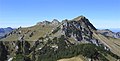
Rotwand seen from the Auerspitz
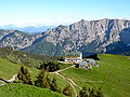
Rotwandhaus - view back from the ascent to the Rotwand

Rotwand seen from the Auerspitz


