
Taubenstein
| Taubenstein | ||
|---|---|---|
 Pigeon stone summit |
||
| height | 1692 m above sea level NN | |
| location | Bavaria , Germany | |
| Mountains | Bavarian Prealps | |
| Coordinates | 47 ° 39 '31 " N , 11 ° 55' 16" E | |
|
||
| Normal way | from Spitzingsattel | |

The Taubenstein is a 1692 m high mountain in the Schlierseer Mountains in the Mangfall Mountains ( Bavarian Prealps ). The mountain can be reached as a mountain hike, which requires surefootedness in the summit area, the quickest way to walk from the Spitzingsattel (ascent: 1:45 hours, descent 1:30 hours, 566 meters in altitude). The Taubensteinbahn cable car leads to just below the rocky summit , from whose valley station you can climb to the summit in a similar time. The Taubensteinhaus is located a bit northeast of the summit .
- View from the top
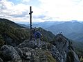
Summit cross

North with Jägerkamp and Benzingspitz

Northeast with Wendelstein

South, Rotwand on the left , Lempersberg on the right

Southwest, in the middle of the picture Austrian Schinder (left) and Bavarian Schinder (right), in between the Guffert

West with Risserkogel


