Auerspitz
| Auerspitz | ||
|---|---|---|
| height | 1811 m above sea level NHN | |
| location | Bavaria , Germany | |
| Mountains | Mangfall Mountains , Bavarian Prealps | |
| Dominance | 0.8 km → Rotwand | |
| Notch height | 116 m ↓ Kümpflscharte | |
| Coordinates | 47 ° 38 '38 " N , 11 ° 56' 44" E | |
|
|
||
|
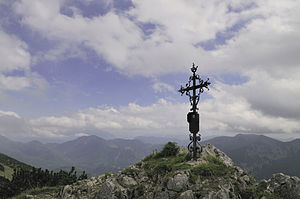
Summit cross |
||
The Auerspitz is a 1810.5 m above sea level. NHN high mountain in the Mangfall Mountains , part of the Bavarian Prealps .
Location and summit panorama
The Auerspitz is located in the municipality of Bayrischzell in Bavaria not far from the Kufstein district in the state of Tyrol in Austria . The view from the summit in the south is dominated by the rugged north face of the Hinterer Sonnwendjoch . In the distance, the Wilder Kaiser and Großvenediger can also be seen . To the north are the peaks of Rotwand , Hochmiesing and those of the Ruchenköpf and the Soinsee in the immediate vicinity . The Wendelstein can also be seen to the east .
Climbing opportunities
The Auerspitz can be climbed on various routes as an easy to moderately difficult hike:
- The starting point for two types of ascent is a hiking car park at an altitude of 820 m, three kilometers south of Bayrischzell on the connecting road to the Austrian municipality of Thiersee . A first route leads past the Sillberghaus located at an altitude of 1040 m , which can be reached in just half an hour. This section of the route is also the steepest part of the route. The Sillberghaus is a privately run refreshment stop that is only open on weekends and public holidays, and has 30 places to stay. Behind the Sillberghaus, follow the wide road in the direction of the Rotwandhaus , whereby the path mostly leads over open terrain and passes the Wirthsalm and later the Sandbichleralm . North of the path rises the 1688 m high and mostly wooded Maroldschneid . The road ends behind the Sandbichleralm and the path leads over narrow mountain paths, first through a basin, then over a ridge to the summit of the Auerspitz. The total walking time is approx. 2¾ hours for the ascent and 2¼ hours for the descent.
- Another path leads from the hiking car park past the Sillberghaus over the so-called Bayrischzeller Höhenweg to the Soinalmen at an altitude of 1400 m . Behind it you pass the Soinsee and the rugged south walls of the Ruchenköpfe. After a total of 2¾ hours you reach the summit of the Auerspitz. The first two routes are often combined to form a circular hike, with the Maroldschneid being completely circled.
- In addition, the summit of the Auerspitz can be reached in 30 minutes from the Rotwandhaus , whereby the approach to the Rotwandhaus from the Spitzingsee takes around 2½ hours.
Web links
Commons : Auerspitz - collection of images, videos and audio files
Individual evidence
- ↑ Map service of the Federal Agency for Nature Conservation
- ↑ Tour description on the Auerspitz, information from the hiking portal hoehenrausch.de, accessed on September 3, 2010
- ↑ Information from the hiking portal Steinmandl.de, accessed on April 7, 2011
- ↑ Information from the hiking portal Tourentipp, accessed on September 3, 2010
View of Rotwand, Hochmiesing, Ruchenköpf, Wendelstein, Soinsee


