
Ruchenköpf
| Ruchenköpf | ||
|---|---|---|
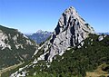
 Ruchenköpfe from the southwest |
||
| height | 1805 m | |
| location | Germany ( Bavaria ) | |
| Mountains | Bavarian Prealps ( Mangfall Mountains ) | |
| Dominance | 0.49 km → Auerspitz | |
| Notch height | 86 m | |
| Coordinates | 47 ° 38 '59 " N , 11 ° 57' 0" E | |
|
||
| Normal way | Soinsee - Bergwachthütte - Chives Channel - Summit | |

Ruchenköpfe is the name of a 1805 meter high mountain with a long, striking ridge that has several ridges and is located in the Schlierseer Mountains , part of the Mangfall Mountains , in Bavaria .
location
The Ruchenköpf are located between the Hochmiesing / Dürrmiesing in the north, the Rotwand in the west, the Auerspitz in the south and the Soinsee in the east. The Ruchenköpf can be reached from the Rotwandhaus of the German Alpine Club (DAV) or via the Soinsee from Geitau or Osterhofen or from the Ursprung valley via the Sillberghaus and Ruchenkopfhütte.
Routes
The simplest ascent, often used as a descent, leads past the Bergwacht hut (Bergwacht München), first through a pine belt and then steep and unmarked, partly on a trail with climbing points of difficulty I through the chive and partly exposed over the eastern summit ridge to the summit cross Book (surefootedness, a head for heights and climbing skills required); The west ridge is considered more attractive (level of difficulty III (more difficult places with bolted hooks), also not marked, very exposed to " women fright "). Danger from orientation problems.
The Ruchenköpfe are a preferred destination for sport climbers, especially from the Munich area. The Munich Riss and the Dülfer Riss , both on the southwest face of the Ruchenköpfe , are among the most famous climbing tours in the Bavarian Prealps in the medium difficulty range .
photos

Summit cross

Normal route via the chive channel

Ruchenköpf, in the background the Wendelstein
Ruchenköpf, in the background the Wendelstein
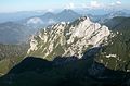
View of the Ruchenköpf from the west
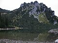
Soinsee with Ruchenköpf from the east


