Hinteres Sonnwendjoch
| Hinteres Sonnwendjoch | ||
|---|---|---|
|
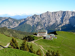
North side of the Hinterer Sonnwendjoch with the Rotwandhaus |
||
| height | 1986 m above sea level A. | |
| location | Tyrol , Austria | |
| Mountains | Mangfall Mountains , Bavarian Prealps | |
| Dominance | 13 km → Guffert | |
| Notch height | 955 m ↓ change | |
| Coordinates | 47 ° 35 '54 " N , 11 ° 56' 58" E | |
|
|
||
| rock | Main dolomite , plate limestone | |
| Age of the rock | Upper Carnium - Norium | |
|
The summit of the Hinteren Sonnwendjoch from the southwest |
||
The Hintere Sonnwendjoch in Tyrol is at 1986 m above sea level. A. the highest mountain of the Mangfall Mountains , a part of the Bavarian Prealps . Since the southern part of the Brandenberg Alps is lower, the summit offers excellent views of the Central Alps despite its relatively low height . The rear Sonnwendjoch falls steeply to the north in the ground at his peak is from Hauptdolomit and on the south side of Plattenkalk established.
A long but easy mountain hike from Valepp (890 m) in Bavaria leads over the Bärenbadalm (1590 m) to the summit. The ascent from the Ackernalm ( 1383 m ) in the south of the massif, which can be easily reached via a toll road from Bayrischzell or Kufstein, is much shorter and also easy .
Web links
Individual evidence
- ↑ Provisional Geological Map of the Republic of Austria 1: 50,000, published by the Federal Geological Institute , Vienna 2007/09, sheet 89 Angath


