Stolzenberg (Mangfall Mountains)
| Stolzenberg | ||
|---|---|---|
|
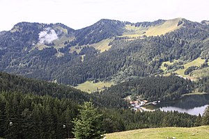
Stolzenberg (left), Rotkopf (center) and Roßkopf (right) in the Bavarian Mangfall Mountains southeast of the Spitzingsee (bottom right) |
||
| height | 1609 m above sea level NN | |
| location | Bavaria , Germany | |
| Mountains | Mangfall Mountains | |
| Coordinates | 47 ° 38 '33 " N , 11 ° 52' 21" E | |
|
|
||
| Normal way | from the Valeppalm near Spitzingsee or from the service hut Ankerstube | |
The Stolzenberg is a 1609 m high mountain in the Mangfall Mountains in the Bavarian Prealps . The mountain can be reached as a simple hike from the Valeppalm near Spitzingsee or from the service hut Ankerstube via the Stolzenalm. Transition to the red head .
In contrast to the soft, wooded ( Rotkopf ) or grassy ( Roßkopf ) peaks made of Jura marl to the northwest , the jagged summit ridge of the Stolzenberg, which runs in an east-west direction, juts out from Kössen layers in the north in a thin, almost vertically folded, rocky layer from Oberrats -Reef limestone steep up.
Web links
Individual evidence
- ↑ Bavarian Geological State Office: Geological Map of Bavaria, sheet 665 Schliersee (status 1982)

