
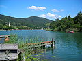
Schliersee
| Schliersee | ||
|---|---|---|

|
||
| Schliersee around 1900 | ||
| Geographical location | 51 km southeast of Munich | |
| Tributaries | Breitenbach , Trattengraben, Schindelgraben, Mühlgraben, Leitner Graben, Ostergraben | |
| Drain | Schlierach , after 13 km Münd. in the Mangfall | |
| Islands | Wörth | |
| Places on the shore | Schliersee , Fischhausen | |
| Data | ||
| Coordinates | 47 ° 43 '29 " N , 11 ° 51' 44" E | |
|
||
| Altitude above sea level | 777 m above sea level NHN | |
| surface | 2.22 km² | |
| length | 2.515 km | |
| width | 1.253 km | |
| volume | 53,130,000 m³ | |
| scope | 7.4 km | |
| Maximum depth | 40.5 m | |
| Middle deep | 23.9 m | |
| Catchment area | 27.15 km² | |

The Schliersee is a lake in the Bavarian Alps in the Miesbach district .
geography
The Schliersee is located about 50 kilometers southeast of Munich , between the Tegernseer Tal and Inntal , near the Austrian border in the Bavarian Prealps . It lies at a height of 777 m above sea level. NHN and has an area of 2.22 km². The lake has an average depth of 23.9 meters and a maximum of 40.5 meters. Its catchment area measures 27.1 km². In the lake is the 2.4 hectare island of Wörth , which is built on with an inn . This island is the part of a massive transverse dam that protrudes above the water level and divides the lake into two basins.
The Freudenberg peninsula juts out into the lake from the north-west and is part of another, only partially existing transverse bar that used to connect to the vineyard (hill) with the St. Georg chapel on the north-eastern shore of the lake.
The lake is owned by the Free State of Bavaria; the Bavarian Administration of State Palaces, Gardens and Lakes is responsible for its administration .
From a geological point of view, the northern part of the lake lies in the flysch zone , the southern part in the northern limestone range .
The inflow consists mainly of smaller springs. The notable exception is the Breitenbach , which flows into the lake in the northwest in the district of Schliersee at the campsite. The only route is the Schlierach immediately north of the Freudenberg peninsula.
The Schliersee belongs entirely to the Schliersee market ; the districts of Neuhaus and Fischhausen are among the most popular holiday and excursion regions in Bavaria .
ecology
The Schliersee was in an ecologically questionable condition for a long time , as it was still eutrophic despite a circular sewer system that was completed in the mid-1970s . The strong growth of the burgundy blood algae , a type of blue-green algae , made the water look blood red. It was soon discovered that the sheltered location and the long ice cover in spring inhibited the natural circulation of the water.
To change this situation, a linear compressed air line was installed in both basins of the lake in 1982, which can largely circulate the lake in three to four days. This measure is evidently successful, since since then neither algal blooms nor fish deaths have occurred to any significant extent.
sport and freetime
In the summer months from May to September, a liner operates daily on the lake. In contrast to the other lakes in Upper Bavaria, the ship is not operated by Bayerische Seenschifffahrt , but by private Schlierseeschifffahrt . 45-minute tours take place daily from 11:00 a.m. to 5:00 p.m.
The Alpine Triathlon takes place annually in June at Schliersee . In this triathlon over the Olympic distance (1.5 km swimming, 40 km cycling, 10 km running), the German championships have been held several times since 2006.
photos

View from the Jägerkamp

Schliersee seen from the Brecherspitz
Across the lake to the southeast
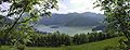
View from the Schliersbergalm


See also
literature
- Ignaz Joseph von Obernberg : On the history of the churches and localities Westenhofen and Schliersee . In: Upper Bavarian Archive for Fatherland History , Volume 2, Munich 1840, pp. 281–294 ( online ).
- S. v. M .: The Fischer-Lisel . In: The Gazebo . Issue 38, 1867, pp. 601-603 ( full text [ Wikisource ]).
- Reinhold Friedrich: Traces of National Socialism in the Bavarian Oberland: Schliersee and Hausham between 1933 and 1945 . Hausham 2011.
Web links
- Level in the Danube area: Schliersee / Schliersee. Bavarian State Office for the Environment : Flood news service
References and comments
- ↑ a b c d e f g h Part 11: Bavaria . (PDF; 1.7 MB) Documentation of the condition and development of the most important lakes in Germany
- ↑ calculated from the bank development
- ↑ landkreis-miesbach.de
- ↑ Low water information service
- ↑ Alois Geistbeck: The South Bavarian and North Tyrolean lakes . In: Journal of the German and Austrian Alpine Association , year 1885, Volume XVI, pp. 334–354, here pp. 345–346, Textarchiv - Internet Archive
- ↑ Schliersee . Bavarian Administration of State Palaces, Gardens and Lakes
- ↑ Lake Therapy Schliersee. Rosenheim Water Management Office
- ↑ Timetable Schliersee shipping
- ↑ Motorschiff Schliersee III ( Memento from September 24, 2015 in the Internet Archive ; PDF; 56 kB)
- ↑ Schlierseer Schifffahrt ( Memento from September 24, 2015 in the Internet Archive )