Crusher tip
| Crusher tip | ||
|---|---|---|
|
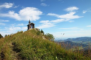
The summit of the Brecherspitz from the west |
||
| height | 1683 m above sea level NHN | |
| location | Bavaria , Germany | |
| Mountains | Mangfall Mountains ( Schlierseer Mountains ) | |
| Dominance | 2.2 km → Jägerkamp | |
| Notch height | 554 m ↓ Spitzingsattel | |
| Coordinates | 47 ° 40 '35 " N , 11 ° 52' 16" E | |
|
|
||
| Normal way | Spitzingsattel - Obere Firstalm - Freudenreichsattel - Brecherspitz | |
The Brecherspitz is a 1683 meter high mountain in the Mangfall Mountains in the Bavarian Prealps .
location
The Brecherspitz is about three kilometers as the crow flies south-southwest of Neuhaus am Schliersee ; its east ridge extends to the Spitzingsattel . It belongs to the middle mountain group of the Mangfall Mountains, the Schlierseer Mountains . With its distinctive pyramid shape, it is considered the Schliersee's local mountain. The mountain is mentioned for the first time in the years 1078-1080 in a border description of the Hochstift Freising as "mons Spizzinch" (the mountain Spitzing).
The entire Mangfall Mountains are one of Munich's local mountains and the Brecherspitz is one of the quickest rocky peaks to be reached from Munich. The mountain is easily accessible by public transport ( Bayerische Oberlandbahn to Fischhausen-Neuhaus; bus to Spitzingsee or to the Enterrottach toll station in Rottach-Egern -Kalkofen).
Routes
- The Brecherspitz is usually approached from Neuhaus. The route initially runs south on the path through the Dürnbachwald past the Anklalm and over the north ridge in 2½ hours to the summit (difference in altitude 880 m).
- From the Spitzingsattel a path leads in a westerly direction through the Blaik to the Oberen Firstalm , then right over the pre-summit and from there over the west ridge over a partly exposed path with some safety ropes (surefootedness and a head for heights required at the ridge crossing; there have already been several fatal falls there ), Duration approx. Two hours, height difference 560 meters (more difficult than the tour from Neuhaus).
- Directly from the Spitzingsattel you go over the east ridge on an unmarked, partly very steep and exposed path track with several short climbing points (I), key point very exposed; Dangerous in wet and / or snowy conditions - not recommended for the descent (sign “No descent - danger to life”). This route is only suitable for experienced mountaineers, as it requires alpine experience, surefootedness, a head for heights and some climbing skills.
- The Brecherspitz is also popular with ski tourers, because the southwest slope above the Firstalm, which was previously used as a slope, is ideal for skiing. The former surface lift was dismantled except for a few foundations. However, only the pre-summit (west shoulder) is usually climbed in winter. There is also a wind measuring station from the Avalanche Warning Service in Bavaria.
Winter sports
A ski lift led to the pre-summit of the Brecherspitz until about 1997, which was finally dismantled in 2010. This area with the Freudenreich lift and the Lower and Upper Firstalm lifts was connected to the Spitzingsee ski area. Today the Brecherspitz is a popular ski touring destination.
Literature and map
- Marianne and Emmeram Zebhauser: Alpine Club Guide Bavarian Prealps East. Bergverlag Rother , Munich 1992, ISBN 3-7633-1120-3 .
- Alpine Club Map 1: 25,000, sheet 7/1, Tegernsee, Schliersee.
Individual evidence
- ↑ Martin Bitschnau , Hannes Obermair : Tiroler Urkundenbuch, II. Department: The documents on the history of the Inn, Eisack and Pustertal valleys . tape 1 : By 1140 . Universitätsverlag Wagner, Innsbruck 2009, ISBN 978-3-7030-0469-8 , p. 227, No. 257 .
- ↑ report in the Alpine Forum


