
Kreuth
| coat of arms | Germany map | |
|---|---|---|

|
Coordinates: 47 ° 39 ' N , 11 ° 45' E |
|
| Basic data | ||
| State : | Bavaria | |
| Administrative region : | Upper Bavaria | |
| County : | Miesbach | |
| Height : | 787 m above sea level NHN | |
| Area : | 122.24 km 2 | |
| Residents: | 3608 (Dec. 31, 2019) | |
| Population density : | 30 inhabitants per km 2 | |
| Postcodes : | 83708, 83700, 83707 | |
| Primaries : | 08029, 08022 | |
| License plate : | MB | |
| Community key : | 09 1 82 124 | |
| LOCODE : | DE KYN | |
| Community structure: | 17 parts of the community | |
| Address of the municipal administration: |
Northern main street 14 83708 Kreuth |
|
| Website : | ||
| Mayor : | Josef Bierschneider ( CSU ) | |
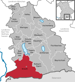
| Location of the community of Kreuth in the Miesbach district | ||
  |
||

Kreuth is a municipality in the Upper Bavarian district of Miesbach . The climatic health resort is located on the southern bank of the Tegernsee . Kreuth stretches with 17 parts of the municipality from the Tegernsee through the wide river valley of the Weißach to the state border to Tyrol at an altitude between 725 m at the Tegernsee to the summit of the Halserspitz 1862 m above sea level. NHN .
geography
location
Kreuth is the largest and most southern municipality in the Miesbach district in terms of area. In addition to Tegernsee , Rottach-Egern , Bad Wiessee and Gmund , Kreuth is one of five villages in the Tegernsee valley. The village is located around 25 km from Miesbach , 28 km from Bad Tölz , 30 km from Holzkirchen , 60 km from the state capital Munich and 40 km from Jenbach in Tyrol . Neighboring communities on the German side are Bad Wiessee in the north, Rottach-Egern in the east and Lenggries in the west. In the south, the Mangfall Mountains form the municipality and state border with Achenkirch in the Schwaz district in Austria .
Parts of the municipality and settlements
The municipality has 17 officially named municipal parts (the type of settlement is given in brackets ):
|
|
Waters

At the Ringsee, the municipality of Kreuth borders directly on the Tegernsee . Among the major rivers and streams in the municipality include the Weißach which Sagenbach , the Schwarzbach , the Albert Bach , the Klammbach the Hofbauernweißach well as a number of smaller streams like the Wisengraben . The Mühlbach Canal runs in the north of the municipality .
history

The history of the place goes back to the time of the Tegernsee monastery , from which the "Kreuther Winkel" was reclaimed and settled. This is where the name "Kreuth" comes from, which means something like "the cleared / reused".

The abbot Rupert I. von Neuburg-Falkenstein of the Tegernsee monastery had a stone chapel built in Kreuth in 1184. Because of the dilapidation this chapel was demolished in 1490. The Tegernsee abbot Ayrinschmalz had a new church built in the Gothic style by 1491. The Kreuther Leonhardifahrt was first mentioned in a document in 1442. Other churches in the municipality are the Church of the Visitation of Mary in Glashütte, consecrated in 1700, and the Chapel of the Holy Cross in Wildbad Kreuth, built in 1706.
Kreuth was part of the Tegernsee monastery district until 1803. Kreuth became an independent political community in the course of the administrative reforms in Bavaria in 1818.
Nationwide caused a stir in 1976 in Wildbad Kreuth combined Kreuther separation decision . Every year in January, the CSU regional group's retreats took place there in the educational center operated by the Hanns Seidel Foundation from 1975 to 2016.
Kreuth has been part of the international alpine club initiative Bergsteigerdörfer since 2018 .
Population development
Between 1988 and 2018 the municipality grew from 3,403 to 3,570 by 167 inhabitants or 4.9%.
politics
Established by the Bavarian State Development Program (LEP), Kreuth has been assigned to the Mittelzentrum Tegernseer Tal since May 2016 . This gives Kreuth, as a rural and structurally weak area, more scope for further development in the future.
Municipal council
The past local elections led to the following allocation of seats in the local council :
| Party / list | 2014 | 2020 |
|---|---|---|
| CSU | 8th | 7th |
| FWG | 5 | 4th |
| SPD | 3 | 3 |
| Green List Kreuth | - | 2 |
| total | 16 | 16 |
mayor
Mayor Josef Bierschneider, elected for the first time in 1998 at the age of 26, was - as in 2004 and 2010 - confirmed in office for another six years on September 25, 2016 without a competitor.
coat of arms
In the award of the coat of arms by the State Ministry of the Interior in 1965, the blazon reads: “Divided by green and silver; above a chamois head, below two lake leaves with intertwined stems in mixed up colors. ”The Gamskopf symbolizes the alpine location of the community, which extends from the rear Tegernsee valley to the Achenpass and the Tyrolean border, where high mountain game occurs. The Gamskopf was used as a place symbol of Kreuth even before the coat of arms was adopted. The two intertwined sea leaves (water lily leaves) are the oldest heraldic symbols of the Benedictine Abbey of Tegernsee and remind us that Kreuth goes back to a high medieval clearing of the Tegernsee monastery and was connected to it by the lower court and manorial until the secularization of 1803.
Partnerships
Since June 11, 1976, the community of Kreuth has maintained a borderland partnership with the community of Achenkirch in Tyrol to promote and deepen neighborly, cultural and economic relationships and ties.
On September 24, 2005, a partnership was established with the French community of Prunay-en-Yvelines in the Yvelines department about 60 kilometers southwest of Paris.
Culture and sights
Events
For more than 500 years, the Leonhardifahrt in honor of Saint Leonhard has been held annually on November 6th in Kreuth . It is the oldest in Bavaria and was first mentioned in 1442.
Buildings
The Ringberg Castle of the Max Planck Society is located on the Ringberg, which is part of the municipality. It serves as a conference venue and organizes an open day every two years.
Parks
A spa park with a music pavilion and Kneipp basin is located near the center of Kreuth .
Soil monuments
See: List of ground monuments in Kreuth
traffic
The most important traffic artery of Kreuth is the federal road 307 , which changes at the Achenpass into the Achenseestrasse (B 181) and connects Kreuth with the Achental in Austria . All districts of Kreuth can be reached by the RVO buses .
nature and environment
The municipal area, the comprehensive about 5327 hectares is protected landscape protection of the Weissach valley . The current condition of the Weißach is mainly due to the river development for flood protection and the straightening for the purpose of the Holztrift in the 19th century.
Large parts of the Kreuther municipal area lie within the flora-fauna-habitat protection area of the Mangfall Mountains , a large mountain range with pre-alpine character, summit heights in the subalpine, with alpine heaths as well as ravine and hillside mixed forests, including the area of the Weißachauen and the hillside forest near Glashütte .
At the southern end of the municipality on the border with Austria is the Bayerische Wildalm , protected by the Ramsar Convention , which is characterized by a high moor typical of the Limestone Alps and the occurrence of many endangered plant species.
Personalities
Honorary citizen
- Paul von Hindenburg (1847–1934), 1933
- Dr. Alfred Hugenberg (1865–1951), 1933
- Franz Ritter von Epp (1868–1947), 1933
- Countess Sascha von Schlippenbach, 1935
- Kiem Pauli (1882–1960), 1950
- Medical Council Dr. Wilhelm May, 1953
- Dr. Friedrich Flick (1883–1972), 1953
- Georg Hagn-Sternecker, 1978
- Otto Beisheim (1924–2013), 2005
Sons and daughters of the church
- Viktoria Rebensburg (* 1989), ski racer
- Fritz Nachmann (* 1929), luge rider
- Heinrich Mehringer (* 1952), biathlete
Web links
- Kreuth: community side. Retrieved January 17, 2016 .
- Kreuth: The Tegernsee. Retrieved January 17, 2016 .
- Mountaineering village Kreuth. Retrieved November 8, 2018 .
- Entry on the coat of arms of Kreuth in the database of the House of Bavarian History
Individual evidence
- ↑ "Data 2" sheet, Statistical Report A1200C 202041 Population of the municipalities, districts and administrative districts 1st quarter 2020 (population based on the 2011 census) ( help ).
- ↑ All politically independent municipalities with selected characteristics on June 30, 2016. Federal Statistical Office, Wiesbaden, May 30, 2015, accessed on June 1, 2016 .
- ^ Community Kreuth in the local database of the Bavarian State Library Online . Bavarian State Library, accessed on September 7, 2019.
- ↑ Kreuth community - chronology. Kreuth mayor's office, accessed on January 17, 2016 .
- ↑ Heiner Effern and Wolfgang Wittl: How the CSU lost the battle for Kreuth. sueddeutsche.de, July 13, 2015, accessed on July 14, 2015 .
- ↑ Kreuth is a mountaineering village. Kreuth community, July 2018, accessed on November 8, 2018 .
- ↑ Ilse Aigner confirms: Kreuth belongs to the Tegernsee valley. Münchener Zeitungs-Verlag GmbH & Co.KG, May 25, 2016, accessed on June 1, 2016 .
- ^ Local councils. Retrieved March 21, 2020 .
- ^ Community of Kreuth | Kreuth currently | . Retrieved March 23, 2020 .
- ^ Community of Kreuth - neighboring and partner communities. Kreuth mayor's office, accessed on January 17, 2016 .
- ↑ 8336-371 Mangfall Mountains. (FFH area) Profiles of the Natura 2000 areas. Published by the Federal Agency for Nature Conservation . Retrieved November 28, 2017.
- ↑ Halmbacher, Hans, Das Tegernseer Tal in historical pictures, Fuchs-Druck, Hausham, 1980, p. 324
- ^ Community newsletter Kreuth 12/2005

Bad Wiessee | Bayrischzell | Fischbachau | Gmund am Tegernsee | Hausham | Wooden churches | Irschenberg | Kreuth | Miesbach | Otterfing | Rottach-Egern | Schliersee | Tegernsee | Valley | Waakirchen | Warngau | Weyarn