
Sagenbach
|
Sagenbach upper course: Engelsbach |
||
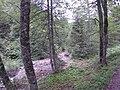
 Sagenbach near the Schwaigeralm |
||
| Data | ||
| Water code | DE : 182132 | |
| location | Upper Bavaria | |
| River system | Danube | |
| source | West slopes of Schinder 47 ° 36 ′ 11 ″ N , 11 ° 50 ′ 54 ″ E |
|
| Source height | 1630 m | |
| muzzle | at Kreuth in the Weißach coordinates: 47 ° 37 '39 " N , 11 ° 44' 59" E 47 ° 37 '39 " N , 11 ° 44' 59" E |
|
| Mouth height | 790 m | |
| Height difference | 840 m | |
| Bottom slope | approx. 84 ‰ | |
| length | approx. 10 km from the source of the Engelsbach . |
|
| Catchment area | 18.8 km² | |
| Left tributaries | Weissenbach | |
| Right tributaries | Write | |
The Sagenbach , on the upper reaches of Engelsbach , is a flowing body of water in Bavaria that flows into the Tegernsee tributary of Weißach from the right before Kreuth .
course
The Engelsbach arises on the western slopes of the Schinders . It first enters a gorge at the foot of the Schinders, but seeps away at its exit at the Langenaualm in the gravel bed of the so-called Langen Au , which fills the valley floor between the Langeckberg on the left and the Lapberg on the right. The stream, which is now called Sagenbach , flows at times , but also here in part openly. The stream only emerges from the gravel bed a few kilometers further west and finally flows into the Weißach after a total of approximately west-north-west running from the right at the bend to the north south of Kreuth.
gallery
Engelsbach before entering the gorge

nameless tributary to the Engelsbach from the southern flank Laubbergel

.jpg)
Individual evidence
- ↑ Roughly measured on the Bavaria Atlas.
- ↑ Catchment area according to: Directory of brook and river areas in Bavaria - Inn river area, page 4 of the Bavarian State Office for the Environment, as of 2016 (PDF; 2.8 MB)
Web links
- The course of the Sagenbach on the BayernAtlas