
Irschenberg
| coat of arms | Germany map | |
|---|---|---|

|
Coordinates: 47 ° 50 ' N , 11 ° 55' E |
|
| Basic data | ||
| State : | Bavaria | |
| Administrative region : | Upper Bavaria | |
| County : | Miesbach | |
| Height : | 731 m above sea level NHN | |
| Area : | 53.91 km 2 | |
| Residents: | 3204 (Dec. 31, 2019) | |
| Population density : | 59 inhabitants per km 2 | |
| Postal code : | 83737 | |
| Primaries : | 08062, 08025, 08064, 08020 | |
| License plate : | MB | |
| Community key : | 09 1 82 123 | |
| LOCODE : | DE ICB | |
| Community structure: | 143 parts of the community | |
| Address of the municipal administration: |
Kirchplatz 2 83737 Irschenberg |
|
| Website : | ||
| Mayor : | Klaus Meixner ( CSU ) | |
| Location of the municipality of Irschenberg in the Miesbach district | ||
  |
||

Irschenberg is a municipality in the Upper Bavarian district of Miesbach . The parish village of the same name is the main town of the community.
The elevation of the same name in the municipality is known for the up to 7% incline / decline of the federal motorway 8 running here .
geography
location
The place Irschenberg lies on a ridge (730 m) on the edge of the Alps and above the Mangfall valley . The federal motorway 8 runs through the municipality. After Bad Aibling is 10 km away, Rosenheim km 20, to Salzburg km 95, after Kufstein km 43, after Miesbach 8 km in the state capital Munich km 46th
In the north, Irschenberg borders the community Weyarn and the Seehamer See, which belongs to this community .
Community structure
There are 143 officially named municipal parts:
- The parish villages of Frauenried , Irschenberg and Niklasreuth
- The Kirchdorf Reichersdorf
- The villages of Buchbichl , Jedling , Loiderding , Oberhasling , Radthal , Schwaig , Wendling and Wöllkam .
- The hamlets Auerschmied , Aufham , Bernrain , Eyrain , Fußstall , Graßau , Grub , Hackling , Haslinger Mühle , Hochholz , Hofreuth , Kirchsteig , Lanzing , Marksteiner , Niederhasling , Obholz , Pfaffing , Pfisterer , Riedgasteig , Rieding , Salzhub , Schlachtham , Schwamham , Sinnetsbichl , Sperlasberg , Windwart and Zieglhaus .
- The wastes deriving , Ahrain , Alb , Angl , Aschbach , Bach , Bäck , mining , Berger , Bichl , Binzerhütte , Brandlberg , fire Instead , Briefer , Brunn moss , book field , Deining , Dessl , Ehgarten , Eichbichl , moths , Fehleiten , Wade , foot , Gasteig , Gehrer , Giglberg , Gmoabauer , Grainholzer , Großhub , Großschönau , Großschwaig , Grund , Grundbach , Harrain , Harraß , Hatzl , Heimatsreut , Heimberg , Heißkistler , Hilgenrain , Hinterholz , Hinteröd , Hofer , Hollerthal , Holzer , Huber , Imbuchs , Immenfeld , Jedlinger Mühle , Kalten , Karlinger , Karrenhub , Kasthub , Katzenberg , Kindler , Kleinhub , Köck , Kogel , Kolmberg , Krinning , Lehermann , Leiten , Lengfeld , Locher , Loder , Moarhof , Moos , Moosbauer , Moosweber , Neuhäusel , Neuradthal , Nussbaum , Oberkretzach , Obermoos , Oed , Offenstätter , Ponlehen , Ponleiten , Poschanger , Reiter , Riedberg , Riedl , Schlosser , Schwibich , Seeried , Sonnenhub , Sporer , Starzberg , Staudinger , Stolzenberg , Streitau , Thal hamer , Unterholz , Unterkretzach , Untermoos , Unterschönau , Wartbichl , Wiedmann , Wienbauer , Wieser , Willenberg , Wilparting and Winastött .
geology
The Irschenberg is the result of debris flows from the upper freshwater molasse that came from the south about 10–15 million years ago when the Alps rose. These coarse cones of rubble today form characteristic mountains in front of the exits of the former tertiary Alpine rivers ( Tischberg , Hoher Peißenberg , Taubenberg, etc.). Due to the ice, they were later carved out of fine sand as hardened ones in relation to their softer surroundings and, like icebreakers, divided the ice flow into individual glacier tongues (praise) (e.g. Tischberg).
history
The place name, formerly “Ursenperig”, is probably derived from the Latin ursus (bear).
In 657, the Irish bishop Marinus and his deacon Anian settled in the current parish in Wilparting and Alb. According to tradition, the two missionaries were martyred in 697, which is a reminder of the Wilparting pilgrimage church, which can be seen from the motorway and is a popular photo opportunity. In 1315 "Ursenperig" was first mentioned as a parish.
In 1934 the construction of the Munich-Salzburg motorway began . In 1950/51 the Irschenberg motorway service station was built with a motel. In the course of the Bavarian territorial reform , the municipalities of Reichersdorf and parts of the former municipalities of Niklasreuth (Niklasreuth, Ahrain, Angl, Aschbach, Bach, Bichl, Briefer, Deining, Ehgarten, Eyergraben, Eyrain, Furt, Fußstall, Großhub, Großschönau) became part of the 1st July 1972 , Grub, Grund, Grundbach, Harraß, Hatzl, Heißkistler, Hilgenrain, Hinterholz, Hofreuth, Kalten, Karrenhub, Kleinhub, Köck, Kolmberg, Kolmbergalm, Lehermann, Lengfeld, Loder, Moos, Moosweber, Neuradthal, Oberkretzach, Offenstätter, Poschanger, Radthal , Riedl, Schlosser, Sinnetsbichl, Starzberg, Streitau, Unterfußthal, Unterkretzach, Unterschönau, Wartbichl, Wiedmann, Wieser, Windwart and Zieglhaus) and Parsberg incorporated on May 1, 1978. In 1978 Neukirchen was reclassified to Weyarn .
Population development
Between 1988 and 2018 the municipality grew from 2,605 to 3,198 by 593 inhabitants or by 22.8%.
politics
Municipal council
The past local elections led to the following allocation of seats in the local council :
| Local election 2014 | Local election 2020 | |||
|---|---|---|---|---|
| Parties and constituencies | Seats | Voting share in% | Seats | Voting share in% |
| CSU | 5 | 31.4 | 4th | 27.3 |
| FWG Irschenberg | - | - | 4th | 26.3 |
| FDP / active citizens | 2 | 13.9 | 3 | 16.3 |
| FW Niklasreuth | 4th | 21.3 | 3 | 16.1 |
| FWG Reichersdorf | - | - | 2 | 13.8 |
| FWG Irschenberg / Reichersdorf | 5 | 33.4 | - | - |
| total | 16 | 100.0 | 16 | 100.0 |
mayor
The professional first mayor is Klaus Meixner (CSU). He has been in office since May 28, 2019. On May 26, 2019, he was elected as successor to Mayor Hans Schönauer, who died on January 31, 2019, from two competitors with a share of 52.37% of the votes.
coat of arms
|
|
Blazon : "kneeling in blue on red flames of the holy Bishop Marinus with gold lined miter and golden measuring dress over silver undergarment." |
Architectural monuments

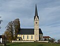
Parish church Irschenberg

St. Anian in Alb
St. Leonhard in Reichersdorf


Others
In 2005 the community was awarded the quality prize of the Bavarian Ministry of Economic Affairs .
literature
- Peter Pfatrisch: History of the parish Irschenberg . In: Upper Bavarian Archive for Fatherland History , Volume 23, Munich 1863, pp. 76–142 ( online ).
- Rolf K. Meyer, Hermann Schmidt-Kaler: On the trail of the Ice Age south of Munich - eastern part , walks in the history of the earth, Volume 8, ISBN 978-3931516093
- Geological map of Bavaria with explanations (1: 500,000). Bavarian Geological State Office, 1998.
Web links
Individual evidence
- ↑ "Data 2" sheet, Statistical Report A1200C 202041 Population of the municipalities, districts and administrative districts 1st quarter 2020 (population based on the 2011 census) ( help ).
- ^ Municipality of Irschenberg in the local database of the Bayerische Landesbibliothek Online . Bavarian State Library, accessed on September 7, 2019.
- ^ History , Irschenberg community, accessed February 4, 2010
- ^ Wilhelm Volkert (ed.): Handbook of Bavarian offices, communities and courts 1799–1980 . CH Beck, Munich 1983, ISBN 3-406-09669-7 , p. 522 .
- ↑ Bavarian State Office for Statistics and Data Processing (Hrsg.): The municipalities of Bavaria according to the territorial status May 25, 1987. The population of the municipalities of Bavaria and the changes in the acquisitions and territory from 1840 to 1987 (= contributions to Statistics Bavaria . Issue 451). Munich 1991, p. 48 , urn : nbn: de: bvb: 12-bsb00070717-7 ( digitized version - Miesbach district; footnotes 2,6 and 7).
- ^ Federal Statistical Office (ed.): Historical municipality directory for the Federal Republic of Germany. Name, border and key number changes in municipalities, counties and administrative districts from May 27, 1970 to December 31, 1982 . W. Kohlhammer, Stuttgart / Mainz 1983, ISBN 3-17-003263-1 , p. 581 .
- ↑ Bavarian State Office for Statistics and Data Processing (Hrsg.): The municipalities of Bavaria according to the territorial status May 25, 1987. The population of the municipalities of Bavaria and the changes in the acquisitions and territory from 1840 to 1987 (= contributions to Statistics Bavaria . Issue 451). Munich 1991, p. 48 , urn : nbn: de: bvb: 12-bsb00070717-7 ( digitized version - Miesbach district; footnotes 6 and 11).
- ^ Local councils. Retrieved March 25, 2020 .
- ↑ Local election 2020 - Municipality of Irschenberg. Retrieved March 25, 2020 .
- ↑ Mayor / Lord Mayor in municipalities belonging to the district (as of May 1st, 2020). (xlsx) Bavarian State Office for Statistics, accessed on June 20, 2020 .
- ↑ Municipal Council. Irschenberg municipality, accessed on August 26, 2020 .
- ↑ Entry on the coat of arms of Irschenberg in the database of the House of Bavarian History
Derive | Ahrain | Alb | Angl | Aschbach | Auerschmied | Aufham | Bach | Back | Miner | Berger | Bernrain | Bichl | Binzerhütte | Brandlberg | Brandstatt | Letter | Brunnmoos | Buchbichl | Buchfeld | Deining | Deßl | Ehgarten | Eichbichl | Eyrain | Moth | Misdirection | Frauenried | Ford | Foot | Foot stall | Gasteig | Gehrer | Giglberg | Gmoabauer | Grainholzer | Graßau | Large stroke | Großschönau | Großschwaig | Grub | Reason | Grundbach | Hackling | Harrain | Harraß | HaslingerMühle | Hatzl | Heimatsreut | Heimberg | Hot kistler | Hilgenrain | Backwood | Hinteröd | Tall wood | Hofer | Hofreuth | Hollerthal | Holzer | Huber | Imbuchs | Immenfeld | Irschenberg | Jedling | JedlingerMühle | Cold | Karlinger | Cart lift | Kasthub | Katzenberg | Kindler | Kirchsteig | Small stroke | Köck | Kogel | Kolmberg | Krinning | Lanzing | Lehermann | Guide | Lengfeld | Hole punch | Loder | Loiderding | Marksteiner | Moarhof | Moss | Moosbauer | Moss weaver | Neuhäusel | Neuradthal | Niederhasling | Niklasreuth | Walnut | Oberhasling | Oberkretzach | Obermoos | Obholz | Oed | Offenstätter | Pfaffing | Pfisterer | Ponlehen | Ponleiten | Poschanger | Radthal | Reichersdorf | Rider | Riedberg | Riedgasteig | Rieding | Riedl | Salt lift | Slaughterhouse | Locksmith | Schwaig | Schwamham | Schwibich | Seeried | Sinnetsbichl | Sun lift | Sperlasberg | Sporer | Starzberg | Staudinger | Stolzenberg | Streitau | Thalhamer | Undergrowth | Unterkretzach | Untermoos | Unterschönau | Wartbichl | Wendling | Wiedmann | Wienbauer | Wieser | Willenberg | Wilparting | Winastött | Windwart | Wöllkam | Brick House

Bad Wiessee | Bayrischzell | Fischbachau | Gmund am Tegernsee | Hausham | Wooden churches | Irschenberg | Kreuth | Miesbach | Otterfing | Rottach-Egern | Schliersee | Tegernsee | Valley | Waakirchen | Warngau | Weyarn