
Rosenheim
| coat of arms | Germany map | |
|---|---|---|

|
Coordinates: 47 ° 51 ' N , 12 ° 8' E |
|
| Basic data | ||
| State : | Bavaria | |
| Administrative region : | Upper Bavaria | |
| Height : | 447 m above sea level NHN | |
| Area : | 37.22 km 2 | |
| Residents: | 63,551 (Dec. 31, 2019) | |
| Population density : | 1707 inhabitants per km 2 | |
| Postcodes : | 83022, 83024, 83026 | |
| Area code : | 08031 | |
| License plate : | RO | |
| Community key : | 09 1 63 000 | |
| LOCODE : | DE ROS | |
| NUTS : | DE213 | |
| City structure: | 30 districts | |
City administration address : |
Königstrasse 24 83022 Rosenheim |
|
| Website : | ||
| Lord Mayor : | Andreas March ( CSU ) | |
| Location of the city of Rosenheim in Bavaria | ||
 .svg) |
||


The independent city of Rosenheim is located in the administrative district of Upper Bavaria in the foothills of the Alps , at the confluence of the Mangfall and Inn rivers . It is enclosed by the district of Rosenheim and at the same time its administrative seat. With around 63,000 inhabitants, Rosenheim is the third largest city in Upper Bavaria after Munich and Ingolstadt and one of 23 Bavarian regional centers .
geography

Geographical location
Rosenheim is located in the Inn Valley at an altitude of 446 m . The Mangfall , the Sims and the Rohrdorfer Achen flow into the Inn in the urban area . The Chiemgau extends to the northeast, to the southeast the terrain rises towards the Chiemgau Alps and southwest to the Mangfall Mountains .
The city is an important traffic junction between Munich (approx. 60 km northwest), Salzburg (approx. 80 km east) and Innsbruck (approx. 110 km southwest) as well as the Brenner Pass to Italy (approx. 130 km). The railway lines Munich – Salzburg and Munich – Verona / Italy as well as the Austrian railway transit line Salzburg – Innsbruck run through Rosenheim . Near the city lies the motorway Inntal , where the Inn Valley motorway from the motorway between Munich and Salzburg branches (see also transport ).
The place has a high recreational value due to its location; In the immediate vicinity of about 25 km are the Chiemsee , the Simssee and about a dozen other bathing lakes as well as the mountains of the northern edge of the Alps, Wendelstein , Hochries and Kampenwand , which are ideal for skiing, hiking, mountain biking and paragliding / hang-gliding .
geomorphology
The landscape immediately around Rosenheim was shaped in its current form in the last Ice Age by the Inntal Glacier . The city is located in the Rosenheim basin on the bottom of a former glacial lake that stretched as far as the Wasserburg am Inn area around 10,000 years ago , a good 25 km north of Rosenheim; the Simssee , 7 km east of Rosenheim is a last remnant. Even today you can see in many places around the city how the former flat lake bed abruptly merges into the relatively steep embankment.
Neighboring communities
| Großkarolinenfeld | Schechen | |
| Kolbermoor |
.svg)
|
Stephanskirchen |
| Raubling | Rohrdorf |
City structure
Rosenheim is divided into the 9 districts city center, west, east, south, Fürstätt, Westerndorf St. Peter , Happing , Aising and Pang .
In addition, there is a subdivision into 30 parish parts:
|
South (of the railway line): |
|
North (of the railway line):
|
The places Endorferau and Kastenau are not officially named.
climate
The city is located in the temperate climate zone . The average annual temperature in Rosenheim is 9.4 ° C. The warmest months are July and August with an average of 17.2 and 18.9 ° C and the coldest December and January with an average of -0.3 and -0.9 ° C. The annual precipitation of 1310.6 mm is well above the overall German average of 700 mm.
|
Climatic data of Rosenheim
Source: Maximum and minimum temperatures & rainfall:
Sunshine hours: Water temperature: Rainy days: |
|||||||||||||||||||||||||||||||||||||||||||||||||||||||||||||||||||||||||||||||||||||||||||||||||||||||||||||||||||||||||||||||||||||||||||||||||||||||||||||||||||||||||||||||||||||||||||||||||||||||||||||||||||||||||||||||||||||||||||||||||||||||||||||||
history
Already in the Middle Ages, the city was a traffic intersection and business location , received market rights early on and developed from a salt and railroad town into today's timber and technical college town. The location on the important traffic axes was decisive for the development of the place.
Pons Aeni
The Inn and the associated Inn Valley were decisive for the settlement of the area . As early as 15 BC The Romans came to this place under the leadership of Drusus and Tiberius . They founded there the right of the Inn, the province of Noricum , left the Inn Rätien . The colonizers then built a consular road from Brenner to Castra Regina (Regensburg) and a road running in an east-west direction from Iuvavum (Salzburg) to Augusta Vindelicum (Augsburg). The intersection of these two important trade routes was protected by a military station. Their name was "Pons Aeni" (dt. Inn bridge ). Seldom used names were "Ponte Aoni", "Ad Enum" or "Statio Enensis". The Roman-Celtic settlement of the Roman occupation , which lasted around 500 years, took this name. Pons Aeni was between Isinisca ( Aying ) and Bedaium (Seebruck), as the Roman street directory Itinerarium Antonini and the Roman street map Tabula Peutingeriana from the 4th century show. In the course of time, due to the language of the Bavarians , “Pons Aeni” developed into “Pfunzen”, which is still common today and which still exists in the district names “Langenpfunzen” and “Leonhardspfunzen”.

Origin of the city name
The origin of the city name is not clear. Rosenheim Castle on the eastern bank of the Inn, on today's Schlossberg, above a new bridge over the Inn, is first mentioned in 1234 . The name Rosenheim probably goes back to the rose coat of arms of the Wasserburg Hallgraves, who built the castle. Another theory says that the name was originally Rossenheim , derived from the steeds that were used in the Middle Ages to pull transport ships up the river, and for which there were large stables in Rosenheim. Street names that are still used today, such as Am Esbaum (the tree on which the horses branch) or Am Roßacker are a possible reference to this. Another clue that supports this theory is the map of the region in Palazzo Vecchio, on which the city is referred to as "Rossenheim".
Another theory says that there could also be a relationship between the words Roas , Roze or Ried , which used to refer to swamp and peat areas that can still be found around Rosenheim today - also clearly evident from the name of Rosenheim's neighboring town Kolbermoor . An example of one of the old names is the nearby town of Riedering . The name Rosenheim may also be derived from the personal name Roso / Hrodo .
Literally the most beautiful theory is that beautiful girls used to be called 'rose'. Even the Inn boaters believed that this city had a particularly large number of beauties to admire. The town, which the boatmen like to head for, was given the name “home of roses” - in other words Rosenheim.
Origin of Rosenheim
Around the time the castle was first mentioned in 1234, Rosenheim was built in the 13th century on the western bank as a settlement for shipmen. Since the area at the Inn Bridge could not be built on for a long time due to the marshy soil in the course of the Mangfall estuary, the settlement was built a few hundred meters away. The city center of Rosenheim is therefore not directly on the river bank.
Rosenheim market

The place quickly gained importance as a transshipment point for all types of goods that were transported on the Inn (cattle, grain, silk, weapons, salt) and received market rights in 1328 . The Rosenheim shipmasters achieved great wealth in this epoch due to the lively transport of goods that stretched between Hall in Tirol, down the Inn and Danube to Vienna and Budapest . By around 1600 the settlement had developed into one of the largest and most important markets in Bavaria.
The economic decline came in the course of the 17th century as a result of the decline in shipping on the Inn and the consequences of the Thirty Years' War . There was also a plague epidemic (1634) and a market fire (1641).

In the 19th century, Rosenheim was able to develop into an economic center in south-eastern Bavaria: in 1810, after Reichenhall and Traunstein , the town became the site of the third Bavarian saltworks . An early type of pipeline made of wood brought brine from the salt mines in the Reichenhall area to the Rosenheim saltworks. By boiling salt, the Innstadt became a center of Bavarian salt production until the saline was closed in 1958.
The early connection to the railroad brought a further upswing. In 1858 the Rosenheim train station was inaugurated, but it soon turned out to be too small and a hindrance to further urban development; in 1876 it moved to its present location. The old railway line became a dead straight thoroughfare (today Rathausstrasse and Prinzregentenstrasse, the most important traffic axis in Rosenheim, from the northwest to the southeast of the city), the locomotive shed at the first station is now an exhibition center, the old station directly opposite has been the city hall since 1878 - and serves as the backdrop for the police headquarters in the ZDF evening series " Die Rosenheim-Cops " .
City of Rosenheim
Rosenheim was not granted city rights until 1864 by King Ludwig II. The acquisition of city rights was announced on October 2, 1864 in the "Rosenheimer Anzeiger" (issue no. 40).


The economic heyday of the late 19th and early 20th centuries made the Wilhelminian style and Art Nouveau (and its regional characteristics, the Heimatstil ) the most important architectural style that still defines the cityscape today. The evangelical Church of the Redeemer was built in the neo-Gothic clinker brick style, which is rare for Rosenheim, for the growing Evangelical Lutheran congregation in the official district around today's town hall.
At the beginning of the 20th century, Rosenheim owned nine breweries, which are preserved today in the name of a few restaurants (Duschl-, Hof-, Mail-, Pernloher-, Stern-, Weißbräu). Only Auerbräu and Flötzinger Bräu have survived to this day . a. deliver the Märzenbier for the Rosenheim autumn festival , as well as the B. Bierbichler Weißbräu.
Five therapeutic baths were built in the city, none of which are in operation today: the Old Bath (officially renamed the Kaiserbad in 1885 ), the Marienbad , the Dianabad , the Bismarckbad and the Mineralbad zur Leonhardsquelle . The first German Emperor, Wilhelm I, stayed seven times in the Alte Bad and twice in Marienbad. In 1985 the Kaiserbad was canceled.

Imperial bath around 1910

Preserved portal of the Imperial Bath (2011)

Former Marienbad (2017)


Rosenheim during the time of National Socialism
After the First World War, Rosenheim was one of the centers of revolution and council rule in Bavaria .
Anti-Semitism from 1900 to the time of National Socialism
The number of Jews living in Rosenheim was high compared to other Bavarian cities. However, although the Jewish community at the turn of the century comprised around 50 people, the application for the establishment of a separate Israelite religious association was refused by the city council with reference to the Bavarian Jewish legislation, so that the Rosenheim Jews remained connected to the state capital and buried their dead there had to. Even the burial of the son of a Jewish merchant who lived in Rosenheim, who died in World War I, was not allowed to be buried in the town's honorary cemetery, "to the greatest disappointment and bitter pain" of the father.
At the latest with the establishment of the first local NSDAP group outside of Munich in 1920, the Rosenheim Jews were increasingly exposed to hostility. The center of the smear campaigns was the high school in Rosenheim . So there was a scandal in June 1920 after the writer of a letter to the editor accused the Rosenheim Jews in the local press of wanting to betray the Entente military exercises that were taking place against the provisions of the Versailles Treaty at the Rosenheim Gymnasium. Seven members of the grammar school and one member of the “Chiemgau” raided a villa in Herbststrasse inhabited by Jews, but were unable to storm it. The college of Rosenheim came to the decision on July 29, 1920, "... it is regrettable that the movement to fight against the exploitative Jewry [...], which in its essence is certainly justified, is discredited by such excesses." Protests of the Bavarian Israelite Central Association remained unsuccessful, only an unmistakable message from the Bavarian Ministry of the Interior in September 1920 could bring about peace again.
On April 1, 1933, shortly after the NSDAP came to power, guards were set up in front of Jewish shops with the task of warning against buying in these shops, but with the stipulation that they would refrain from attacks and damage to property. However, a large part of the population ignored these calls. The shops were therefore still frequented, much to the annoyance of the Nazi activists, who acted with the backing of the then Mayor Gmelchs. Six of the eleven Jewish business owners in the city center had given up their business by 1937. As part of the nationwide November pogroms , the SA broke into the last two Jewish shops on November 10, 1938 between 3 and 4 a.m. with 8 to 10 men and destroyed inventory and goods.
The fate of numerous Rosenheim Jews is documented. Those who could emigrated - mostly to the USA. However, many exit and entry applications failed and many were murdered in concentration camps.
Bombardment during World War II
Rosenheim was not spared from the bombing raids on German cities that began in spring 1942. For the then city population of around 22,000 people, only air raid shelters for 650 people were available in November 1943 . In February 1944, however, air raids were already available for around 6,400 people; in connection with other shelters, a total of 10,525 people could be protected.
201 people were killed and 179 injured in 14 bomb attacks. The focus of the air raids was on the train station and the tracks, as Rosenheim was an important railway junction to Munich, Salzburg and Innsbruck. The neighboring communities of Ziegelberg, Stephanskirchen, Westerndorf St. Peter and Pfaffenhofen am Inn were also hit. The first air raid took place on October 20, 1944 at noon from 12:47 p.m. to 1:17 p.m. with over a hundred aircraft dropping around 1,000 explosive bombs. 27 dead and 59 wounded were counted. The heaviest air raid took place on April 18, 1945. From 14:40 to 14:55, around 1,300 bombs from around 200 aircraft fell into the area around the station. There were 53 dead and 36 injured; in addition, this attack also left 800 people homeless. The station building was almost completely destroyed, track systems were destroyed over a length of 20 kilometers. The last air raids took place on April 19 and 21, 1945. Most of the at least 173 duds were recovered during the war. In 1964 the Upper Bavarian Volksblatt reported that the approximate location of 38 undiscovered duds was known.
|
Incorporations
Happing has been part of the city since July 1st, 1967.
On May 1, 1978, as part of the community reform , the urban area was expanded to include the previously independent community of Aising and significant parts of the dissolved communities of Pang and Westerndorf St. Peter, which was renamed on September 26, 1951 (previously: Westerndorf ). On July 1, 1980, a small area of the Kolbermoor municipality was added.
Demographics
| year | population | Remarks |
|---|---|---|
| 1808 | 1,600 | |
| 1815 | 2,240 | |
| 1824 | 1.937 | 454 families, 234 houses, counted in the administrative year 1823/24 of the Isarkkreis |
| 1840 | 3,100 | |
| 1855 | 3,100 | |
| 1861 | 4.140 | |
| 1871 | 5,779 | in 646 residential buildings, 5,584 Catholics, 193 Protestants , one Reformed , one Israelite |
| 1875 | 7,501 | |
| 1880 | 8,397 | |
| 1900 | 14,246 | of which 772 Evangelicals, 13,421 Catholics |
| 1905 | 15,403 | mostly Catholic residents, including 800 Protestants and 45 Jews |
| 1910 | 15,969 | thereof 690 Evangelicals, 15.202 Catholics |
| 1925 | 17,998 | thereof 947 Evangelicals, 16,937 Catholics, 30 other Christians and 39 Jews |
| 1933 | 19,060 | thereof 1,146 Evangelicals, 17,790 Catholics, four other Christians and 38 Jews |
| 1939 | 20,692 | 1,430 Protestants, 18,742 Catholics, 45 other Christians and seven Jews |
| 1946 | 27,979 | in June, population growth due to displacement after the end of World War II |
| 1949 | 30,510 | |
| 1950 | 29,937 | |
| 1960 | 31,100 | 7,200 of them displaced |
| 1970 | 46,018 | |
| 1988 | 54,304 | |
| 2010 | 61,299 | On the 31st of December |
| 2011 | 59,329 | on May 9th (censorship date) |
| 2018 | 63,324 | since 1988 an increase of 16.6% |

After the end of the Second World War , Rosenheim experienced a considerable increase in population as a result of the expulsion of the Germans from the eastern regions of the German Empire . Most of the displaced persons who had to be taken in Rosenheim came from the Sudetenland and Silesia .
The residents' office of the city of Rosenheim puts the population at the end of 2015 at 62,324, of which 12,279 are foreigners. Between 1988 and 2018 the independent city grew from 54,304 to 63,324 by 9,020 inhabitants or by 16.6%.
What is remarkable is the population of around 162,000, more than two and a half times as high in the urban agglomeration whose center is Rosenheim. The three cities of Rosenheim, Kolbermoor and Bad Aibling are directly adjacent to one another in one line.
Rosenheim is the third largest city in Upper Bavaria after Munich and Ingolstadt and, in contrast to the other cities, still has a majority Catholic population.
politics
City council
The city council with a total of 44 seats is composed as follows:
* Die Linke / mutBayern / Piraten / The Party / V-Party³ Of 46,511 eligible voters, 22,076 voted. The voter turnout was 47.5%. There were 85 electoral districts. |
45,592 citizens were eligible to vote and the turnout was 40.81%. There were 80 constituencies. (As of April 3, 2014) |


mayor
Andreas März (CSU) has been Lord Mayor of Rosenheim since May 2020. In a runoff election on March 29, 2020, 61.5% of the votes cast against Franz Opperer (Greens), he was elected to succeed Gabriele Bauer , who after 18 years in office did not stand for re-election in the 2020 local elections for reasons of age.
| Lord Mayor : | Andreas March (CSU) |
| 2nd Mayor: | Daniel Artmann (CSU) |
| 3rd Mayor: | Gabriele Leicht (SPD) |
coat of arms
|
|
Blazon : "In red, a fallen, silver heraldic rose with a smaller, green-tipped, silver rose (filled rose), a golden slug and green sepals." |
| Justification of the coat of arms: The white rose on a red background can be traced back to the former coat of arms of Wasserburg am Inn , since Wasserburg Rosenheim ruled until 1247. The oldest known seal of the city of Rosenheim dates from 1374 and already shows the rose, which has not been changed until today. The only exception is a picture by Apian , which was created around 1568 and shows a border around the rose. |
On older coats of arms the outer rose is regular, the superimposed filling rose overturned.
In addition, there has been a logo for the city of Rosenheim for some time. The rose, which is also present on the coat of arms, can be found on it.
Town twinning
Rosenheim maintains the following city partnerships :
-
 Briançon ( France ), since 1974
 -
 Lazise on Lake Garda , Italy , since 1979
 -
 Ichikawa ( Japan ), since 2008
Rosenheim is friends with:
Culture and sights

theatre
The Rosenheim Culture and Congress Center (KU'KO) was built on the site on which the salt works were demolished in 1967 . The town hall, inaugurated on October 2nd, 1982, today's Rosenheim culture and congress center, has developed over the years into a national event center. Around 400 events are held annually in the multi-purpose building, which is 3,000 square meters in size. There are two private theaters with their own houses: the “Theater am Markt Ost” and the “Theaterinsel”, as well as the “Theater Rosenheim”, “INNszenierung” and other amateur theaters.
Museums
Since 1885 the Mittertor has housed the municipal museum with its extensive collection (approx. 5000 exhibits) on the cultural history of the city and the district of Rosenheim from prehistory and early history and Roman times into the 20th century. It is one of the most important collections of regional history in Southeast Upper Bavaria.
The Inn Museum in the historic River Master -Bruckbaustadel at the Inn Bridge is home to the river engineering and navigation technology collection of the Water Management Office Rosenheim. With many original objects the museum shows the Inn shipping, the source of Rosenheim's prosperity in the Middle Ages, in the past centuries. In addition, the museum provides interesting information about the river landscape and river engineering, geology, settlement history, shipbuilding technology, bridge building and the development of waterways.
The wood technology museum was established in 1990 in the listed Ellmaierhaus. It is located on the first floor, which can be reached via the so-called heavenly ladder . On more than 400 square meters of exhibition space, this unique museum, which is closely related to the wooden city of Rosenheim and its training centers for wood professions, shows wood as a material, its importance and processing then and now. Not only the end products are shown, but also their manufacture and the tools required for them. Regular special exhibitions round off the offerings of the Wood Technology Museum.
The Städtische Galerie was built by German Bestelmeyer from 1935 to 1937 . Six art exhibitions take place here every year. In addition to contemporary art, exhibitions with works from the 19th and 20th centuries are shown. One thematic focus is art from the region and the Munich school .
The Lokschuppen is an internationally renowned exhibition center with annually changing exhibitions.
The brine pump house is one of the few architectural monuments in the city that are reminiscent of the Rosenheim saltworks from 1810 to 1958. As part of the state exhibition Salt Power History , the city had the listed building renovated and set up an exhibition room on the history of the Rosenheim saltworks. Access is only possible as part of city tours or by agreement with the Municipal Museum.
The Klepper folding boat museum houses various exhibits that show the history of Klepper boats , coats and tents. On the other hand, it is also dedicated to the career of the Klepper Faltbootwerft company , which was once the city's largest employer.


Buildings
City center squares and buildings
Max-Josefs-Platz - formerly the Inner Market and Schranne - became a pedestrian zone in 1984. The historic market square is surrounded by town houses in the typical Inn-Salzach style (raised, horizontally closed facades; arcades; bay windows). The houses were built after the great fire of 1641. Most of them date from the 14th century. Previously narrow wooden houses have been combined to form stately patrician houses. The pub sign on the Stockhammer house shows a ship train. The Fortner "Zum Santa" wine house was redesigned in the Gothic style in 1642 and given early Rococo stucco in 1745 . There is a Gothic vault in the wine bar. House No. 22 was Rosenheim's town hall from 1641 to 1878. In front of the Bergmeister house, with a rococo entrance door that is well worth seeing, there is a fountain with the late rococo statue of St. Nepomuk, patron saint of shipmen.

Ludwigsplatz is separated from Max-Josefs-Platz by the Mittertor. It was part of the so-called outer market, which was created as a result of the expansion of Rosenheim after 1500. The square is lined with town houses in the Inn-Salzach style. The Fischbrunnen, a work by Georg Albertshofer from 1928, is a reminder that live fish used to be sold here. At the Reindl shoe store, a ball from the Napoleonic era bears witness to a warlike event in 1810. The green market with a wide range of fresh fruit, vegetables and flowers takes place regularly on part of the square. Ludwigsplatz was renewed in the course of the State Garden Show 2010.
The Mittertor is the only one of what used to be five market gates and was the east gate of the market before 1350, which was then protected by a double moat. Since the 15th century it separated the Inner Market from the Outer Market and served as a customs post. It also contained several municipal facilities such as the town clerk's room until the 19th century . After the great fire in Rosenheim in 1641, the onion dome was added and the long building was later extended. At its core, the Mittertor is the oldest building in the city. On the facade on the Ludwigsplatz side is the coat of arms of Rosenheim, the white rose on a red background. The Bavarian coat of arms can also be seen.
On the Salzstadel north of the Ludwig place since 1559, the Salt House, the storage of the of were hemmers served zoom transported salt. They were destroyed by fire in 1889. The Ballhaus Rosenheim further east was built in the former building complex of the Hofbräus Rosenheim. The hall building with ballroom and vaulted cellar was built in 1878. It was renovated from 1994 and has been available again as an event space since 2001 and, with its diverse uses, forms a center of the eastern old town of Rosenheim.
To the south of Ludwigsplatz is Königstrasse. When the old train station was relocated in 1878, its reception building became the new town hall; the locomotive shed opposite today serves as an exhibition center . The three-storey middle pavilion of the town hall with a tent roof and the two-storey side wings still indicate the old function of the building. In 1858 the building was completed after three years of construction. The Königschule is also located on Königstraße and was built in 1866 as a boys school in Maximilian style according to plans by Ludwig Foltz and Rudolf Gottgetreu .
To the south of Max-Josefs-Platz, along the Gillitzerblock, Münchener Straße, also known as the “small pedestrian zone”, leads towards the train station and Salinplatz. The magnificently restored Wilhelminian style facades are immediately visible . The ensemble owes the name Gillitzerblock to its builder Thomas Gillitzer. At the end of the 19th century he had 15 houses built on what was then a huge area, including the Hotel Deutscher Kaiser . From the 1960s, the once self-contained Gründerzeit ensemble was changed through new buildings and renovations. Only the facades in Münchener Strasse have been preserved and have been faithfully restored in recent years.
More recently, the Salinplatz is nearby. After the demolition of the salt works in the 1960s, a completely new residential and business district was created with apartment blocks and high-rise buildings not far from the new train station. In the 1980s, u. a. Today's town hall (KUKO) was also built. With a planning period of eight years between 1985 and 1987, the Salinplatz was built in just 18 months on an area of 12,000 m² with its residential and commercial buildings and a large underground car park (P6). Salinplatz is a pedestrian zone.
The art mill south of the station was built from 1855 to 1916 in several construction phases as an industrial complex. It was renovated in the 1990s and is now used as a restaurant or office. The power station for the art mill is located on the Mangfall Canal. The art mill houses the exhibition rooms of the Rosenheim art association. On the upper floor of the former art mill, changing exhibitions by contemporary artists, exchange exhibitions with other art associations and activities accompanying the exhibition take place on around 200 m² of exhibition space.
The Loreto Meadow in the north of the old town serves as a free large car park near the city center (P5) for most of the year. The so-called "fifth season", the Rosenheim Autumn Festival , begins on the last Saturday in August on the Loreto meadow .
Churches
The parish church of St. Nikolaus on Ludwigsplatz was built in 1450 as a late Gothic building with a pointed helmet tower. After the town fire of 1641, the new building with an onion dome (65 m) took place - today's landmark of Rosenheim. The interior was changed several times in line with contemporary tastes. H. the church has a baroque or neo-Gothic interior. In 1880 the nave was extended by three bays towards Ludwigsplatz. From 1960 the interior of the church got its present appearance. The oldest work of art is the protective mantle Madonna picture by an unknown master from 1514. The church was reopened on December 10, 2006 with an altar consecration after several years of renovation.
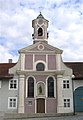
The Hl.-Geist-Kirche west of Max-Josephs-Platz in the street of the same name was built around 1449 by the citizen and brewery owner Hans Stier (hospital foundation). The Gothic building was baroque from 1684 and the tower, which originally had a Gothic pointed helmet, received a Baroque onion. Inside the Wolfgang Chapel is the Lucca picture, a Secco painting from the 15th century.
The St. Joseph Hospital Church in Innstrasse east of Ludwigsplatz was built in 1618/19. It has a rococo pulpit with richly carved decoration. The altarpiece, as well as the other paintings depicting the life of St. Joseph, were made by the Rosenheim painter Joseph Anton Höttinger. The large votive painting, which shows the Pandur invasion and the bombardment of Rosenheim in October 1744, is worth seeing .
The Loreto Chapel on the Loreto Meadow has the Casa Santa in Loreto in Italy as an architectural and name model. It was inaugurated in 1636. Loreto chapels were built in the German-speaking area from the 16th century - often as donations for noble pilgrims after their return from a Loreto pilgrimage.
The parish and pilgrimage church of the Holy Blood , which is located on the southern outskirts of the city, was built in its current form towards the end of the 17th century, the late Gothic choir around 1508. In 1686/1687 the church was rebuilt in baroque style by Hanns Mayr from Hausstatt. In the choir there is lavish high baroque stucco, the stucco in the nave is much more economical. The centerpiece of the church is the late Gothic carving of the heavenly mercy seat, a major work by the master von Rabenden from around 1510. Next to the church is the well chapel, which was built by Hanns Mayr in place of the older one at the end of the 17th century.
The chapel at Roßacker had the Rosenheim brewer Martin Butterer built in 1737 under the name To the seven refuge on the basis of a vow right next to his beer cellar. To this end, he donated a hermit baptism with a house attached to the chapel. The builder was Abraham Millauer from Hausstatt. The master of the natural stone high altar is unknown, the altarpiece is by Johann Zick and depicts the seven holy refuges. The church gem is the only self-contained baroque church in Rosenheim. The "Roßacker" district is older than Rosenheim. The name goes back to 1160.

The Evangelical Church of the Redeemer was built next to the town hall in 1886 as a neo-Gothic brick building based on a design by August Hartel . The furnishings are partly neo-Gothic and were redesigned in the 1970s. The Stations of the Cross are by Petra Winterkamp.
The parish church of Christ the King was approved by the Archbishop's Ordinariate on June 12, 1928 because of the poor pastoral situation at the time, and the first groundbreaking took place five days later. The solemn church consecration took place on October 27, 1929. Due to the destruction of large parts of the church during the Second World War , it received a new glass window by Roland Peter Litzenburger in 1962 , and in 1984 the chancel was redesigned with works by the Rosenheim artist Ludwig Hamberger.
The Capuchin Monastery of Rosenheim , founded in 1606 and repopulated in 1856, is next to the Sebastianikapelle .
The branch and pilgrimage church of St. Johann Baptist and Holy Cross in Westerndorf was probably built in 1668 according to plans by the Munich builder Constantin Pader . An onion roof, visible from afar, sits on the circular church building. Inside, the quadrilateral plan is formed by a Greek cross with cross arms of equal length. Walls and ceilings are decorated with early baroque stucco of Miesbach origin.

left: St. Nikolaus parish church , right: Heilig-Geist-Kirche, in the background the Kampenwand
Chapel on the Roßacker

Parish Church of St. Joseph the Worker, Oberwöhr


Facilities
The Rosenheim City Library (am Salzstadel) was opened in 1996 in the building of a former malt house. It offers books, magazines, CDs, CD-ROMs and other media on around 1200 m². In the category of medium-sized town libraries (50,000-100,000 inhabitants) reached the city library Rosenheim several times the first place the library index .
The city archive has been located in a side building of the city gallery since 1937. After being extensively updated, it currently houses around 2500 meters of shelves for files, plans, certificates, maps and the like. The archives and the regional scientific library can be used by anyone free of charge. As a Bavarian pilot project on archival education, the city archive offers special exhibitions, lectures, readings, and guided tours for school classes and interested groups as well as support for specialist work. A reading room offers space for 30 people as well as PC workstations with internet connection.
| Surname | Artist |
|---|---|
| water wheel | Josef Hamberger |
| Standing | Rolf Märkl |
| Lying | Marianne Lüdicke |
| Man and horse | Heinrich Kirchner |
| Norn | Louise Stomps |
| Passerby group | Erika Maria Lankes |
| stele | Alfred Regnat |
Parks

All year round, contemporary three-dimensional works of art by the Rosenheim artists' association can be seen on the Kunstwiese.
The Riedergarten was created in 1729 as a private herb garden for the Rosenheim city pharmacist Johann Rieder. It was sold to the city as a summer garden in 1925 by the physician Hermann Rieder . In 2002 the Riedergarten was redesigned and received a modern character by opening the previously underground Stadtbach.
Since 1987 the Salingarten in front of the Ku'Ko Culture and Congress Center has become a sculpture park in which large sculptures by important sculptors from Rosenheim and the surrounding area can be seen.
Protected areas
In Rosenheim there is a nature reserve , three landscape protection areas and an FFH area (as of April 2016)

State Garden Show 2010
The city of Rosenheim hosted the State Garden Show 2010 . In the course of this event, major renovations in the city center as well as at Mangfall and Inn have reshaped the cityscape. The train station was also rebuilt so that it is barrier-free and has more shops and facilities.
Sports
Rosenheim has a long ice hockey tradition. The beginnings of ice hockey go back to 1928. This means that Rosenheim, together with Füssen, Garmisch-Partenkirchen and Bad Tölz, is one of the oldest ice hockey locations in Bavaria. The Sportbund DJK Rosenheim (SBR) became German champions in 1982, 1985 and 1989 and reached the final of the German championship in 1988, 1990 and 1992. In 1993 he was voluntarily relegated to the second Bundesliga. With a team formed from their own offspring, they were immediately promoted back to the first division. In 1994 the first Bundesliga was converted into the DEL , of which the SBR was one of the founding members. The ice hockey department was split off from the parent club Sportbund DJK Rosenheim and converted into Starbulls Rosenheim GmbH . After several years in the DEL, the license was sold to Iserlohn. The club had to be called Starbulls Rosenheim e. V. start all over again in the lowest Bavarian league, but made it to the top division (third highest division) in the 2003/2004 season and to the 2nd Bundesliga in the 2009/2010 season. In the 2010/2011 season, the DEB Cup was won for the first time in the club's history. In 2011/2012 he was runner-up in the 2nd Bundesliga.
The Starbulls Rosenheim attach great importance to youth ice hockey work. The flagship here is the DNL team, which won the German runner-up in the 2005/06 and 2010/11 seasons.
Rosenheim's largest of a total of eight football clubs is TSV 1860 Rosenheim , whose first team currently plays in the Bavarian Regional League. The team became champions of the Landesliga Süd in 2009 and has been playing in the Bavarian Regional League since the 2009/10 season. TSV plays its home games in the Jahnstadion , which opened in 1969 .
The members of the Rosenheim Kayak Club (KKR) achieved international success. Even world and European champions (for example Claudia Brokof) emerged from the ranks of this club and KKR athletes are currently among the top international.
The Rosenheim section of the German Alpine Club , founded on September 23, 1877, is the largest sports club in town, has two shelters and its own climbing center ; She also looks after several kilometers of high-altitude trails .
The top German and partly international athletes also include athletes in the disciplines of badminton (PTSV Rosenheim), boxing (ASV Happing), athletics (TSV 1860 Rosenheim), fistball (MTV Rosenheim), rock'n'roll dance (rock ' n'-Roll-Club Rosenheim) as well as skiers / snowboarders and martial artists from several clubs. The PTSV Rosenheim and its badminton team were promoted to the 1st Bundesliga in 2010.
The four popular sports clubs in Rosenheim with the largest number of members are the Rosenheim section of the German Alpine Club, SB / DJK Rosenheim, the Aising-Pang ski club and TSV 1860 Rosenheim.
The largest sports facilities in Rosenheim are the municipal ice stadium Rofa-Stadion , which has 6,300 spectators, the Gabor-Halle (1,200 places) as well as the Jahnstadion (6,000 places) of TSV 1860 Rosenheim and the campus of the SB / DJK Rosenheim.
Regular events
- Rosenheim Strong Beer Festival (mid-March)
- Rosenheim City Festival (between June and August; every two years)
- The Rosenheim Autumn Festival (start: last Saturday in August, duration: 16 days) is the largest folk festival in southeast Upper Bavaria. With over a million visitors a year, it is the fourth largest festival in Bavaria after the Munich Oktoberfest , the Straubing Gäubodenfest and the Bergkirchweih in Erlangen .
- New Messe Rosenheim (every two years): The south-east fair has been taking place in Rosenheim since 1949; in 2008 it was replaced by the Neue Messe Rosenheim
- City run (October 3rd)
- Christmas market in the pedestrian zone (from the Friday before the 1st of Advent to December 24th)
- Mardi Gras (every Shrove Tuesday)
- Rosenheim on the move (May) with a large car salon, leisure theme park, fun & fitness , shopping Sunday u. v. m.
- Critical Mass : Bike tour through the city (every last Saturday of the month, departure 11.55 a.m. at Ludwigsplatz)
- Long night of art, culture and entertainment (every two years in autumn, alternating with the city festival)
- Cabaret Days (mid-October)
- Rosenheim Summer Festival (July, since 2011)
- City tour "In the footsteps of the Rosenheim cops" (every Saturday at 4 p.m.)
- City cycling (campaign of the climate alliance of European cities with indigenous peoples of the rainforests / Alianza del Clima e.V with the subtitle cycling for a good climate )
Economy and Infrastructure

In 2016, Rosenheim achieved a gross domestic product (GDP) of € 3.091 billion within the city limits . In the same year, GDP per capita was € 49,671 (Bavaria: € 44,215 / Germany € 38,180) and thus well above the regional and national average. In 2017 there were around 48,600 employed people in the city.
In the future atlas 2016 , the independent city of Rosenheim took 88th place out of 402 districts, municipal associations and independent cities in Germany, making it one of the places with "high future prospects". In the 2019 edition, it was ranked 27th out of 401.
As the center of a conurbation with around 150,000 inhabitants, Rosenheim is the most important shopping city in the southeastern Upper Bavarian region. It offers a comprehensive range in the areas of clothing, furnishings (three large furniture stores), entertainment electronics, jewelry, services and gastronomy.
The city, which is predominantly characterized by medium-sized businesses, has succeeded in developing its own profile, especially in the traditional Rosenheim area of wood. Rosenheim is the seat of several wood processing companies, some of which are internationally active. The spectrum ranges from the manufacture of parquet floors to window technology. The companies in the wood industry have access to the knowledge of several training centers on site (see “Schools and Education”). The city of Rosenheim is promoting wood technology by expanding the Wood, Information and Technology Center (HIT).
Another economic focus is information and communication technology. Rosenheim companies are also active internationally, especially in the areas of antenna, radio and telecommunications technology, software development, IT services and consulting.
Other companies from Rosenheim are Gabor Shoes , Kathrein (antennas, electronics) and Klepper (folding boats).
labour market
As of June 30, 2005 the city of Rosenheim had 27,600 employees subject to social security contributions .
| Branch | Percentage ownership %) |
|---|---|
| Agriculture, forestry, fishing | 0.3 |
| Manufacturing | 28.4 |
| Commerce, hospitality and transport | 25.0 |
| other services | 46.3 |

commuter
Companies and educational institutions in Rosenheim attract commuters from the Austrian federal states of Tyrol and Salzburg. On the other hand, over 13,000 people from the city and district of Rosenheim commute to Munich every day.

Unemployment rate
The statistics on the right show that the unemployment rate in the district of the Rosenheim Employment Agency in the years 2002–2006 was permanently below the national and state average. This is due, among other things, to the fact that Rosenheim is in the "Super-Region-Alpin-Arc". The European Commission assesses this area, which includes the entire German, Austrian and Italian Alpine region, as the economically strongest super region in the EU.
| Detection area | Unemployment rate (in%) |
|---|---|
| City of Rosenheim | 5.6 |
| Rosenheim Employment Agency | 3.4 |
| Bavaria | 3.9 |
| Germany | 6.3 |
(As of July 2020)
The unemployment rate in December 2018 was 3.9% (in the Rosenheim district it was 2.2%).
traffic
Road traffic
Rosenheim is connected to the national road network via the motorways 8 Munich – Salzburg and 93 Rosenheim – Kufstein as well as the federal highway 15 . The B 15 was expanded to four lanes in the summer of 2005 between the motorway and the “Panorama Junction”. In the long term, a new motorway-like construction of Bundesstraße 15, the B 15 new , is planned between Regensburg, Landshut and Rosenheim.
For years, a number of bypass roads have also been considered in order to relieve traffic in the city center. After a long period of planning, the construction of the southern bypass Panorama-Schwaig began in 2005 . The project was controversial as this road crosses the Kaltenauen , a nature reserve . However, a referendum in 2003 went in favor of the streets. It was completed in May 2007. Other projects are the west bypass Rosenheim , for which the planning approval decision was made in 2006, and the third Inn Bridge, which is to cross the Inn near the district of Langenpfunzen.
According to the 2012 children's accident atlas compiled by the Federal Highway Research Institute , 2.70 out of 1000 children cycling in Rosenheim have accidents. This puts Rosenheim in fifth from last place of all 412 cities and municipalities examined. Since 1984 Rosenheim has always been at the bottom of comparable studies.
Rail transport

With a daily volume of around 20,000 passengers, Rosenheim station is the seventh largest station in Bavaria.
Rosenheim is a railway junction and is served by the Rosenheim – Kufstein (course book line 950), Munich – Rosenheim (course book line 951), Rosenheim – Salzburg (course book line 951), Rosenheim – Mühldorf (course book line 944) and Rosenheim – Holzkirchen ( Mangfall valley railway , course book line 958). touched.
In the urban area of Rosenheim there are two stops, Rosenheim University on the Rosenheim-Mühldorf line, and the newly built Rosenheim Aicherpark stop on the railway line to Holzkirchen, which was put into operation in September 2019 .
The Austrian Federal Railways operate the connection Salzburg – Landl / Rosenheim (- Kufstein) every hour without stopping with long-distance trains on the route Vienna – Salzburg – Innsbruck – Vorarlberg over the Rosenheim curve .
In connection with the State Garden Show 2010, the train station was made barrier-free and a tunnel was made to connect pedestrians between the center and the southern part of the city. After evaluating allied aerial photographs, ammunition residues were searched for in order to build tunnels between the Hammerbach (which flows under the station) and the station building.
Local public transport
The regional traffic of Upper Bavaria offers connections between the municipalities of the district with the city of Rosenheim and the neighboring districts.
The city bus service is operated independently by the private bus company Verkehrsunternehmen Ludwig Kroiss KG . The company operates twelve lines , which run Mondays and Tuesdays from 5 a.m. to 9 p.m., Wednesdays and Thursdays from 5 a.m. to 11 p.m., Fridays from 5 a.m. to 2 a.m. and Saturdays from 8 a.m. to 2 a.m. The smaller settlements on the outskirts (Westerndorf am Wasen, Unterfürstätt, Langenpfunzen, Happing, Kastenau) are served hourly, the most important residential areas and facilities (Aisingerwies, Aicherpark, Fachhochschule, Traberhof) every 15 minutes. Lines 8 and 9 connect the neighboring town of Kolbermoor every 30 minutes.
The four night bus ring lines go to almost all parts of the city, with the exception of Egarten, Unterfürstätt and Oberwöhr. The central bus stop Stadtmitte serves as a connection point with the info center in the ticket center. In 2006 over four million passengers used the Rosenheim city bus. There is no traffic on Sundays and public holidays, except during the autumn festival season.
Long-distance cycle paths / cycle expressways
Rosenheim is on the Inn cycle path , an international long-distance cycle route . Plans are underway for two rapid cycle routes, Stephanskirchen-Feldkirchen-Westerham and Brannenburg-Schechen, running through the Rosenheim urban area.
media
The local radio station Charivari has existed in Rosenheim since 1989 and Radio Regenbogen (Bavaria) since 1988 and the youth station Radio Galaxy since 2001 . Radio Charivari has a technical reach of 310,000 listeners, Radio Regenbogen, which can be heard all over southeast Upper Bavaria, technically reaches 810,000 listeners. Regional television Rosenheim (RFR) was launched in the cable network as early as 1987 . At the beginning of 2004, the broadcasting area was expanded to include the districts of Mühldorf , Altötting , Traunstein and Berchtesgadener Land , and the RFR was renamed RFO ( regional television Upper Bavaria ); it now reaches around half a million potential viewers. The distribution takes place via various cable networks in southeast Bavaria, via DVB-T , via antenna and digitally via satellite (DVB-S) on Astra 19.2 ° East.
The Oberbayerisches Volksblatt (OVB) is the regional newspaper in the city and district of Rosenheim and in the district of Mühldorf as well as in the western part of the district of Traunstein. With its regional editions, it has a print run of almost 80,000 copies and around 220,000 readers in the region.
The following weekly newspapers also cover the district of Rosenheim:
The advertising paper blick , which is published by Blickpunkt Verlags-GmbH & Co. KG , has been published in the towns of Rosenheim, Chiemgau, Mangfalltal and Wasserburg since 1986 . The free weekly newspaper appears in the semi-Rhenish format and reports on local events and regional news. Since November 2008, the publisher has expanded its publication area to include the district of Mühldorf and Altötting with InnSalzach-Blick. The circulation is currently around 128,000 weekly copies.
The echo also appears weekly and is published by Pons Aeni Verlag GmbH in Rosenheim. The free advertising paper reaches around 78,000 households in the Rosenheim district.
blick and echo are members of the advertising paper group Südbayern .
The press week has appeared on the Rosenheim newspaper market since the beginning of 2007 . The advertising paper is published in Rosenheim.
The formerly free advertising paper Rosenheimer Nachrichten was published between 2003 and 2011 by INNdependent Media GmbH, since 2007 a subsidiary of the Austrian publishing group Salzburger Nachrichten . The paper reached around 175,000 households in the districts of Rosenheim, Traunstein and Berchtesgaden and was the weekly newspaper with the highest circulation between Munich and Salzburg at the time.
education
In Rosenheim there are 15 schools with 8,500 students under the sponsorship of the city of Rosenheim. These include nine elementary and secondary schools, a special education support center, two secondary schools and three grammar schools: the Sebastian Finsterwalder grammar school , the Ignaz Günther grammar school and the Karolinen grammar school .
There is also a Waldorf school, a private business school, a technical college and an associated vocational college, two vocational schools, five vocational schools for various occupations and the Rosenheim University of Applied Sciences .
Through the wood technology department of the University of Applied Sciences with its teaching institute for wood industry and plastics technology as well as the state technical college for wood technology, which train wood engineers, landlords and technicians in Rosenheim, Rosenheim is continuing its centuries-old tradition as the center of Upper Bavarian wood trade, wood extraction and processing .
Others
22 brothels are concentrated in the urban area of Rosenheim . In addition to the relaxation of the prostitution law in 2002, the reason is that Rosenheim is the only city in a wide area above the threshold of 30,000 inhabitants required for this.
Public facilities
police
The police headquarters in Upper Bavaria South are responsible for the police in Rosenheim . The police in the city and district of Rosenheim were reported to have been involved in police violence between September 2011 and January 2013 . In November 2012, the chief of the Rosenheim police was sentenced to an 11-month suspended prison sentence for bodily harm in office because he injured a young person at the Rosenheim autumn festival in 2011. He appealed against the judgment. The appeal was rejected as unfounded by the Federal Court of Justice. The judgment is then final .
dishes
The Rosenheim District Court and the Rosenheim Labor Court are the courts based in Rosenheim .
fire Department
The weir is divided into 6 fire stations:
- The main guard including the integrated control center in Küpferlingerstraße
- Aising fire station in Grünfeldstrasse
- Aisingerwies fire station in Kerschbaumerstraße
- Happing fire station in Inntalstrasse
- Fire station Pang on the way to school
- Fire station Westerndorf St. Peter on Westerndorferstrasse
Former garrison
Rosenheim received a garrison for the first time in 1936 when Pioneer Battalion 7 moved into the barracks that had been newly built as part of the armament of the Wehrmacht . After the Second World War , the Federal Border Guard (from 1957: Technical Border Guard Department South ) used the area. Today there is the accommodation of Hans Ritter von Lex of the Federal Police .
Personalities
Honorary citizen
The official list names 12 people to whom the city administration has granted honorary citizenship since 1905 . It has been adjusted for Adolf Hitler and a few other people honored from 1933 on who were deprived of their honorary citizenship.
Well-known honorary citizens are Johann Klepper , who as the founder of the Klepperwerke was temporarily one of the main employers of the city, the wood manufacturer Georg Aicher, after whom the industrial area Aicher Park is named today, as well as Hans Ritter von Lex , born in Rosenheim , former President of the German Red Cross .
Sons and daughters of the city and other personalities related to Rosenheim
literature
- Hans Heyn : Rosenheim, city and country on the Inn. Rosenheim publishing house , 1985.
- Karl Mair, Michael Pilz: Rosenheim cityscapes: views from five centuries. Historischer Verlag Rosenheim, 2001.
- Carl O. Renner: Rosenheim. Rosenheim publishing house, 1998.
- Carl O. Renner: The Rosenheim Salt War. Rosenheim publishing house, 1995.
- Gabriele and Sol de Sully: For example Rosenheim; in: Norbert Kühne : We work with young people, Andreas Achenbach Verlag, Gießen, 1975; Pp. 56-70, ISBN 3-87958-126-6 .
- Manfred Treml and Michael Pilz (editors) with the collaboration of Maria Schimke and Tobias Teyke: Rosenheim. History and culture. Sources and representations on the history of the city and the district of Rosenheim. Historischer Verlag Rosenheim 2012.
- Stefan Trux, Franz Hilger: Rosenheim - gateway to the Inn Valley. Medien-Verlag Schubert, Hamburg 1997, ISBN 3-929229-45-5 .
- Ludwig Gassner: Rosenheim and its surroundings. For foreigners and locals with special consideration of the Rosenheim spa . Rosenheim 1865 ( online ).
- Otto Titan von Hefner : The Chronicle of Rosenheim . Rosenheim 1860 ( online ).
- Phillip Albrecht: Rosenheim is my home!
- Ludwig Eid: From Alt-Rosenheim . Verlag des Stadtarchivs, Rosenheim 1906 ( online [accessed December 13, 2015]).
- G. Ludwig Ditterich: Rosenheim in Upper Bavaria as a prealpine health resort , Munich 1870 ( e-copy )
Web links
- City of Rosenheim
- City history
- Literature from and about Rosenheim in the catalog of the German National Library
- Entry on the coat of arms of Rosenheim in the database of the House of Bavarian History
Individual evidence
- ↑ "Data 2" sheet, Statistical Report A1200C 202041 Population of the municipalities, districts and administrative districts 1st quarter 2020 (population based on the 2011 census) ( help ).
- ^ City administration Rosenheim> Main office: Information from the city council. City Council Rosenheim. Retrieved May 6, 2020 .
- ↑ Social Report II / 2014. (PDF, 1.53 MB) In: rosenheim.de. City of Rosenheim, p. 33 , accessed on February 22, 2018 .
- ^ City of Rosenheim in the local database of the Bayerische Landesbibliothek Online . Bavarian State Library, accessed on December 23, 2017.
- ↑ Bavarikon , location database of the Bavarian State Library.
- ^ "Rosenheim weather history" at meoweather.com
- ↑ "Overview of the past months" at www.rosenheimwetter.de
- ↑ "Water temperature Schliersee" at www.hnd.bayern.de ( Memento of the original from August 10, 2010 in the Internet Archive ) Info: The archive link was inserted automatically and has not yet been checked. Please check the original and archive link according to the instructions and then remove this notice.
- ↑ "season for Rosenheim" in sonnenlaender.de
- ↑ The Via Julia cycle path through the former Pons Aeni at www.jakobus-weg.de.
- ^ Stefan Trux, Franz Hilger: Rosenheim - Gate to the Inn Valley. P. 12.
- ↑ Christina Hartung: For Kneipp treatment in the Kaiserbad. In: stadtarchiv.de. Retrieved May 1, 2017.
- ^ Karl Mair: Further Rosenheim spa baths and their history. In: stadtarchiv.de. Retrieved May 1, 2017.
- ^ Karl Mair: New competition and high visitors. In: stadtarchiv.de. Retrieved August 15, 2017.
- ^ Karl Mair: The Kaiserbad from its closure in 1914 to its demolition in 1985. In: stadtarchiv.de. Retrieved August 15, 2017.
- ^ Revolution - Storming of the Rosenheim Town Hall , on the subject of the November Revolution and the Soviet Republic in Rosenheim on the websites of the Rosenheim City Archives (www.stadtarchiv.de, accessed on September 12, 2014)
- ^ Revolution 1918/19 in Rosenheim on the website of the House of Bavarian History (www.hdbg.eu, accessed on September 12, 2014)
- ↑ a b Rosenheim in the Third Reich; Contributions to the history of the city, published by the cultural office of the city of Rosenheim in 1989
- ^ Wilhelm Volkert (ed.): Handbook of Bavarian offices, communities and courts 1799–1980 . CH Beck, Munich 1983, ISBN 3-406-09669-7 , p. 602 .
- ^ Wilhelm Volkert (ed.): Handbook of Bavarian offices, communities and courts 1799–1980 . CH Beck, Munich 1983, ISBN 3-406-09669-7 , p. 561 .
- ^ Federal Statistical Office (ed.): Historical municipality directory for the Federal Republic of Germany. Name, border and key number changes in municipalities, counties and administrative districts from May 27, 1970 to December 31, 1982 . W. Kohlhammer, Stuttgart / Mainz 1983, ISBN 3-17-003263-1 , p. 588 .
- ^ Federal Statistical Office (ed.): Historical municipality directory for the Federal Republic of Germany. Name, border and key number changes in municipalities, counties and administrative districts from May 27, 1970 to December 31, 1982 . W. Kohlhammer, Stuttgart / Mainz 1983, ISBN 3-17-003263-1 , p. 565 .
- ↑ Georg Heinrich Kexser :: Elementary Geography of the Kingdom of Bavaria for the Use of Schools , Munich 1810, p. 90 ( online )
- ↑ Franz Joseph von Klöckel: Rosenheim with its healing spring and the surrounding area described in 1815 . Volume 1: Rosenheim with its healing spring , Munich 1815, p. 19 ( online ).
- ↑ Adolph von Schaden : Alphabetical list of all the cities, markets, villages, hamlets, wastelands, etc. located in the Isar district (as an appendix to the topographical = statistical handbook for the Isar district of the Kingdom of Baiern, E copy ), Munich 1825, p. 412 ( online )
- ↑ Adolph von Schaden : Topographisch = Statistical Handbook for the Isar Circle of the Kingdom of Bavaria , printed and published at the expense of the Königl. Government of the Isarkkreis, Munich 1825 ( online ).
- ↑ Bayerlacher: Brief description of the royal Bavarian district court Rosenheim and the Count of Preysingischen ruling court Hohenaschau , Munich 1841, p. 82 (online) .
- ↑ Ludwig Eid: From Alt-Rosenheim . Selected studies on history and folklore for Rosenheim and its Inntal . Verlag des Stadtarchivs, Rosenheim 1906, p. 4 ( Online [accessed December 13, 2015]).
- ↑ Stempfle: Chronicle of the City of Rosenheim 1860–1890 , in: Das bayerische Inn-Oberland 43 (1981), pp. 73–148
- ↑ Kgl. Statistical Bureau (ed.): Complete list of localities of the Kingdom of Bavaria. According to districts, administrative districts, court districts and municipalities, including parish, school and post office affiliation ... with an alphabetical general register containing the population according to the results of the census of December 1, 1875 . Adolf Ackermann, Munich 1877, 2nd section (population figures from 1871, cattle figures from 1873), Sp. 3 , urn : nbn: de: bvb: 12-bsb00052489-4 ( digital copy ).
- ↑ a b c d e f g h i M. Rademacher: German administrative history from the unification of the empire in 1871 to the reunification in 1990. (Online material for the dissertation, Osnabrück 2006)
- ^ Meyer's Large Conversational Lexicon . 6th edition, Volume 17, Leipzig / Vienna 1909, p. 150 ( zeno.org ).
- ↑ Oberbayerisches Volksblatt from July 26, 1946
- ↑ Update of the population on the Genesis-Online database.
- ↑ Number table 2016 of the city of Rosenheim accessed on July 21, 2016.
- ↑ citypopulation.de: Germany: Urban agglomerations
- ↑ City council election Rosenheim 2020. Accessed on March 16, 2020 .
- ↑ City Council Election Rosenheim 2020 - Official final result, March 30, 2020. Accessed March 30, 2020 .
- ^ City and Citizens »Politics and Town Hall» Elections »Results :. Retrieved December 10, 2014 .
- ↑ https://www.rosenheim.de/wahl/2020_bgm_stichwahl/
- ↑ a b Andreas March sworn in - second and third mayors elected. May 5, 2020, accessed May 7, 2020 .
- ↑ Entry on the coat of arms of Rosenheim in the database of the House of Bavarian History , accessed on September 6, 2017 .
- ^ List of coat of arms: Rosenheim. Retrieved December 10, 2014 .
- ^ City of Rosenheim: Briançon. Retrieved January 8, 2017 .
- ^ City of Rosenheim: Lazise. Retrieved January 8, 2017 .
- ↑ City of Rosenheim: Ichikawa. Retrieved January 8, 2017 .
- ↑ J.Busch: INNszenierung website. Retrieved July 4, 2018 .
- ^ Monika Hauser-Mair: History of the municipal gallery Rosenheim. In: https://galerie.rosenheim.de . City administration Rosenheim, accessed on April 1, 2019 .
- ^ Ludwig Gassner: Rosenheim and its surroundings. For foreigners and locals with special consideration of the Rosenheim spa . Rosenheim 1865 ( online ).
- ↑ Current results - VGR dL. Retrieved January 7, 2019 .
- ↑ Future Atlas 2016. (No longer available online.) Archived from the original on October 2, 2017 ; accessed on March 23, 2018 . Info: The archive link was inserted automatically and has not yet been checked. Please check the original and archive link according to the instructions and then remove this notice.
- ^ Politics national »News to the federal government and the states | Handelsblatt. Retrieved December 10, 2019 .
- ↑ Bavarian State Office for Statistics and Data Processing: Employees subject to social insurance contributions, 1st quarter 2006 (Genesis-Online 03/07)
- ↑ Long evening for rail commuters. Archived from the original on June 7, 2012 ; Retrieved December 10, 2014 .
- ↑ a b Unemployment rates of the independent city of Rosenheim Statistics of the Federal Employment Agency
- ↑ Unemployment rates of the Rosenheim Employment Agency Statistics of the Federal Employment Agency
- ↑ Unemployment rates of the federal state of Bavaria statistics of the Federal Employment Agency
- ↑ Unemployment rates Germany statistics of the Federal Employment Agency
- ↑ Unemployment rates of the Rosenheim district statistics of the Federal Employment Agency
- ↑ Harmless swinger clubs? - Communities fear undercover prostitution. (Video, from min. 3:30) quer (BR) , November 28, 2013, archived from the original on December 2, 2013 ; Retrieved December 3, 2013 .
- ↑ Rosenheim police chief sentenced to suspended sentence. sueddeutsche.de , November 28, 2012, accessed on February 3, 2013 .
- ↑ Ex-police chief does not accept judgment. br , December 5, 2012, archived from the original on December 9, 2012 ; Retrieved February 3, 2013 .
- ↑ Wiesnwache judgment final. Oberbayerisches Volksblatt , April 20, 2013, accessed on July 5, 2013 .
- ↑ Freiwillige Feuerwehr Stadt Rosenheim eV Accessed on July 25, 2019 .
- ^ "The honorary citizens of the city of Rosenheim" at www.stadtarchiv.de
Districts:
Aichach-Friedberg |
Altötting |
Amberg-Sulzbach |
Ansbach |
Aschaffenburg |
Augsburg |
Bad Kissingen |
Bad Toelz-Wolfratshausen |
Bamberg |
Bayreuth |
Berchtesgadener Land |
Cham |
Coburg |
Dachau |
Deggendorf |
Dillingen on the Danube |
Dingolfing-Landau |
Danube Ries |
Ebersberg |
Eichstätt |
Erding |
Erlangen-Höchstadt |
Forchheim |
Freising |
Freyung-Grafenau |
Fürstenfeldbruck |
Fürth |
Garmisch-Partenkirchen |
Gunzburg |
Hatred Mountains |
Yard |
Kelheim |
Kitzingen |
Kronach |
Kulmbach |
Landsberg am Lech |
Landshut |
Lichtenfels |
Lindau (Lake Constance) |
Main-Spessart |
Miesbach |
Miltenberg |
Mühldorf am Inn |
Munich |
Neuburg-Schrobenhausen |
Neumarkt in the Upper Palatinate |
Neustadt an der Aisch-Bad Windsheim |
Neustadt an der Waldnaab |
Neu-Ulm |
Nuremberg Country |
Oberallgäu |
Ostallgäu |
Passau |
Pfaffenhofen an der Ilm |
Rain |
Regensburg |
Rhön-Grabfeld |
Rosenheim |
Roth |
Rottal-Inn |
Schwandorf |
Schweinfurt |
Starnberg |
Straubing Arch |
Tirschenreuth |
Traunstein |
Unterallgäu |
Weilheim-Schongau |
Weißenburg-Gunzenhausen |
Wunsiedel in the Fichtel Mountains |
Wurzburg
Independent cities:
Amberg |
Ansbach |
Aschaffenburg |
Augsburg |
Bamberg |
Bayreuth |
Coburg |
Erlangen |
Fürth |
Hof (Saale) |
Ingolstadt |
Kaufbeuren |
Kempten (Allgäu) |
Landshut |
Memmingen |
Munich |
Nuremberg |
Passau |
Regensburg |
Rosenheim |
Schwabach |
Schweinfurt |
Straubing |
Willows in the Upper Palatinate |
Wurzburg
Aising | Aising-Schönau | Aisinger Landstrasse | Aisingerwies | Au b.Happing | Au b.Rosenheim | Brucklach | Egarten | Erlenau | Fürstätt | Happing | Holy Blood | Hohenofen | Kaltmühl | Kaltwies | Long punt | Mitterfeld | Oberkaltbrunn | Oberwoehr | Pang | Pösling | Rosenheim (core city) | Schlipfham | Schwaig | Stocka | Unterkaltbrunn | Wehrfleck | Wernhardsberg | Western village | Western village St.Peter