
Schechen
| coat of arms | Germany map | |
|---|---|---|

|
Coordinates: 47 ° 56 ' N , 12 ° 8' E |
|
| Basic data | ||
| State : | Bavaria | |
| Administrative region : | Upper Bavaria | |
| County : | Rosenheim | |
| Height : | 440 m above sea level NHN | |
| Area : | 31.54 km 2 | |
| Residents: | 5018 (Dec. 31, 2019) | |
| Population density : | 159 inhabitants per km 2 | |
| Postal code : | 83135 | |
| Primaries : | 08031, 08039, 08067 | |
| License plate : | RO , AIB , WS | |
| Community key : | 09 1 87 142 | |
| LOCODE : | DE SYN | |
| Community structure: | 36 districts | |
| Address of the municipal administration: |
Rosenheimer Str. 13 83135 Schechen |
|
| Website : | ||
| Mayor : | Stefan Adam ( CSU ) | |
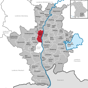
| Location of the community of Schechen in the district of Rosenheim | ||
  |
||


Schechen is a municipality in the Upper Bavarian district of Rosenheim . Since the regional reform in 1978, the until then independent communities Hochstätt, Marienberg and the northern part of the former community Westerndorf St. Peter (Pfaffenhofen a. Inn) belong to it.
Community structure
The municipality of Schechen has 36 districts:
|
|
history
Until the church is planted
Schechen was first mentioned in 1311 as a Schehen in a sales contract between the Augustinian Canons - Reichersberg Abbey and the Benedictine monastery Ebersberg . Schechen was part of the Munich Rent Office . In Schechen there was an open Hofmark , which the Tannel family took over by marriage in 1419 and held it until 1628. The congregation of the English Misses in Altötting owned them until the secularization of 1803.
With the opening of the Rosenheim – Mühldorf railway line , Schechen was connected to the railway network on May 1, 1876.
The municipality of Schechen was created by the municipal edict of 1818 .
Incorporations
On May 1, 1978 the previously independent communities of Hochstätt and Marienberg and the northern part of the dissolved community of Westerndorf-St. Peter (with the parish village Pfaffenhofen am Inn) incorporated.
Population development
Between 1988 and 2018, the community grew from 3,551 to 4,990 by 1,439 inhabitants or 40.5%.
Architectural monuments
Individual evidence
- ↑ "Data 2" sheet, Statistical Report A1200C 202041 Population of the municipalities, districts and administrative districts 1st quarter 2020 (population based on the 2011 census) ( help ).
- ↑ Entry in the location database
- ^ Federal Statistical Office (ed.): Historical municipality directory for the Federal Republic of Germany. Name, border and key number changes in municipalities, counties and administrative districts from May 27, 1970 to December 31, 1982 . W. Kohlhammer GmbH, Stuttgart / Mainz 1983, ISBN 3-17-003263-1 , p. 588 .
Web links
- Entry on the Schechen coat of arms in the database of the House of Bavarian History

Albaching | Amerang | Aschau im Chiemgau | Babensham | Bad Aibling | Bad Endorf | Bad Feilnbach | Bernau am Chiemsee | Brannenburg | Breitbrunn am Chiemsee | Bruckmühl | Chiemsee | Edling | Eggstätt | Eiselfing | Feldkirchen-Westerham | Flintsbach am Inn | Frasdorf | Griesstätt | Großkarolinenfeld | Gstadt am Chiemsee | Halfing | Höslwang | Kiefersfelden | Kolbermoor | New building | Nussdorf am Inn | Oberaudorf | Pfaffing | Prien am Chiemsee | Prutting | Ramerberg | Raubling | Riedering | Rimsting | Rohrdorf | Rott am Inn | Samerberg | Schechen | Schonstett | Söchtenau | Soyen | Stephanskirchen | Tuntenhausen | Vogtareuth | Wasserburg am Inn
Unregulated areas in the district of Rosenheim
Rotter Forst-Nord |
Rotter Forst-Süd