Rott am Inn
| coat of arms | Germany map | |
|---|---|---|

|
Coordinates: 47 ° 59 ' N , 12 ° 8' E |
|
| Basic data | ||
| State : | Bavaria | |
| Administrative region : | Upper Bavaria | |
| County : | Rosenheim | |
| Management Community : | Rott am Inn | |
| Height : | 481 m above sea level NHN | |
| Area : | 19.57 km 2 | |
| Residents: | 4098 (Dec. 31, 2019) | |
| Population density : | 209 inhabitants per km 2 | |
| Postal code : | 83543 | |
| Area code : | 08039 | |
| License plate : | RO , AIB , WS | |
| Community key : | 09 1 87 170 | |
| Community structure: | 32 districts | |
| Address of the municipal administration: |
Kaiserhof 3 83543 Rott a.Inn |
|
| Website : | ||
| Mayor : | Daniel Wendrock (independent) | |
| Location of the municipality of Rott a.Inn in the district of Rosenheim | ||
Rott am Inn (officially Rott a.Inn ) is a municipality in the Upper Bavarian district of Rosenheim and the seat of the administrative community Rott am Inn .
geography
Rott am Inn is located in the Rosenheim district in Upper Bavaria , halfway between Rosenheim and Wasserburg am Inn on the edge of the Inn ditch .
Community structure
Rott am Inn has 32 districts:
|
Neighboring communities
| Pfaffing | Ramerberg | |
| Emmering |

|
Griesstätt |
|
Rotter Forst-Nord (municipality-free area) |
Schechen |
climate
The climate of the southern Bavarian Alpine foothills is characterized by a noticeable continental impact. In addition to more abundant precipitation in summer, this also means a numerically lower occurrence of a weather change, greater frequency of high pressure situations with an easterly air supply, the latter especially in the winter half-year. However, around 60% of the sunshine duration in summer is reached on days with heavy thunderstorms, which then usually form the end of a previously beautiful day.
history
Until the 19th century
Rott am Inn is named after the river Rott, which flows into the Inn east of Feldkirchen . The document form "ad Rota" (769) and "flumen qui dictur Rota" (773), as well as the dialect form Roud refer to "Rotaha", which means "red brook". The founding of the monastery is mentioned in a document in 1081 . Abbot Benedict II (1757–1776) had a new monastery church built in place of the Romanesque basilica. For centuries, the Benedictine Abbey of Rott am Inn was one of the spiritual centers of Old Bavaria . After the secularization , the place lost its importance.
With the opening of the Rosenheim – Mühldorf railway , Rott am Inn was connected to the railway network on May 1, 1876 .
Administrative community
Today Rott am Inn is the seat of an administrative association to which the municipality of Ramerberg belongs. The economic basis of the community is agriculture and a number of well-established businesses.
Incorporations
On January 1, 1882, the previously independent community of Feldkirchen was incorporated.
Population development
Between 1988 and 2018 the community grew from 3,006 to 4,067 by 1,061 inhabitants or 35.3%.
religion
77% of the residents are Catholic, 7% Protestant. The Catholics belong to the parish of St. Peter and Paul in the Archdiocese of Munich and Freising with the parish church of St. Marinus and Anianus and the branch church of Our Lady (Feldkirchen) . The Lutherans are assigned to the parish Wasserburg am Inn of the Evangelical Lutheran Church in Bavaria .
coat of arms
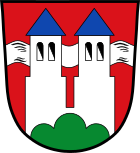
The two towers as the main figure of the coat of arms correspond to a seal of the former Benedictine abbey that was first documented in 1358 . The green Dreiberg in Schildfuß indicates the elevated position of the village and the monastery above the Inn valley . The silver band under the towers symbolizes the river Inn.
Architectural monuments
Personalities
Sons and daughters of the church
- Kuno II von Rott († 1081), co-founder of the Rott Monastery
- Hans Georg Asam (1649–1711), German baroque church painter
- Max Zwicknagl (1900–1969), German entrepreneur and politician (BVP, CSU)
- Albert Baumgartner (1919–2008), German meteorologist
- Marianne Strauss (1930–1984), wife of Franz Josef Strauss
- Christoph Betzl (* 1949), German motorcycle track racer
- Hans Hs Winkler (* 1955), German artist
- Rudolf Amann (* 1961), German microbiologist
Honorary citizen
- Franz Josef Strauss (1915–1988), former Bavarian Prime Minister, buried in Rott am Inn
- Gottfried Hain, patron of the community
Individual evidence
- ↑ "Data 2" sheet, Statistical Report A1200C 202041 Population of the municipalities, districts and administrative districts 1st quarter 2020 (population based on the 2011 census) ( help ).
- ↑ Renate Drax: Daniel Wendrock takes over in Rott! March 15, 2020, accessed May 1, 2020 .
- ↑ Rott a.Inn. In: Bayerische Landesbibliothek Online. Retrieved February 20, 2018 .
- ^ Wilhelm Volkert (ed.): Handbook of Bavarian offices, communities and courts 1799–1980 . CH Beck, Munich 1983, ISBN 3-406-09669-7 , p. 589 .
- ↑ 2011 census
Web links
- Entry on the coat of arms of Rott am Inn in the database of the House of Bavarian History


