
Emmering (Ebersberg district)
| coat of arms | Germany map | |
|---|---|---|

|
Coordinates: 48 ° 0 ' N , 12 ° 3' E |
|
| Basic data | ||
| State : | Bavaria | |
| Administrative region : | Upper Bavaria | |
| County : | Ebersberg | |
| Management Community : | Aßling | |
| Height : | 515 m above sea level NHN | |
| Area : | 17.22 km 2 | |
| Residents: | 1508 (Dec. 31, 2019) | |
| Population density : | 88 inhabitants per km 2 | |
| Postal code : | 83550 | |
| Area code : | 08039 | |
| License plate : | EBE | |
| Community key : | 09 1 75 136 | |
| Address of the municipal administration: |
Bahnhofstrasse 1 85617 Aßling |
|
| Mayoress : | Claudia Streu-Schütze ( FWG Emmering ) | |
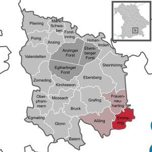
| Location of the municipality of Emmering in the district of Ebersberg | ||
  |
||

Emmering is a municipality in the Upper Bavarian district of Ebersberg and a member of the Aßling administrative community .
geography

The community is located in the Munich region about 14 km southeast of the district town of Ebersberg , 20 km southwest of Wasserburg and 21 km northwest of Rosenheim . The closest station on the Munich-Salzburg railway line is in Aßling, five kilometers away .
There is only the district Emmering.
history
Until the church is planted
Emmering belonged to the Munich Rent Office and to the Swabian Regional Court of the Electorate of Bavaria . In the course of the administrative reforms in Bavaria , the community of Schalldorf came into being with the community edict of 1818 .
There is a short summary of the story on the website of the Aßling administrative association.
20th century
After the Second World War , up to 200 refugees were accommodated in the attic of the "Bichler" inn in Emmering. Then they came to the "Wagenreith" camp, about one kilometer south of Emmering. Then they were distributed to farms in the area.
Reclassification and name change
On May 1, 1978, part of the dissolved community of Lampferding was reclassified to Schalldorf. On May 2, 1978, just one day later, the name of the community Schalldorf was officially changed to Emmering .
Population development
Between 1988 and 2018 the municipality grew from 1,202 to 1,504 by 302 inhabitants or by 25.1%.
|
|
coat of arms
The description of the coat of arms reads: In silver, a lowered red rafter, above it two slanted red stag poles.
Architectural monuments
Soil monuments
Economy and Infrastructure
Economy including agriculture and forestry
According to official statistics, there were a total of 617 employees subject to social security contributions in 2018. Of these, 42 people worked in the manufacturing sector, 19 in trade, transport, hospitality and 64 in other branches of the economy. In the manufacturing sector there were no companies with 20 or more employees, in the construction industry 7. In addition, in 2016 there were 50 agricultural companies with an agricultural area of 1331 ha, of which 837 ha were permanent green space.
education
In 2020 the following institutions exist:
- Kindergartens: 50 kindergarten places with 50 children
- Schools: Second location of the Aßling elementary and middle school
Sons and daughters of the church
- Josef Vogl (1848–1886), founded the first Bavarian costume association in Bayrischzell in 1883
- Benedikt Mayer (* 1953), from 2011 to 2018 Federal Treasurer of the Bündnis 90 / Die Grünen party
Web links
- Emmering (Ebersberg district): Official statistics of the LfStat
- Hirschbichl Castle in Emmering on sueddeutsche.de, accessed on June 13, 2015
Individual evidence
- ↑ "Data 2" sheet, Statistical Report A1200C 202041 Population of the municipalities, districts and administrative districts 1st quarter 2020 (population based on the 2011 census) ( help ).
- ↑ https://www.vg-assling.de/index.php?sa=7&sn=505994&si=505995
- ↑ History (PDF; 9 kB)
- ^ Federal Statistical Office (ed.): Historical municipality directory for the Federal Republic of Germany. Name, border and key number changes in municipalities, counties and administrative districts from May 27, 1970 to December 31, 1982 . W. Kohlhammer GmbH, Stuttgart / Mainz 1983, ISBN 3-17-003263-1 , p. 572 .
- ↑ Entry on the coat of arms of Emmering (Ebersberg district) in the database of the House of Bavarian History

Anzing | Aßling | Bavaria | Bruck | Ebersberg | Egmating | Emmering | Forstinning | Frauenneuharting | Glonn | Grafing near Munich | Hohenlinden | Kirchseeon | Market Swabia | Moosach | Oberpframmer | Pliening | Poing | Steinhöring | Vaterstetten | Anger thing
Unregulated areas: Anzinger Forst | Ebersberger Forest | Eglhartinger Forest