
Frauenneuharting
| coat of arms | Germany map | |
|---|---|---|

|
Coordinates: 48 ° 2 ' N , 12 ° 3' E |
|
| Basic data | ||
| State : | Bavaria | |
| Administrative region : | Upper Bavaria | |
| County : | Ebersberg | |
| Management Community : | Aßling | |
| Height : | 530 m above sea level NHN | |
| Area : | 22.69 km 2 | |
| Residents: | 1577 (Dec. 31, 2019) | |
| Population density : | 70 inhabitants per km 2 | |
| Postal code : | 83553 | |
| Area code : | 08092 | |
| License plate : | EBE | |
| Community key : | 09 1 75 119 | |
| LOCODE : | DE ZFG | |
| Association administration address: | Bahnhofstrasse 1 85617 Aßling |
|
| Website : | ||
| Mayor : | Eduard Koch (Voting Association Frauenneuharting) | |
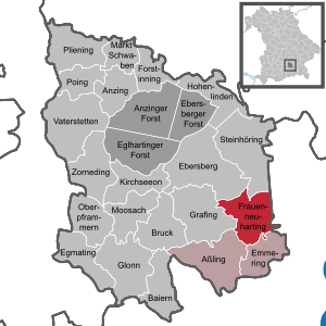
| Location of the community of Frauenneuharting in the district of Ebersberg | ||
  |
||

Frauenneuharting is a municipality in the Upper Bavarian district of Ebersberg .
geography
location
Frauenneuharting is located in the Munich region in the foothills of the Alps, around seven kilometers east of Grafing , 19 km southwest of Wasserburg , 28 km north of Rosenheim and eleven kilometers from the district town of Ebersberg .
Community structure
Districts of the community Frauenneuharting are: The parish village Frauenneuharting; the Kirchdörfer Haging , Jakobneuharting , Lauterbach and Tegernau ; the villages of Eschenlohe and Gersdorf ; the hamlets of Aichat , Baumberg , Buch , Eichbichl , Graben , Haus , Heimgarten , Lochen , Moosen and Wimpersing and the deserted Alme , Anger , Biebing , Geisfeld , Großaschau , Hagenberg , Halbeis , Hinteraschau , Hochholz , Höhenberg , Hungerberg , Kleinaschau , Knogl , Lacke , Lettenberg , Lindach , Mayer am Haus , Oed , Raunstädt , Reith , Ried , Schaurach , Spezigraben , Stachet and Zell .
history
Until the church is planted
The church in Frauenneuharting was consecrated around the year 1000. The Catholic parish church of the Visitation of the Virgin Mary in Frauenneuharting is essentially late Gothic , the baroque expansion took place in 1632. Frauenneuharting belonged to the Munich Rent Office and to the Swabian Regional Court of the Electorate of Bavaria and was the seat of a main team. From 1381 to 1800 , the lords of Pienzenau were associated with Jakobneuharting, the former Neuharting, and the surrounding villages as court lords . In the course of the administrative reforms in Bavaria , today's municipality was created with the municipal edict of 1818 .
20th and 21st centuries
On December 29, 1944, a USAAF bombing raid hit a refugee barracks. Five members of an evacuated Munich family were killed. The attack was probably aimed at a measuring station of the " Office for Wave Propagation " in Munich - a research institute of the Reichspost , which was set up in 1942 at Jakobneuharting. The system itself was not hit. The purpose of the facility was to research the propagation of bumps and the facility was named "Grafing Station".
Population development
Between 1988 and 2018 the municipality grew from 1,150 to 1,571 by 421 inhabitants or 36.6%.
- 1970: 1079 inhabitants
- 1987: 1115 inhabitants
- 1991: 1221 inhabitants
- 1995: 1284 inhabitants
- 2000: 1314 inhabitants
- 2005: 1438 inhabitants
- 2010: 1475 inhabitants
- 2015: 1517 inhabitants
politics
The community is a member of the Aßling administrative community .
mayor
The first mayor is Eduard Koch (Frauenneuharting Voting Association). He has been in office since May 1, 2014 and is the successor to Josef Singer (List 2).
coat of arms
The coat of arms shows a black sloping bar covered with three gold spheres in silver; above a five-pointed blue star, underneath a red shell .
Architectural monuments
Economy and Infrastructure
Economy including agriculture and forestry
In 1998, according to official statistics, there were no employees at the place of work in the manufacturing sector 131 or in the trade and transport sector. In other economic sectors, twelve people were employed at the place of work subject to social security contributions. There were a total of 409 employees at the place of residence subject to social insurance contributions. There was one company in the manufacturing sector and four companies in the construction sector. In 1999 there were also 89 farms with an agriculturally used area of 1788 ha, of which 531 ha were arable land and 1253 ha were permanent green space.
traffic
Frauenneuharting is on the district road EBE 20, via the u. a. Steinhöring and Aßling can be reached. It is around 23 km to the A 94 (Forstinning junction) and 29 km to the A 99 (Haar junction). The federal highway 304 , which runs from Munich to Freilassing on the border with Austria, is about five kilometers from Tulling .
The nearest train stations are Tulling and Steinhöring on the Grafing – Wasserburg railway (five and seven kilometers away, respectively), Grafing Stadt with a connection to the S-Bahn and Aßling on the Munich – Rosenheim railway (both seven kilometers away).

The MVV regional bus line 444 connects Frauenneuharting and the districts of Aichat, Gersdorf, Haging, Haus, Hungerberg, Jakobneuharting and Tegernau with each other and with the train stations Aßling , Grafing Stadt and Grafing Bahnhof . In addition, the MVV on-call bus route 443, which has been in service since December 15, 2014, provides bus connections between Frauenneuharting and the Tulling and Steinhöring stations , where you can change to the Grafing – Wasserburg railway line . In addition, the districts of Baumberg and Lauterbach will be connected to local public transport for the first time by the MVV on-call bus route 443.
education
In 1999 the following institutions existed:
- Kindergartens: 50 kindergarten places with 51 children
- Elementary schools: one with ten teachers and 165 students
Web links
Individual evidence
- ↑ "Data 2" sheet, Statistical Report A1200C 202041 Population of the municipalities, districts and administrative districts 1st quarter 2020 (population based on the 2011 census) ( help ).
- ↑ a b Mayor / Lord Mayor in municipalities belonging to the district (as of May 1st, 2020). (xlsx) Bavarian State Office for Statistics, accessed on June 20, 2020 .
- ^ Community Frauenneuharting in the local database of the Bavarian State Library Online . Bayerische Staatsbibliothek, accessed on September 6, 2018.
- ^ [1] CIOS XXXI-I "Establishments of the Research Institute of the Deutsche Reichspost", Combined Intelligence Objectives Sub-committee
- ↑ PDF "On the history of geophysics", 2008
- ^ Entry on the coat of arms of Frauenneuharting in the database of the House of Bavarian History
- ↑ Omnibus Reisberger: MVV regular service
- ↑ Ebersberger district administrator has to get up earlier. In: merkur-online.de. January 8, 2015, accessed January 14, 2015 .

Anzing | Aßling | Bavaria | Bruck | Ebersberg | Egmating | Emmering | Forstinning | Frauenneuharting | Glonn | Grafing near Munich | Hohenlinden | Kirchseeon | Market Swabia | Moosach | Oberpframmer | Pliening | Poing | Steinhöring | Vaterstetten | Anger thing
Unregulated areas: Anzinger Forst | Ebersberger Forest | Eglhartinger Forest