
Hohenlinden
| coat of arms | Germany map | |
|---|---|---|

|
Coordinates: 48 ° 9 ' N , 12 ° 0' E |
|
| Basic data | ||
| State : | Bavaria | |
| Administrative region : | Upper Bavaria | |
| County : | Ebersberg | |
| Height : | 540 m above sea level NHN | |
| Area : | 17.32 km 2 | |
| Residents: | 3214 (Dec. 31, 2019) | |
| Population density : | 186 inhabitants per km 2 | |
| Postal code : | 85664 | |
| Area code : | 08124 | |
| License plate : | EBE | |
| Community key : | 09 1 75 123 | |
| Address of the municipal administration: |
Rathausplatz 1 85664 Hohenlinden |
|
| Website : | ||
| Mayor : | Ludwig Maurer (overpart. Voters) | |
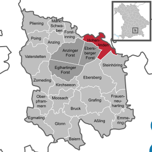
| Location of the community Hohenlinden in the district of Ebersberg | ||
  |
||

Hohenlinden is a municipality in the Upper Bavarian district of Ebersberg . The place of the same name is the main town and seat of the municipal administration.
geography
location
The municipality is located in the Munich region . The main town is about 10 km north of Ebersberg , 18 km south of Erding and 34 km east of the state capital Munich .
Structure of the municipal area
There are 15 parish parts:
|
The districts are Ebersberger Forst and Hohenlinden.
history
Hofmark
The place was part of the Electorate of Bavaria and belonged to the closed Hofmark Ebersberg of the Order of St. John , which was dissolved in 1808.
The Battle of Hohenlinden took place here on December 3, 1800 .
coat of arms
|
|
Blazon : "In silver on a blue mountain, with two silver swords crossed diagonally, a green linden tree." |
Religions
In Hohenlinden there is the Church of the Visitation of the Virgin Mary , built in 1489 in late Gothic style, and the parish church of St. Josef , built in 1903 by Hans Schurr in neo-Gothic style .
Population development
Between 1988 and 2018 the municipality grew from 2,176 to 3,228 by 1,052 inhabitants or 48.4%.
| year | Residents |
|---|---|
| 1970 | 1854 |
| 1987 | 2149 |
| 1991 | 2254 |
| 1995 | 2463 |
| 2000 | 2616 |
| 2005 | 2758 |
| 2010 | 2822 |
| 2015 | 3057 |

Architectural monuments
tourism
The small tourist resort has various leisure activities from hiking to golf on the nearby Gut Thailing or the GC Ebersberg to the Waldlehrsteig, the so-called Hohenlindener Sauschütt in the nearby Ebersberger Forest , which is ideal for hiking and cycling .

Economy and Infrastructure
Economy including agriculture and forestry
In 1998, according to official statistics, there were no employees at the place of work in the manufacturing sector or in the trade and transport sector. In other economic sectors this value was 1470 people. There were 1103 employees subject to social security contributions at the place of residence. There were none in the manufacturing sector and five in the construction sector. In 1999 there were also 43 farms with an agricultural area of 772 hectares.
Lentner , a company that manufactures fire fighting vehicles , is based in Hohenlinden.
traffic
Hohenlinden is located at the intersection of the two state roads 2086 and 2331 and the B 12 , which serves as a bypass . In addition, the municipality received its own junction via the A 94 motorway, which opened on August 31, 2011 and runs north-west of the site (12).
To monitor the southern airspace, there is a DFS tower with an SRE-M radar system in the Großhaager Forest southeast of Hohenlinden . Each of these six systems nationwide has a detection radius of around 145 NM ( nautical miles , corresponds to 270 km).
education
In 2012 existed
- two kindergartens for up to 100 children (from two years)
- a primary school with four grades
Web links
Individual evidence
- ↑ "Data 2" sheet, Statistical Report A1200C 202041 Population of the municipalities, districts and administrative districts 1st quarter 2020 (population based on the 2011 census) ( help ).
- ↑ Mayor. Hohenlinden community, accessed on August 21, 2020 .
- ^ Community Hohenlinden in the local database of the Bavarian State Library Online . Bavarian State Library, accessed on December 27, 2017.
- ^ Local history of Hohenlinden. Hohenlinden community, accessed on August 21, 2020 .
- ↑ Entry on the Hohenlinden coat of arms in the database of the House of Bavarian History

Anzing | Aßling | Bavaria | Bruck | Ebersberg | Egmating | Emmering | Forstinning | Frauenneuharting | Glonn | Grafing near Munich | Hohenlinden | Kirchseeon | Market Swabia | Moosach | Oberpframmer | Pliening | Poing | Steinhöring | Vaterstetten | Anger thing
Unregulated areas: Anzinger Forst | Ebersberger Forest | Eglhartinger Forest
Hohenlinden | Altmuehlhausen | Altstockach | Au | Mountain | Birkach | Karlsdorf | Kreith | Kronacker | Neumühlhausen | Neupullach | Neustockach | Niederkaging | Oberkaging | Sauschütt