
Flintsbach am Inn
| coat of arms | Germany map | |
|---|---|---|

|
Coordinates: 47 ° 43 ' N , 12 ° 8' E |
|
| Basic data | ||
| State : | Bavaria | |
| Administrative region : | Upper Bavaria | |
| County : | Rosenheim | |
| Height : | 479 m above sea level NHN | |
| Area : | 31.3 km 2 | |
| Residents: | 3025 (Dec. 31, 2019) | |
| Population density : | 97 inhabitants per km 2 | |
| Postal code : | 83126 | |
| Area code : | 08034 | |
| License plate : | RO , AIB , WS | |
| Community key : | 09 1 87 131 | |
| Community structure: | 17 districts | |
| Address of the municipal administration: |
Kirchstrasse 9 83126 Flintsbach a.Inn |
|
| Website : | ||
| Mayor : | Stefan Lederwascher ( CSU ) | |
| Location of the municipality of Flintsbach a.Inn in the district of Rosenheim | ||
  |
||

Flintsbach am Inn (officially: Flintsbach a.Inn ) is a municipality in the Upper Bavarian district of Rosenheim .
geography
Geographical location and traffic
Flintsbach am Inn borders directly to the south on the larger neighboring municipality of Brannenburg . Flintsbach lies at the foot of the Großer Madron, Petersberg, Maiwand and Riesenkopf. The state road 2089 and the federal highway 93 run through the community. Flintsbach is on the junction Brannenburg directly accessible. After Rosenheim is 17 km, to Oberaudorf 10 km over the Sudelfeld according Bayrischzell (20 km toll road). The state capital Munich is approx. 70 km away, to Kufstein in the neighboring Tyrol it is 17 km and to Salzburg 70 km. In Flintsbach there is a train station on the Rosenheim – Kufstein line , which is only served by the Meridian every hour. There are regular bus connections in the direction of Rosenheim and Kufstein as well as with the "Wendelstein ring line" in the direction of Bad Feilnbach , Fischbachau and Bayrischzell. At the weekend the discobus runs between the cities of Kufstein and Rosenheim for night owls . Particularly popular with motorcyclists is the winding and toll road Sudelfeldstraße , which leads past the Tatzelwurm waterfall to Bayrischzell (German Alpine Road). The highest point in the municipality is the summit of the little-known Dümpfel (Dümpfl) at 1354 meters . Just behind it are the Riesenkopf at 1337 meters and the Rehleitenkopf at 1338 meters.
Neighboring communities
| Brannenburg | ||
.svg)
|
Nussdorf am Inn | |
| Oberaudorf |
Erl (Tyrol) |
Community structure
There are 17 parish parts:
|
history
Until the 19th century
Flintsbach am Inn (formerly: Flinsbach ) was first mentioned in a document in 986. Among other things, the oldest Sigboton possessions were located here . Before 1800 Flintsbach was part of the Falkenstein rule of the Counts of Preysing . In the course of the administrative reforms in Bavaria in 1818, the place became an independent political municipality. Flintsbach was mentioned for the first time in the traditional codices of the Brixen Cathedral monastery in the years 975 - 1006. Around 1165 it also appeared in the famous Falkensteiner Codex of Count Siboto IV of Falkenstein and was the chief town of these counts, who were one of the most important families of Southeast Bavaria and the four Owned territories of Neuburg near Vagen (Bad Aibling), Falkenstein in the Inntal, Hartmannsberg west of the Chiemsee and Hernstein in the Vienna Woods.
Coat of arms history:
The falcon is the heraldic symbol that speaks for the name of the Count of Falkenstein, who died out around 1272. The dynasty was wealthy in Flintsbach and the surrounding area and exercised court and manorial rule. Falkenstein Castle was located in the district of Flintsbach. To distinguish it from other municipal coats of arms with the golden Falkensteiner falcon (Feldkirchen-Westerham, Oberaudorf, Prien etc.) the falcon was given a different color with silver and was depicted sitting on a pinnacle tower. The tin tower symbolizes the still-preserved tower ruins of Falkenstein Castle. In order to maintain this historical connection, a part of the community was given the name Falkenstein.
Flintsbach was also the original parish whose borders included Oberaudorf and Kiefersfelden in the south until 1868 and Degerndorf in the north until 1952. The courtyards of that time, whose house names have been preserved to this day, belonged to Falkenstein Castle, the Petersberg Provost or the Flintsbach parish church.
20th century
111 members of the parish died in the Second World War, 54 are missing and 4 perished in their homeland.
In 1970 Flintsbach was elevated to a climatic health resort.
Incorporations
On April 1, 1971, parts of the area of the dissolved community of Niederaudorf were incorporated.
Population development
Between 1988 and 2018 the municipality grew from 2,207 to 3,033 by 826 inhabitants or 37.4%.
politics
Municipal council
14 voluntary councilors together with the full-time mayor make up the council of Flintsbach am Inn. The election on March 16, 2014 resulted in the following:
| 2014 | 2008 | 2002 | |
|---|---|---|---|
| Total seats | 14th | 14th | 14th |
| CSU | 7th | 6th | 7th |
| SPD | 3 | 3 | 4th |
| FW Flintsbach-Fischbach | 4th | 5 | 3 |
mayor
In the 2014 local elections , Mayor Wolfgang Berthaler (CSU) , who has been in office since 1996, was elected as District Administrator of the Rosenheim district. Stefan Lederwascher (CSU) was elected as the new mayor.
climate
The prevailing microclimate in Flintsbach can be explained by its location at a narrow point in the Inn Valley, as well as the altitude of 479 meters above sea level. Another important influence is the so-called 'Erler Wind', a strong orographic fall wind that sets in late in the evening and mostly flows back in the opposite direction in the late morning around 11 a.m., i.e. towards the valley, although less strongly. In the past, the Erler wind was considered a safe barometer, since if it did not flow back, it was very likely that the beautiful weather would end.
The continental influence that dominates the southern part of Germany is also noticeable in Flintsbach, where cold winters with average temperatures between −6 and +2 ° C prevail during the day due to the spatial proximity to the Alps. About half of the precipitation falls in the form of snow, so that the ground is usually covered by a blanket of snow (between 15 and 30 cm) in winter.
In summer, the temperatures are similar to those in the rest of Germany, averaging between 13 ° C in the morning and 23 ° C in the afternoon. But summer is also the wettest time of the year. Mighty thunderclouds, which are driven against the mountain slopes, unload with not infrequently heavy downpours. In the months of June and July, precipitation values of up to 150 mm per month are often reached, the annual average is around 1075 mm. Despite these numerous thunderstorms, which usually occur in the late afternoon, the sun shines an average of 8 hours a day.
Culture and sights
- See also the list of architectural monuments in Flintsbach am Inn
- Volkstheater (the second oldest popular theater in Germany)
- Parish Church of St. Martin
- St. Peter am Madron Monastery (pilgrimage church on the Petersberg )
- Glacier cut east of Fischbach
- Castle ruins Ober-Falkenstein , Unter-Falkenstein and Kirnstein
- Petersberg with the excavation site of an old monastery cemetery
- Parish museum with important finds from Roman times
- Wolfsgrube (sinkhole)
- Philosopher's Fall and Wolfsschlucht (30 and 40 meter high waterfalls)
- Vogelinsel in the Inn
- Hohe Asten (highest farms in Germany)
- Arzmoos ( Hochalm area and waterfall at Sudelfeld )
Tourism continues to play a major role in the community, with numerous private landlords and inns offering guest rooms and holiday apartments. In the post-war years, tourism was the main source of income for the local population.

Flintsbach before Petersberg (left), Rehleitenkopf, Maiwand, Großer Riesenkopf (right)

Flintsbach from Petersberg seen from

Parish Church of St. Martin

Parish Church of St. Martin, interior
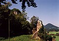
Unter-Falkenstein castle ruins


music
The Musikkapelle Flintsbach eV was founded in 1907 from members of the Choir Music Society. Based on research in the archives of the parish of St. Martin in Flintsbach, the time when the Choir Music Society was founded can be specified between 1800 and 1820. That is why the Flintsbach music band celebrated "200 years of Flintsbach brass music" in 2005 in conjunction with the Inn-Chiemgau district music festival. In 2016, the band was once again awarded the contract to host the district music festival.
The band currently has 55 active musicians and is one of the main cultural bearers of the community. Every year the traditional Easter concert takes place on Easter Sunday and a Christmas concert during Advent. On New Year's Eve, the New Year is played in 4 groups at each door in the community area (New Year blowing). Every two years in autumn the music band in the alpine pasture area of Arzmoos am Sudelfeld organizes a Weisenbläsertreffen, which is very popular.
Economy and Infrastructure
In Flintsbach there are a large number of craft businesses, restaurants and retail outlets. The REWE Group operates a penny market. The largest employer in the community is the Dettendorfer forwarding company.
sport and freetime
- Sport climbing area with a wide range of tours (demanding climbing tours up to the IX level of difficulty)
- Riesenbergloipe (extensive network of cross-country trails)
- Bathing possibilities: Lido with over 10,000 m² of water and various facilities (mini golf, beach volleyball, playground and restaurants), Lake Hawaii, Camping Lake and Lake Kirnstein
Personalities
- George III von Ortenburg (1473–1553), provost on the kl. Madron
- Abraham Millauer (1683–1758), rococo church builder, builder of the parish church of St. Martin
- Sebastian Dachauer (1778–1863), theologian and local history researcher
- Otto von Steinbeis (1839–1920), German entrepreneur and industrial pioneer, buried in Flintsbach
- Ernst Nittner (1915–1997), historian
- Josef Rosenegger (1917–2010), Catholic clergyman
- Reiner Kaczynski (1939–2015), theologian and liturgical scholar
- Christian Peschke (1946–2017), sculptor and painter, buried in Flintsbach
- Werner Stocker (1955–1993), actor
- Wolfgang Berthaler (* 1956), long-time mayor and acting district administrator of the Rosenheim district
- Michael Fischer (* 1976), actor
- Daniel Hilpert (* 1981), ice hockey player
- Jakob Lange (* 1995), Nordic combined, junior world champion relay
literature
- Antom Quitzmann: Documentary history of Flinsbach, in the district of Rosenheim In: Upper Bavarian Archive for Fatherland History , Volume 32, Munich 1872–73, pp. 77–225.
Web links
Individual evidence
- ↑ "Data 2" sheet, Statistical Report A1200C 202041 Population of the municipalities, districts and administrative districts 1st quarter 2020 (population based on the 2011 census) ( help ).
- ↑ Mayor. Municipality of Flintsbach am Inn, accessed on July 4, 2020 .
- ↑ http://www.bayerische-landesbibliothek-online.de/orte/ortssuche_action.html ? Anzeige=voll&modus=automat&tempus=+20111022/193944&attr=OBJ&val= 505
- ^ Wilhelm Volkert (ed.): Handbook of Bavarian offices, communities and courts 1799–1980 . CH Beck, Munich 1983, ISBN 3-406-09669-7 , p. 561 .
- ↑ a b http://www.rosenheim24.de/rosenheim/kommunalwahlen/buergermeister-gemeinderatswahl-flintsbach-inn-kandidaten-results-3401223.html
- ↑ a b c Local elections in Bavaria

Albaching | Amerang | Aschau im Chiemgau | Babensham | Bad Aibling | Bad Endorf | Bad Feilnbach | Bernau am Chiemsee | Brannenburg | Breitbrunn am Chiemsee | Bruckmühl | Chiemsee | Edling | Eggstätt | Eiselfing | Feldkirchen-Westerham | Flintsbach am Inn | Frasdorf | Griesstätt | Großkarolinenfeld | Gstadt am Chiemsee | Halfing | Höslwang | Kiefersfelden | Kolbermoor | New building | Nussdorf am Inn | Oberaudorf | Pfaffing | Prien am Chiemsee | Prutting | Ramerberg | Raubling | Riedering | Rimsting | Rohrdorf | Rott am Inn | Samerberg | Schechen | Schonstett | Söchtenau | Soyen | Stephanskirchen | Tuntenhausen | Vogtareuth | Wasserburg am Inn
Unregulated areas in the district of Rosenheim
Rotter Forst-Nord |
Rotter Forst-Süd