
Rimsting
| coat of arms | Germany map | |
|---|---|---|

|
Coordinates: 47 ° 53 ' N , 12 ° 20' E |
|
| Basic data | ||
| State : | Bavaria | |
| Administrative region : | Upper Bavaria | |
| County : | Rosenheim | |
| Height : | 564 m above sea level NHN | |
| Area : | 20 km 2 | |
| Residents: | 3969 (Dec. 31, 2019) | |
| Population density : | 198 inhabitants per km 2 | |
| Postal code : | 83253 | |
| Area code : | 08051 | |
| License plate : | RO , AIB , WS | |
| Community key : | 09 1 87 168 | |
| LOCODE : | DE RMS | |
| Community structure: | 49 districts | |
| Address of the municipal administration: |
Schulstrasse 4 83253 Rimsting |
|
| Website : | ||
| Mayor : | Andreas Fenzl ( CSU ) | |
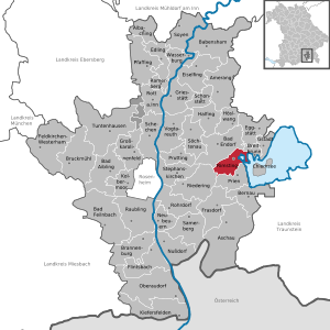
| Location of the municipality of Rimsting in the district of Rosenheim | ||
  |
||

Rimsting is a municipality in the Upper Bavarian district of Rosenheim . The climatic health resort is located on the Chiemsee between the health resorts of Prien am Chiemsee (three kilometers) and Bad Endorf (five kilometers).
Community structure
Rimsting has 49 districts:
history
Until the church is planted
The first documentary mention in Codex Falkensteinensis took place in 1189, but it was founded in the 7th century. Like Greimharting, Rimsting belonged to the Wildenwart dominion, which was endowed with high jurisdiction . Rimsting became an independent political municipality in the course of the administrative reforms in Bavaria in 1818 .
Incorporations
On April 1, 1970, the Greimharting community was voluntarily incorporated into the Rimsting community. On April 1, 1971, parts of the dissolved community of Mauerkirchen (Sieglweiher, Gmein and Hötzelsberg) were incorporated. On January 1, 1972, parts of Hirnsberg (Hocheck) were added. In 1978 the villages of Ratzing with Herrgottswinkel, Hitzing and Kindlpoint came from the municipality of Pietzing to the municipality of Rimsting.
religion
In 2003 64% of the population were Catholic and 17% Protestant. By 2011 the proportion of Catholics fell to 62% and the proportion of Protestants to 15%.
The Catholic parish of Rimsting with the parish church of St. Nikolaus belongs to the parish association "Westliches Chiemseeufer" in the Archdiocese of Munich and Freising . The church of St. Petrus and St. Leonhard in Greimharting belongs to the parish of the Assumption of Mary (Prien am Chiemsee) in the same parish association. There is also the pilgrimage church of St. Salvator in the district of the same name.
The Prien am Chiemsee parish with its Christ Church is responsible for the Lutherans in Rimsting .
politics
Parish partnership
Culture and sights
art
- Lüftlmalereien on the farms
- “Steinadler” by T. Roubaud, at the corner of Priener and Greimhartinger Strasse
- Wood carver sculptures on Römerweg and the Westernach sports field
Buildings
- Parish church Rimsting " St. Nikolaus " with high altar and pulpit of the ehm. Cathedral Abbey Church on Herrenchiemsee
- Filial church " St. Petrus and St. Leonhard " in Greimharting (Parish Prien)
- Subsidiary church " St. Salvator " (Parish Prien)
- Chapel “St. Kolomann ”in Hochstätt
- Chapel "to the Immaculate Conception of Mary" near Gattern
- "Warrior Memorial Chapel" Pinswang
- "Kalkgruber Chapel"
- former train station , now used for gastronomy purposes.
- On the Ratzinger Höhe ( 693.9 m ) there has been a 16 m high observation tower since 2011 , which was formerly part of the Rosenheim State Horticultural Show and was newly built near Hitzing.
Natural monuments
- Environmental educational hut at Schafwaschener Bay
- Ratzingerhöhe fruit and culture trail
- Blahsee near Aiterbach
Regular events
- Leonhardi ride every year on November 6th in Greimharting
Personalities
- Michael Arends (* 1939), music publisher and former politician
- Axel Bartelt (* 1956), District President of the Upper Palatinate, lives in the village
- Helmut Bieler (1940–2019), composer, last lived in Rimsting and died there
- Thomas Gambke (* 1949), politician (Greens), Member of the Bundestag, born in Rimsting
- Philipp Franz zu Guttenberg (* 1973), President of the Working Group of German Forest Owners' Associations (AGDW).
- Michael Höck (1903–1996), clergyman and Nazi opponent
- Gabriele Kuby (* 1944), writer
- Hermann Mattern (1902–1971), garden designer, architect
- Caspar von Zumbusch (1830–1915), sculptor, retired to Chiemgau in 1908 and died in Rimsting.
In 2007, the economist Rudolf Meimberg transferred 50,000 euros from his assets to the community to set up a “Rudolf Meimberg Foundation” to support senior citizens and cases of social hardship.
Individual evidence
- ↑ "Data 2" sheet, Statistical Report A1200C 202041 Population of the municipalities, districts and administrative districts 1st quarter 2020 (population based on the 2011 census) ( help ).
- ↑ http://www.bayerische-landesbibliothek-online.de/orte/ortssuche_action.html ? Anzeige=voll&modus=automat&tempus=+20111022/221043&attr=OBJ&val= 524
- ^ Wilhelm Volkert (ed.): Handbook of Bavarian offices, communities and courts 1799–1980 . CH Beck, Munich 1983, ISBN 3-406-09669-7 , p. 561 .
- ^ Federal Statistical Office (ed.): Historical municipality directory for the Federal Republic of Germany. Name, border and key number changes in municipalities, counties and administrative districts from May 27, 1970 to December 31, 1982 . W. Kohlhammer GmbH, Stuttgart / Mainz 1983, ISBN 3-17-003263-1 , p. 589 .
- ↑ Sukoro. Rimsting municipality, accessed on May 9, 2020 .
- ↑ Map services of the Federal Agency for Nature Conservation ( information )
- ↑ Ratzinger Höhe observation tower on chiemsee-alpenland.de
- ^ Rudolf Meimberg Foundation on the Rimsting community website
Web links
- Entry on Rimsting's coat of arms in the database of the House of Bavarian History

Albaching | Amerang | Aschau im Chiemgau | Babensham | Bad Aibling | Bad Endorf | Bad Feilnbach | Bernau am Chiemsee | Brannenburg | Breitbrunn am Chiemsee | Bruckmühl | Chiemsee | Edling | Eggstätt | Eiselfing | Feldkirchen-Westerham | Flintsbach am Inn | Frasdorf | Griesstätt | Großkarolinenfeld | Gstadt am Chiemsee | Halfing | Höslwang | Kiefersfelden | Kolbermoor | New building | Nussdorf am Inn | Oberaudorf | Pfaffing | Prien am Chiemsee | Prutting | Ramerberg | Raubling | Riedering | Rimsting | Rohrdorf | Rott am Inn | Samerberg | Schechen | Schonstett | Söchtenau | Soyen | Stephanskirchen | Tuntenhausen | Vogtareuth | Wasserburg am Inn
Unregulated areas in the district of Rosenheim
Rotter Forst-Nord |
Rotter Forst-Süd