
Brannenburg
| coat of arms | Germany map | |
|---|---|---|

|
Coordinates: 47 ° 44 ' N , 12 ° 6' E |
|
| Basic data | ||
| State : | Bavaria | |
| Administrative region : | Upper Bavaria | |
| County : | Rosenheim | |
| Height : | 509 m above sea level NHN | |
| Area : | 33.69 km 2 | |
| Residents: | 6473 (Dec. 31, 2019) | |
| Population density : | 192 inhabitants per km 2 | |
| Postal code : | 83098 | |
| Area code : | 08034 | |
| License plate : | RO , AIB , WS | |
| Community key : | 09 1 87 120 | |
| LOCODE : | DE B6R | |
| Community structure: | 39 districts | |
| Address of the municipal administration: |
Schulweg 2 83098 Brannenburg |
|
| Website : | ||
| First Mayor : | Matthias Jokisch (CSU) | |
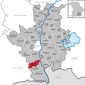
| Location of the municipality of Brannenburg in the district of Rosenheim | ||
  |
||

Brannenburg is a municipality in the Upper Bavarian district of Rosenheim .
geography
Geographical location
The community is located on the northern edge of the Alps in the Inn Valley at 509 m above sea level. NN , a few kilometers north of the border between Germany and Austria at the foot of the Hochsalwand and the Riesenkopf . The Wendelsteinbahn runs from Brannenburg to the Wendelstein , one of the most famous mountains in Bavaria . Also known and especially popular with motorcyclists is the toll road Tatzelwurm / Sudelfeldstrasse, which leads past the Tatzelwurm waterfall to Bayrischzell ( German Alpine Road ).
The village is located around 15 km south of Rosenheim , 88 km west of Salzburg , 22 km north of Kufstein , 28 km east of Miesbach and 70 km from Munich .
Nearby ski areas are the Wendelstein (Brannenburg / Bayrischzell ), the Sudelfeld (Bayrischzell / Oberaudorf) and the Hocheck ( Oberaudorf ).
topography
The district Degerndorf dominates the beaver , a nearly 25 m high, about 850 m long and a maximum of about 400 m wide, is towards the north tapered Nagelfluh massif formed during the last ice, the so-called Würm deposited in the river gravel, gravel and sand , pressed and washed out and cemented by calcareous groundwater. The elevation, which is densely forested with beech and pine trees, is only about 65% of its original size due to the fact that the Nagelfluh has been mined since the beginning of the 10th century. Initially, grinding stones and millstones were broken, in the past centuries the Nagelfluh was a coveted building block in the area: Relatively light, frost-proof and pressure-resistant, it forms, for example, the foundation of the Munich Frauenkirche or the base of the oldest high-rise in Munich, the old technical town hall . Numerous farmhouses and houses from Nagelfluh were built in the Inn Valley. In view of the uniqueness of the largest natural monument in Bavaria, including the quarries, about 0.24 km² in area, only limited quarry work is possible today; The three quarries Huber , Feicht and Grad still exist . Since the Nagelfluh has also been mined deep in the past decades, almost 50 m high steep walls rise in the area of the quarries.
The early Baroque pilgrimage church of St. Maria Magdalena is located on the Biber . It was built from 1626 during the Thirty Years' War by the resident hermit Johannes Schelle (the name Hanns Schell is also passed down). In 1664 it was given the appearance that it largely still has today. The church building is not oriented to the east, as usual, but to the southwest. The associated Way of the Cross was built between 1733 and 1736 and has been preserved in its original state, apart from a few changes. In the middle of the Way of the Cross with 15 stations, which according to the Bavarian State Office for the Preservation of Monuments is unique in idea and execution in Bavaria, reminiscent of Eastern Church piety, there is a representation of the Holy Sepulcher as the XIV station . Most of the rock caves below the church, which the hermits used as prayer rooms, are also largely preserved. Settlement of the beavers has been proven until the early 19th century, when the last hermit died in 1813.
Every year on the Sunday after the name day of St. Magdalena on July 22nd, the Magdalene Festival takes place on the fairground directly below the church .
Community structure
There are 38 districts:
|
Neighboring communities
| Bad Feilnbach | Raubling | Re-firing |
| Fischbachau |
.svg)
|
Nussdorf a.Inn |
| Bayrischzell | Oberaudorf | Flintsbach a.Inn |
history
Until the church is planted
Brannenburg is first mentioned in a document between 993 and 1000. The name Brannenburg can be traced back to the fact that space for a settlement was made at this point by clearing and burning (the municipal coat of arms still indicates this today). The place belonged as a closed village to the castle and Hofmark Brannenburg. A noble family called von Brannenburg (and similar) died out in the 14th century. In 1818 the political community of Brannenburg was established.
19th century
In 1848 the ruling court that had existed until then was dissolved.
At the end of the 18th century and in the first half of the 19th century Brannenburg was home to an important artists' colony, u. a. with the painters Carl Rottmann , Carl Spitzweg , Wilhelm Busch and Karl Caspar .
On August 9, 1851, a Schrofen landslide occurred. A mudslide tore several houses in the Gmain district with it in the following days.
In 1858 Brannenburg was connected to the railway. On August 5, 1858, the Royal Bavarian State Railway opened the Rosenheim-Kufstein section of the Bavarian Maximiliansbahn .
20th century
On May 25, 1912, the Wendelsteinbahn , the oldest Bavarian cogwheel railway, began operating. The valley station was initially right next to the Bundesbahn station; In 1961 it was moved back to the Waching district.
In 1935/36 the Karfreit barracks were built in the Degerndorf district (near “Kreuzfeld”) by the Army Construction Administration with builders from Brannenburg-Degerndorf and the surrounding communities. The Brannenburg-Degerndorf garrison housed the 1st battalion of the 100 Mountain Infantry Regiment from 1936; During the Second World War, spare and training units were located here.
After the occupation (1945–1956, US and British troops), the Bundeswehr took over the barracks. The Army Medical School, from which the Bundeswehr Medical Academy emerged, was opened here. More than 1,000 soldiers, mostly mountain pioneers , and around 200 civilian employees were stationed here until 2010. The barracks area was then released by the federal government for conversion for civil purposes.
Incorporations
On April 1, 1971, the previously independent municipality of Degerndorf was incorporated. On January 1, 1978, the municipality of Großbrannenberg was added as part of the municipal reform .
Population development
Between 1988 and 2018 the municipality grew from 4,735 to 6,310 by 1,575 inhabitants or by 33.3%.
religion
In Brannenburg, the Roman Catholic Church and the Protestant Church are represented with church buildings and the Jehovah's Witnesses with a Kingdom Hall.
politics
mayor
Matthias Jokisch has been mayor since 2014 (initially independent, since May 2017 CSU). Predecessors were Mathias Lederer (CSU) from 2008 to 2014 and Peter Gold until 2008.
Municipal council
20 voluntary councilors together with the full-time mayor make up the council of Brannenburg.
| 2014 | 2008 | 2002 | |
|---|---|---|---|
| Total seats | 20th | 20th | 20th |
| CSU | 10 | 9 | 11 |
| FW | 5 | - | - |
| Young village | 5 | 4th | 2 |
| FWG | - | 7th | 5 |
| SPD | - | - | 2 |
coat of arms
Description of coat of arms : Divided by three flattened tips of blue and silver; above three vertical golden diamonds floating next to each other, below a horizontally lying stumped branch from which three red flames beat.
traffic
Rail transport
The village is on the Rosenheim – Kufstein railway line ( Berlin – Palermo railway axis ) . Brannenburg train station is served hourly by the Meridian in the direction of Munich and Kufstein. The ICE also stops at times . The Wendelsteinbahn , a cogwheel train that used to run from Brannenburg station to the summit of the Wendelstein, also begins in the Griesbach district . The section between the Brannenburg train station and the Waching valley station was abandoned in 1961.
Road traffic
Brannenburg is on the A 93 Inntal motorway and can be quickly reached via the Brannenburg and Reischenhart exits. In addition, a connecting road leads over Sudelfeld to federal highway 307 in the direction of Bayrischzell . Kufstein is about 20 kilometers away on the A 12 and A 93 autobahns , Rosenheim is about 15 kilometers away on the A 93 and B 15 .
Bus transport
Brannenburg is connected with five or six (Wendelstein-Ringlinie, runs only between May and November) bus routes of the regional transport company Upper Bavaria . Lines 50, 52, 9572, 9573 and 9574 have connections to Raubling , Nussdorf am Inn , Kufstein , Kiefersfelden , Oberaudorf , Flintsbach , Rosenheim , Neubeu and Rohrdorf as well as the Wendelstein ring line to Bayrischzell , Fischbachau and Bad Feilnbach .
Culture
Artist colony

Brannenburg was a lively artist colony well into the 20th century. Numerous personalities such as Christian Mali , Theodor Pixis , Wilhelm Busch , Max Liebermann , Ernst Maria Fischer , Georg Sauter , Karl Caspar , Maria Caspar-Filser , Walter Schnackenberg and the builders Dientzenhofer had their temporary stay or center of their lives in Brannenburg. The new artist colony Brannenburg e. V. (founded in 1999) would like to bring this past closer again and at the same time make people aware that there is still a lot of art in and around Brannenburg. The history of the former artist colony Brannenburg can be conveyed in a guided cultural walk.
Bergkirchen
Mountain churches are churches on preferred hiking trails, viewpoints or high-altitude, large remote farms in the mountains. Mostly built as branch churches of lower-lying parishes or monasteries, these churches often serve as pilgrimage churches and enable hikers and mountain farmers to attend Sunday services. Many of these churches were looked after by hermits in earlier times.
In Brannenburg there are the mountain churches:
- Schwarzlack , mentioned in 1659 as a wooden chapel and built as a pilgrimage church in 1751
- St. Margarethen , first mentioned in a document in 1445
- Wendelstein Church, built in 1889, near the mountain station of the rack railway and gondola lift
education
In Brannenburg there is the Ver.di Bildungszentrum Haus Brannenburg as an adult education facility of the Verdi service union with an education program for Bavaria and the whole of Germany.
Attractions
- See also: List of architectural monuments in Brannenburg and List of ground monuments in Brannenburg
- Parish Church of the Assumption
- St. Margarethen Church
- Brannenburg Castle
- Donnerbauer-Hof: Einfirsthof, built in the middle of the 18th century, with a characteristic corner bay window on the ground floor
Personalities
- Jaid Barrymore (* 1946), mother of Drew Barrymore (* 1975)
- Lars (* 1989) and Sven Bender (* 1989), professional soccer players
- Karl Caspar (1879–1956), painter
- Maria Caspar-Filser (1878–1968), painter
- Christoph (1655–1722), Johann (1663–1726) and Leonhard Dientzenhofer (1660–1707), builders and architects
- Adolf Grimme (1889–1963), German cultural politician, Lower Saxony's first culture minister and director general of the Northwest German Broadcasting Corporation (NWDR), holder of the Grand Cross of Merit with a star
- Bernt von Heiseler (1907–1969), writer
- Clemens Mayer (* 1985), world memory champion 2005 and 2006
- Julius Mayr (1855–1935), doctor, writer and Alpine Club official, friend and biographer of Wilhelm Leibl, vehement critic of National Socialism
- Erdal Merdan (1949–2010), theater and radio play writer as well as actor and director
- Walter Schnackenberg (1880–1961), painter, poster artist, caricaturist
- Leonhard Schweiberer (1930–2017), surgeon specializing in trauma surgery and former alpine ski racer
- Josef Dostthaler (* 1965), bobsledder
- Maximilian Steinbeis (* 1970), writer
- Otto von Steinbeis (1839–1920), builder of the Wendelsteinbahn

Brannenburg Castle
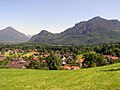
Brannenburg

Max Liebermann : Brannenburg Beer Garden, 1893

Lower stairs up to the pilgrimage church of St. Maria Magdalena on the Biber

View of the Wendelstein and the Mangfall Mountains from the foot of the Biber

View from the Biber towards Wendelstein - right halfway up St. Margarethen

Nagelfluh mining on the Biber - in the background the giant head

Traces of millstone mining can still be seen on a rock that was broken off


literature
- Sebastian Dachauer : Chronicle of Brannenburg and the nearest places in the area . In: Upper Bavarian Archive for Fatherland History , Volume 4, Munich 1843, Issue 1, pp. 92–135 ( online, without pp. 94–95 ); Issue 2, pp. 219-270 ( online ); Volume 3, pp. 326-329 ( online ); Volume 14, Munich 1853, Issue 2, pp. 1-39 ( online ).
- Sebastian Dachauer (Hrsg.): Regesten unprinted documents on Bavarian local, family and regional history . Tenth row: From the formerly Graef. Preysing'schen, now electoral prince. Maria Leopoldine registry of Brannenburg, and from the parish registry of this area . Munich 1846 (= Upper Bavarian Archive for Patriotic History Volume VIII, Issue 1) ( online, without pp. 1–3 ).
- Karfreit barracks: Helmut Pabst, "The Book of Brannenburg", Verlag Dipl.-Ing. Helmut Pabst, print: Oberbayerisches Volksblatt, 1975. “Brannenburger Gebirgspioniere”, pp. 4–7, publisher. Gebirgspionierbataillon 8, S1, WEKA Verlag, Pr. No. 83098067/5; 2001.
Web links
- Brannenburg community
- New artists' colony in Brannenburg
- Brannenburg: Official statistics of the LfStat
Individual evidence
- ↑ "Data 2" sheet, Statistical Report A1200C 202041 Population of the municipalities, districts and administrative districts 1st quarter 2020 (population based on the 2011 census) ( help ).
- ^ Members of the parish council. Municipality of Brannenburg, accessed on May 31, 2020 .
- ↑ http://www.brannenburg.de/winter/tourismus-freizeit/ortsinformationen/tatzelwurmstrasse/
- ↑ http://ecmaps.de/?hideSearch=true&experience=deutsche-alpenstrasse&inherit=_ecMaps_v5light#q=all%3Aall&lat=47.6883&lon=12.0153&z=13&id=91F4F9A025E35F6015FC3BEAA945B2D8 . &type= Tour
- ^ Evelin and Henning von Rochow: Brannenburg am Wendelstein. Kunstverlag Josef Fink, 2001, ISBN 3-933784-95-6 .
- ^ Brannenburg, Degerndorf: Chronicle and documentation of the Brannenburg community by Josef Rosenegger , editor: Brannenburg community, 1990, p. 194.
- ^ Municipality of Brannenburg in the local database of the Bavarian State Library Online . Bayerische Staatsbibliothek, accessed on August 20, 2018.
- ^ Sebastian Dachauer: Chronicle of Brannenburg and the nearest places in the area . In: Upper Bavarian Archive for Fatherland History , Volume 4, Munich 1843, Issue 1, pp. 92–135 ( online, without pp. 94–95 ) and Issue 2, pp. 219–270 ( online )
- ↑ Sebastian Dachauer : Simple story of the terrible fall of the Schrofenberg and the devastation it caused near Brannenburg in August 1851 . Munich 1852 ( online ).
- ↑ Canteens - Which beer? , Der Spiegel, 39/1956, September 26, 1956.
- ^ Wilhelm Volkert (ed.): Handbook of Bavarian offices, communities and courts 1799–1980 . CH Beck, Munich 1983, ISBN 3-406-09669-7 , p. 561 .
- ^ Federal Statistical Office (ed.): Historical municipality directory for the Federal Republic of Germany. Name, border and key number changes in municipalities, counties and administrative districts from May 27, 1970 to December 31, 1982 . W. Kohlhammer GmbH, Stuttgart / Mainz 1983, ISBN 3-17-003263-1 , p. 588 .
- ↑ a b c Local elections in Bavaria
- ^ Entry on the coat of arms of Brannenburg in the database of the House of Bavarian History

Albaching | Amerang | Aschau im Chiemgau | Babensham | Bad Aibling | Bad Endorf | Bad Feilnbach | Bernau am Chiemsee | Brannenburg | Breitbrunn am Chiemsee | Bruckmühl | Chiemsee | Edling | Eggstätt | Eiselfing | Feldkirchen-Westerham | Flintsbach am Inn | Frasdorf | Griesstätt | Großkarolinenfeld | Gstadt am Chiemsee | Halfing | Höslwang | Kiefersfelden | Kolbermoor | New building | Nussdorf am Inn | Oberaudorf | Pfaffing | Prien am Chiemsee | Prutting | Ramerberg | Raubling | Riedering | Rimsting | Rohrdorf | Rott am Inn | Samerberg | Schechen | Schonstett | Söchtenau | Soyen | Stephanskirchen | Tuntenhausen | Vogtareuth | Wasserburg am Inn
Unregulated areas in the district of Rosenheim
Rotter Forst-Nord |
Rotter Forst-Süd