
Amerang
| coat of arms | Germany map | |
|---|---|---|

|
Coordinates: 48 ° 0 ' N , 12 ° 19' E |
|
| Basic data | ||
| State : | Bavaria | |
| Administrative region : | Upper Bavaria | |
| County : | Rosenheim | |
| Height : | 537 m above sea level NHN | |
| Area : | 39.81 km 2 | |
| Residents: | 3659 (Dec. 31, 2019) | |
| Population density : | 92 inhabitants per km 2 | |
| Postal code : | 83123 | |
| Primaries : | 08075, 08074 | |
| License plate : | RO , AIB , WS | |
| Community key : | 09 1 87 113 | |
| Community structure: | 89 districts | |
| Address of the municipal administration: |
Wasserburger Str. 11 83123 Amerang |
|
| Website : | ||
| First Mayor : | Konrad Linner (GLA) | |
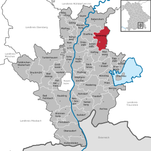
| Location of the community Amerang in the district of Rosenheim | ||
  |
||

Amerang is a municipality and a parish village in the Upper Bavarian district of Rosenheim .
geography
location
The municipality is located in the region of southeast Upper Bavaria in the Chiemgau . The village is located roughly in the middle between the Chiemsee (15 km) in the southeast and Wasserburg am Inn (10 km) in the northwest. The community of Amerang borders in the east on the community Obing and thus on the neighboring district of Traunstein .
Further around the village are Waldkraiburg (30 km N ), Trostberg (24 km E), Traunstein (34 km SE), Bad Endorf (10 km S) and Rosenheim (22 km SW):
Neighboring communities
| Eiselfing | Babensham | Schnaitsee |
| Schonstett |
.svg)
|
Obing |
| Halfing | Höslwang | Pittenhart |
Community structure
There are 89 districts:
Before March 1, 2012, Hillersöd was known as Höllersöd.
There are the districts Amerang, Evenhausen, Kirchensur and Unterratting.
history
Until the 19th century
Amerang was first mentioned in a document around the year 788. Amerang became an independent political municipality in the course of the administrative reforms in Bavaria in 1818. From the Middle Ages onwards, the history of the Amerang area is closely connected to the owners of Amerang Castle , the feudal lords of the Amerang court for the local population. Today's rulership has existed in one line for 23 generations. This was followed by the nobles of Amerang (12th and 13th centuries), the nobles of Laiming (14th and 15th centuries), the Italian noble family the Scaliger (16th century), the Counts of Lamberg (17th and 18th centuries) and from 1821 the barons of Crailsheim .
In 2014 Auer Packaging acquired the 50,000 m² technology park in the north of Amerang. When Robert Auer Kunststofftechnik founded 1985 in Kraiburg am Inn, the company now has its headquarters in Amerang. Euroboxes, bottle crates, tool cases and, with particularly heavy injection molding machines, also boxes the size of euro pallets are produced .
Incorporations
On January 3, 1870, the previously independent community of Unteratting was incorporated. On April 1, 1971 Evenhausen and Kirchensur were added. Parts of the neighboring municipality of Pittenhart ( district of Traunstein ) with around 40 inhabitants at that time followed on January 1, 1982.
Population development
Between 1988 and 2018 the municipality grew from 2,750 to 3,659 by 909 inhabitants or 33.1%.
politics
Municipal council
The municipal council consists of the first mayor and 16 council members for the 2020-2026 electoral period. The composition of the municipal council since the local elections in 2020 is as follows:
| * CSU | 6 seats |
| * FWK | 4 seats |
| * GLA | 6 seats |
mayor
First Mayor is Konrad Linner (GLA)
badges and flags
Blazon : Divided by silver and blue; above a horizontal red pliers, below a silver bar with a continuous black bar inside; these symbols are a reminder of the former local nobility. The colors silver and blue stand for the Bavarian national colors. The coat of arms has been used since 1969.
A white and blue flag with the municipality 's coat of arms is used as the unofficial municipal flag .
traffic
- The closest motorway junction with a distance of 24 km is at Bernau am Chiemsee in the south to the A8 . Rosenheim and Siegsdorf can be shorter in terms of route.
- The federal highway 304 runs 6 km north of the village.
- 12 km northwest of Amerang is Wasserburg am Inn with an Inn bridge on the Inn, which meanders here from SSW to NNE . At the time of the salt trade, Wasserburg was the port of Munich and was allowed to collect the salt disc penny, a levy on salt. The salt road ran in the area of today's B304. The Wasserburg power plant does not allow cyclists to cross the Inn, it does not have a lock for ships, but it does have a fish pass.
- Bus routes 9414, 9419 and 9492 connect you to Wasserburg am Inn , Schonstett , Halfing , Bad Endorf , Rimsting , Prien am Chiemsee , Rosenheim , Prutting , Söchtenau and Höslwang .
- On Sundays in the summer months, Amerang has been accessible again as a tourist train using the Chiemgauer local train since 2006 .
Culture and sights
- The Gothic parish church of St. Rupertus was completed in 1367 and redesigned in Baroque style in the 18th century.
Museums
- In the Amerang Farmhouse Museum, you can visit originally furnished farms from the period between 1525 and 1925 on an area of 40,000 m².
- EFA Mobile Zeiten is a multimedia collection on over 130 years of automotive history.
- In the summer months, Amerang Castle shows its salons and the Gothic castle chapel.
Concerts
- Concerts at Amerang Castle
- Around eight kilometers away in the direction of Halfing, the internationally known opera festival takes place at Gut Immling all year round.
music
- Formerly there was a recording studio in Kammer (near Amerang). Here albums (records / CDs) by Peter Kent ("It's a real good feeling"), Konstantin Wecker and other well-known artists were produced.
- The world music group " Quadro Nuevo " has Ameranger roots.
theatre
nature
- Amerang Castle Arboretum
- Orchard garden ( orchards , low- stem trees , conservation of endangered fruit varieties)
- Ameranger Moos , 2 km to the west, moor landscape around Ameranger and Zillhamer See. There are educational trails that are also suitable for cycling and jogging. The flora and fauna and the former peat cutting are explained on boards .
- The Friedlsee, approx. 3 km north of the village, between Amerang and Evenhausen, is an approx. 400 m long moor lake with a bathing area and a jetty.
- In the south, in the direction of Pelham, the Eggstätt-Hemhofer lake district is 8 km away . Numerous lakes, surrounded by moors and forests, emerged from the dead ice pools of the last glacier entry (approx. 120,000 years ago). The lake landscape borders immediately to the north on the Chiemsee.
- About 10 km to the east is the Seeon Lake District around the Seeon Abbey.
Personalities
- Ildefons (Andreas) Flötzinger (1878–1952), Missionary Benedictine , martyr of Tokwon
- Heinrich Stulberger (1902 – after 1970), District Administrator from 1948 to 1970, ran a farm in the community from 1925
- Ernst Freiberger sen. (1927–1997), entrepreneur (EFA-Eiskrem), founder of the EFA-Museum for German Automobile History (honorary citizen of Amerang)
- Ernst Freiberger jun. (* 1950), entrepreneur (formerly Freiberg food, Medical Park clinics)
- Franz Josef Gießibl (* 1962), German physicist, pioneer of atomic force microscopy
Literature on the history of the village of Amerang and the current municipality
- Amerang: A contribution to the history of the village and community. Author, Dean Josef Dürnegger and senior teacher Hans Kneißl. Publisher: Catholic Parish Office Amerang, 1940, 208 pages. The oldest historical description of the village and the old parish.
- Homeland book for the anniversary "1200 years of Amerang". History of the castle, the village and the community. Published by: Municipality of Amerang 1989, 768 pages. Editor: Wolfgang Klautzsch
- Evenhausen 782–2002: A contribution to the history of the parish and the parish as well as the historical representation of 78 properties in the parish. Editor and author Konrad Linner sen. 2003, 377 pages.
- House and farm history 1366–2010. Historical representation of 240 properties in the municipality as well as the local history of Kirchensur and Stephanskirchen. Editor and author Konrad Linner sen. 2010, 505 pages.
- Historical description of the village of Pfaffing in the municipality of Amerang. Journal for Bavarian State History: Volume 73, 2010, pp. 736–739. Pfaffing was the benefice and residence of the pastor of Evenhausen until 1880.
Web links
- Amerang Municipality website
- History of the Hofmark Amerang
- Parish village Amerang in the local database of the Bavarian State Library Online . Bavarian State Library
- Amerang Castle
- Entry on the coat of arms of Amerang in the database of the House of Bavarian History
Individual evidence
- ↑ "Data 2" sheet, Statistical Report A1200C 202041 Population of the municipalities, districts and administrative districts 1st quarter 2020 (population based on the 2011 census) ( help ).
- ↑ a b c City Council - overview. Amerang Congregation, accessed May 15, 2020 .
- ^ Community Amerang in the local database of the Bayerische Landesbibliothek Online . Bavarian State Library, accessed on December 18, 2017.
- ↑ Amerang parish: History of the Amerang parish. Accessed on March 29, 2020 : “The first documentary mention of Amerang can be found around 788 in the Salzburg register of goods“ Breves Notitiae ”. It speaks of "Amarwange". "
- ^ Josef Dürnegger and Hans Kneißl: Amerang - A contribution to the history of place and community . Catholic rectory, Törwang 1940.
- ↑ Company: Via Auer Packaging auer-packaging.com, accessed March 4, 2020.
- ^ Wilhelm Volkert (ed.): Handbook of Bavarian offices, communities and courts 1799–1980 . CH Beck, Munich 1983, ISBN 3-406-09669-7 , p. 589 .
- ^ Federal Statistical Office (ed.): Historical municipality directory for the Federal Republic of Germany. Name, border and key number changes in municipalities, counties and administrative districts from May 27, 1970 to December 31, 1982 . W. Kohlhammer GmbH, Stuttgart / Mainz 1983, ISBN 3-17-003263-1 , p. 814 .
- ^ Entry on the Amerang coat of arms in the database of the House of Bavarian History
- ↑ Entry on Amerang on the website kommunalflaggen.eu
- ↑ Mella: Do you know Wasserburg? - Stadt - Historisches trampelpfade.com, October 19, 2011, accessed March 4, 2020.
- ↑ The Martyrs of Tokwon, Brother Ildefons (Andreas) Flötzinger ( Memento of the original from December 24, 2015 in the Internet Archive ) Info: The archive link was inserted automatically and has not yet been checked. Please check the original and archive link according to the instructions and then remove this notice. - ( Missionary Benedictines )

Albaching | Amerang | Aschau im Chiemgau | Babensham | Bad Aibling | Bad Endorf | Bad Feilnbach | Bernau am Chiemsee | Brannenburg | Breitbrunn am Chiemsee | Bruckmühl | Chiemsee | Edling | Eggstätt | Eiselfing | Feldkirchen-Westerham | Flintsbach am Inn | Frasdorf | Griesstätt | Großkarolinenfeld | Gstadt am Chiemsee | Halfing | Höslwang | Kiefersfelden | Kolbermoor | New building | Nussdorf am Inn | Oberaudorf | Pfaffing | Prien am Chiemsee | Prutting | Ramerberg | Raubling | Riedering | Rimsting | Rohrdorf | Rott am Inn | Samerberg | Schechen | Schonstett | Söchtenau | Soyen | Stephanskirchen | Tuntenhausen | Vogtareuth | Wasserburg am Inn
Unregulated areas in the district of Rosenheim
Rotter Forst-Nord |
Rotter Forst-Süd