
Obing
| coat of arms | Germany map | |
|---|---|---|

|
Coordinates: 48 ° 0 ' N , 12 ° 24' E |
|
| Basic data | ||
| State : | Bavaria | |
| Administrative region : | Upper Bavaria | |
| County : | Traunstein | |
| Management Community : | Obing | |
| Height : | 562 m above sea level NHN | |
| Area : | 43.75 km 2 | |
| Residents: | 4332 (Dec. 31, 2019) | |
| Population density : | 99 inhabitants per km 2 | |
| Postal code : | 83119 | |
| Area code : | 08624 | |
| License plate : | TS, LF | |
| Community key : | 09 1 89 133 | |
| LOCODE : | DE OBX | |
| Community structure: | 60 districts | |
| Address of the municipal administration: |
Kienberger Str. 5 83119 Obing |
|
| Website : | ||
| Mayor : | Josef Huber ( FW ) | |
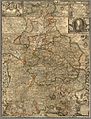
| Location of the community Obing in the district of Traunstein | ||
  |
||

Obing is a municipality in the Upper Bavarian district of Traunstein and the seat of the administrative community Obing , which includes the municipalities of Obing, Pittenhart and Kienberg .
geography
The place is located in the foothills of the Chiemgau on Lake Obinger and about ten kilometers north of the Chiemsee.
Waters
The following bodies of water are located in the municipality:
- Obinger See (31.18 ha)
- Griessee (9.21 ha)
- Brunnensee - also known colloquially as Brunnsee - (5.88 ha)
- Pigeon Lake (3.5 ha)
The Griessee, the Brunnensee and the surrounding moors are part of the Seeoner Seen nature reserve .
The four lakes take up 49.77 hectares of the total of 61 hectares of water in the municipality.
Area distribution
Of the total of 4,375 hectares, 3,049 hectares are agricultural areas, a further 931 hectares are forest areas and 61 hectares are water areas. 192 hectares are construction areas, 120 hectares are traffic areas and 22 hectares are other areas.
Extreme points
The highest point in the community is the Scheitzenberg at 655 m ( 48 ° 0 ′ 27 ″ N , 12 ° 21 ′ 28.5 ″ E ), the lowest points are at 532 m at Griessee and Brunnensee.
The largest extension of the municipality in the north / south direction is approx. 8.7 km as the crow flies and approx. 10.3 km in the west / east direction as the crow flies. The northernmost point is 48 ° 3 '14 " N , 12 ° 25' 12.5" O , the southernmost at 47 ° 58 '34.5 " N , 12 ° 25' 58" O . The westernmost point is at 48 ° 0 '48.5 " N , 12 ° 19' 57.5" O , the most easterly at 47 ° 59 '39 " N , 12 ° 28' 5" O .
Neighboring communities
The neighboring communities within the Traunstein district are Schnaitsee in the northwest , Kienberg in the northeast , Altenmarkt an der Alz in the east, Seeon-Seebruck in the south and Pittenhart in the southwest . Amerang is added to the west from the Rosenheim district .
Community structure
The 60 districts of Obing:
|
|
|
|
The districts marked with "A" belonged to the independent municipality of Albertaich until January 1, 1972. The districts Eggerdach and Gröben, which formerly belonged to the Albertaich community, changed to the Amerang community at this time . The district Voglöd belonged to the independent municipality Rabenden until January 1st, 1975 .
climate
According to the effective climate classification, the municipality of Obing lies in the Central European transitional climate between the maritime climate zone (Cfb), also called the beech climate , and the boreal zone (Dfb), also called the snow-forest zone, with the following factors:
- C = warm temperate rainy climates : the coldest month has a mean temperature between 18 ° C and −3 ° C, the warmest month has a temperature above 10 ° C.
- D = Boreal snow-forest climates: The coldest month has a temperature of less than −3 ° C, the warmest month is over 10 ° C.
- f = Type fully humid climate : all months are humid.
- b = subtype: All months are below 22 ° C, but there are at least four months that are warmer than 10 ° C.
Historical cartography
- 1568: On Philipp Apian's Bavarian land plates, plate 19 shows the districts that are now part of the municipality: Albertaich , Diepersberg , Frabertzheim , Kaffterpaum , Obing , Perckhaim , Pfeffing
- 1663: On the Sacri Romani imperii circuli et electoratus Bavariæ tabula chorographica from 1663 are recorded: Diepersberg , Fraberzhaim , Obing , Perkhaim and Pfaffing
- 1792: On Franz Johann Joseph von Reilly's maps of the Duchy of Upper Bavaria, nursing courts Neuötting, Mörmosen , Craiburg, Cling, Trosburg, Julbach and the Hohenaschau and Wildenwart or the Burghausen Rentamt is on the Nro. 161 recorded by the Burghausen Rent Office: Albertaich , Diebersberg , Perkhaim and Pfaffing . Obing itself is missing.

Apian's Bavarian Land Tables - Plate 19
Bavariae tabula chorographica

Von Reilly's card of the Burghausen Rent Office - Nro. 161

Thomson Map of Bavaria 1814

Bavaria map from Meyers Konversationslexikon 1885/90

.jpg)


Noticeably, because of the post office that has moved to Frabertsham in maps from the 19th century, Frabertsham is sometimes preferred to the much larger town Obing, for example on the Thomson Map of Bavaria from 1814 and on the Bavaria map of the 2nd to 4th edition by Meyers Konversationslexikon (1885/90).
The original position sheets 720, 721, 743 and 744 show a large part of the Obingen municipality. The position sheet 743 is still from the recording from 1818 and drawing from 1839.
history
Stone and Hallstatt Period
A burial mound find near Großbergham already suggests that the area was settled in the Stone Age. In the Celtic Hallstatt period, the first roads on which salt and amber were transported lead through the municipality (see Reichenhaller and Güldene Salzstraße ).
Roman times

Several crossing Roman roads are also occupied for the municipality. A tombstone from the 2nd or 3rd century found in the cemetery in 1814 names a woman Iulia Avita, who set the stone for her daughter Maximia Maxima. At that time Obing was in the Roman province of Noricum and perhaps still belonged to the administrative area of Iuvavum (Salzburg).
Post-Roman History
After the destruction by the Huns, Bavarians settled there , to which a cemetery in the upper village and row graves in Talham and Pfaffing bear witness (6th century). According to the Breves Notitiae and the Indiculus of Archbishop Arno von Salzburg (788) in Obing ( Opinga ) there were around 20 houses from around 716 onwards . Around 985 a "Herrant de Opingin" is documented.
Castle and Hofmark Obing

At the latest the Falkensteiners built a castle on the so-called Schlossberg , which went to Prince Ludwig of Bavaria in 1247 .
Obing was a non-closed Hofmark of the Seeon monastery since 1662 , which was secularized with the monastery in 1803 . The initially planned political upgrade - the relocation of the Kling district court to Obing - was dropped after the king heard the costs that the renovation of Obing Castle would cause. So the lock was broken off instead.
In 1813 the place had 44 house numbers.
Church planting and incorporations
Obing became an independent political municipality in the course of the administrative reforms in Bavaria in 1818 .
On January 1, 1972, the previously independent community of Albertaich was incorporated.
Administrative community
The administrative community Obing was established in 1978 as part of the regional reform .
Population development
Between 1988 and 2018 the municipality grew from 3,252 to 4,294 by 1,042 inhabitants or 32%.
| Population development of Obing (1840-2015) | |||||||||||||||||
|---|---|---|---|---|---|---|---|---|---|---|---|---|---|---|---|---|---|
| 1840 | 1871 | 1900 | 1925 | 1939 | 1950 | 1961 | 1970 | 1987 | 1995 | 2001 | 2005 | 2010 | 2015 | ||||
| 1485 | 1687 | 2209 | 2428 | 2378 | 3379 | 2795 | 2920 | 3226 | 3678 | 3900 | 3942 | 3978 | 4114 | ||||
For the future development up to 2028 the demographic mirror for Bavaria applies .
Religions
Christianity history
It is difficult to answer exactly when Christianization should be scheduled for Obing. The grave finds and the typical early Christian patronage of St. Laurentius speak for an early mission. The size of the parish in 1195 indicates that it existed before the Seeon Monastery was founded in 994.
The first pastor of Obing is known by name from 1165 to 1174/1182. His name was Heinrich von Geren / Gern. In 1491 the parish church of St. Laurentius, newly built in the Gothic style, was consecrated. It was enlarged from 1868 to 1871.
Christian communities
The Roman Catholic parish of St. Laurentius Obing is now part of the Obing Parish Association in the Baumburg deanery of the Archdiocese of Munich and Freising .
The Johanniskirche in Obing, completed in 1999, belongs to the Evangelical Lutheran parish of Bad Endorf .
Religious affiliations
In the census of May 25, 1987, out of a total of 3,226 inhabitants, 2934 (90.9%) belonged to the Roman Catholic denomination, 192 (6%) to the Evangelical Lutheran denomination. On May 9, 2011, of 3959 inhabitants, 3082 (77.8%) stated to be Roman Catholic and 249 (6.3%) Protestant Lutheran.
traffic

Obing is on the busy federal highway 304 .
The railway line between Endorf (today Bad Endorf ) and Obing was planned and built in accordance with the Bavarian Local Railway Act. In September 1908, it opened as the Endorf - Obing local line. The operation was de facto ceased in 1996 by the Deutsche Bundesbahn, but the line has not been legally closed. A local railway initiative called for the line to be privatized and partially managed to resume passenger transport from 2006 (see Chiemgauer Lokalbahn )
There is also the project of a citizens' bus connecting Obing, Bad Endorf and Amerang .
politics
City council and mayor
The municipal council election on March 15, 2020 had the following official final result:
| CSU | FREE VOTERS | Obingen citizen list |
Political Alternative Obing |
total | |
|---|---|---|---|---|---|
| Seats | 6th | 3 | 4th | 3 | 16 |
Mayor has been Josef Huber (Free Voters) since May 1, 2014; he was elected for a further six years on March 15, 2020 with 96.6% of the vote.
coat of arms
The split coat of arms shows two intertwined black capital letters A in the first half. They are attributed to the coat of arms of the noble family of Obingen . The second half is divided five times to the left, alternating between gold and black. This was taken from the coat of arms of the Seeon abbot Columban Freidlsperger, who acquired the Hofmark Obing in 1662 for the Seeon monastery. The coat of arms has been used since 1969 by resolution of the municipal council and the consent of the State Ministry of the Interior.
Public facilities
Educational institutions
In the community there is a three-group church kindergarten in the village as well as an integrated kindergarten, the "Kinderstadl", in Liedering. The Obing community has a primary and secondary school.
Offices
The town hall Obing is the seat of the administrative community Obing.
Attractions
The three-aisled Gothic parish church of St. Laurentius has a neo-Gothic high altar with three carved figures by the Master von Rabenden : Madonna and Child, St. Laurentius and St. James (1515). The church was consecrated in 1492 and extended to the west by two yokes in the 19th century .
The St. Michael cemetery chapel was built in 1870.
See also: List of architectural monuments in Obing
Soil monuments
See: List of archaeological monuments in Obing

High altar with the three main figures of the master von Rabenden

Parish Church of St. Laurentius
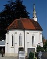
St. Michael cemetery chapel


Individual evidence
- ↑ "Data 2" sheet, Statistical Report A1200C 202041 Population of the municipalities, districts and administrative districts 1st quarter 2020 (population based on the 2011 census) ( help ).
- ↑ Map view and data of the Seeon Lakes nature reserve . Geospatial services of the Federal Agency for Nature Conservation. Retrieved May 9, 2014.
- ^ Obing community in the local database of the Bavarian State Library Online . Bayerische Staatsbibliothek, accessed on January 4, 2018.
- ↑ Original position sheet 720 at www.bayerische-landesbibliothek-online.de
- ↑ Urpositionsblatt 721 on www.bayerische-landesbibliothek-online.de
- ↑ Original position sheet 743 at www.bayerische-landesbibliothek-online.de
- ↑ Original position sheet 744 at www.bayerische-landesbibliothek-online.de
- ^ Walter Mayer, Weg-Geschichte im "Obinggau" ( Memento from October 21, 2017 in the Internet Archive )
- ↑ CIL 03.05586 ; the tombstone is now in the Grünwald Castle Museum ; for pictures see tomb altar of Maximia Maxima at ubi-erat-lupa.org ; the epigraphic database Heidelberg has the inscription under the number HD042394 .
- ↑ image of the local sheet of 1813 on www.bayerische-landesbibliothek-online.de
- ^ Wilhelm Volkert (ed.): Handbook of Bavarian offices, communities and courts 1799–1980 . CH Beck, Munich 1983, ISBN 3-406-09669-7 , p. 581 .
- ↑ Bavarian State Office for Statistics, Statistics communal 2015, Obing municipality at www.statistik.bayern.de
- ↑ Calculations for the municipality of Obing until 2028 at www.statistik.bayern.de
- ↑ Parish of St. Laurentius Obing on www.erzbistum-muenchen.de
- ↑ Johanniskirche in Obing ( Memento of the original from March 3, 2017 in the Internet Archive ) Info: The archive link was inserted automatically and has not yet been checked. Please check the original and archive link according to the instructions and then remove this notice. at bad-endorf-evangelisch.de
- ↑ Bavarian State Office for Statistics, Statistics communal 2015, Obing municipality at www.statistik.bayern.de
- ↑ History of the coat of arms of Obing at www.hdbg.eu
Web links
- Entry on Obing's coat of arms in the database of the House of Bavarian History

Altenmarkt an der Alz | Mountains | Chieming | Engelsberg | Fridolfing | Grabenstätt | Grassau | Inzell | Kienberg | Kirchanschöring | Marquartstein | Nussdorf | Obing | Palling | Petting | Pittenhart | Reit im Winkl | Ruhpolding | Schleching | Schnaitsee | Seeon-Seebruck | Siegsdorf | Staudach-Egerndach | Surberg | Tacherting | Taching at the lake | Tittmoning | Traunreut | Traunstein | Trostberg | Overseas | Unterwössen | Vachendorf | Waging am See | Wonneberg
Unregulated areas: Chiemsee | Waginger See