Obinger See
| Obinger See | ||
|---|---|---|

|
||
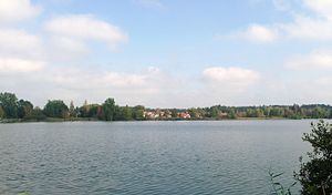
| The Obingen lake from the south with the Obingen district Pfaffing on the opposite bank | ||
| Geographical location | District of Traunstein , Bavaria | |
| Tributaries | Moosmühlbach | |
| Drain | Obinger Seebach → (dry valley along the B 304 ) → Alz → Inn → Danube → Black Sea | |
| Places on the shore | Obing | |
| Data | ||
| Coordinates | 48 ° 0 '11 " N , 12 ° 24' 56" E | |
|
|
||
| Altitude above sea level | 556 m | |
| surface | 31.18 ha | |
| length | 890 m | |
| width | 420 m | |
| volume | 2,180,000 m³ | |
| scope | 2.3 km | |
| Maximum depth | 15 m | |
| Middle deep | 7 m | |
The Obinger See is a lake near Obing in the Traunstein district in Bavaria.
It has an area of 31.18 hectares and a depth of up to 15 m (according to other information up to 18 m). The Obinger Seebach drains the lake via the Alz , the Inn into the Danube . The main tributary is the approximately 3.7 kilometers long Moosmühlbach, which flows into the west bank in Obing . The runoff occurs to the east via the Obinger Seebach, then further without surface water in a dry valley along the route of the B 304 to the Alz near Altenmarkt an der Alz .
The Obinger See is valued by anglers for its abundance of fish. The following fish species occur in it:
- Open water zone: pikeperch , lake trout , rainbow trout , arctic char , whitefish (Coregonus sp.), Mairenke
- Bottom zone: perch , pond mussel and brook mussel
The plants at Lake Obingen include reed , white water lily , yellow pond rose , flooding buttercup and thunderbolt .
Since the summer of 1998 there has been a sculpture trail around Lake Obingen, which was designed by well-known contemporary artists such as Andreas Kuhnlein , Marco Bruckner and Hans Thurner .
