
Alz
| Alz | ||
 |
||
| Data | ||
| Water code | EN : 184 | |
| location | Bavaria , Germany | |
| River system | Danube | |
| Drain over | Inn → Danube → Black Sea | |
| source |
Chiemsee near Seebruck 47 ° 55 ′ 58 ″ N , 12 ° 28 ′ 48 ″ E |
|
| Source height | 518 m above sea level NN | |
| muzzle | near Marktl in the Inn Coordinates: 48 ° 16 ′ 13 ″ N , 12 ° 49 ′ 3 ″ E 48 ° 16 ′ 13 ″ N , 12 ° 49 ′ 3 ″ E |
|
| Mouth height | 360 m above sea level NN | |
| Height difference | 158 m | |
| Bottom slope | 2.5 ‰ | |
| length | 63 km , with the upper reaches from Kitzbüheler Ache and Tiroler Achen 150 km | |
| Catchment area | 2,238.6 km² | |
| Discharge at the Altenmarkt or T. A Eo gauge : 1552 km² Location: 45.3 km above the mouth |
NNQ (07.10.1947) MNQ 1931/2006 MQ 1931/2006 Mq 1931/2006 MHQ 1931/2006 HHQ (12.06.1965) |
9.1 m³ / s 19.6 m³ / s 53.3 m³ / s 34.3 l / (s km²) 144 m³ / s 329 m³ / s |
| Outflow at the Burgkirchen A Eo gauge : 2222 km² Location: 15.3 km above the mouth |
NNQ (14.10.1984) MNQ 1973–2006 MQ 1973–2006 Mq 1973–2006 MHQ 1973–2006 HHQ (12.08.2002) |
7.88 m³ / s 27.5 m³ / s 68.5 m³ / s 30.8 l / (s km²) 258 m³ / s 481 m³ / s |
| Discharge at the mouth (without discharge into the Alz Canal ) A Eo : 2,238.6 km² |
MQ Mq |
68.8 m³ / s 30.7 l / (s km²) |
| Left tributaries | Ischler Achen | |
| Right tributaries | Traun , Halsbach (Alz) | |
| Small towns | Trostberg | |
| Communities | Emmerting , Garching adAlz , Burgkirchen adAlz , Altenmarkt , Tacherting , Seeon-Seebruck | |
The Alz is the outflow of the Chiemsee . It leaves the Chiemsee at the northernmost point at Seebruck and flows into the Inn after 63 km at the Alzspitze, about 2.5 km northwest of Marktl . If you add the Tiroler Achen, which flows 8 km south into the Chiemsee (79 km, with the source river Kitzbühler Ache ), the total length is 150 km. Its natural mean discharge (without water drainage) would be about 69 m³ / s, making the Alz (after the Salzach ) the second largest tributary of the Inn.
A distinction is made between the Obere Alz , the section from Chiemsee to Altenmarkt with the approximately 2 meter high natural waterfall and the Lower Alz , which, reinforced by the largest tributary, the Traun , extends from Altenmarkt to the confluence with the Inn.

Recent / Sub-recent freshwater oncoids in the Upper Alz

The Obere Alz is a warm summer, cold winter and lime-rich river, in which freshwater oncoids and oncolith formation (limestone surfaces / limestone cliffs) occur in some favorable places . The Chiemsee serves the river as an upstream buffer in terms of water flow (quantity) and sediment flow. The seasonal floods with strong turbidity / sedimentation of the Tiroler Ache , on the one hand when the snow melts in spring, and on the other hand during long periods of rain in summer, reach the Alz in a significantly softened manner. Without this buffering, the occurrence / growth of the oncoids would not be possible, because suitable conditions are only given with a suitable flow rate, light (low turbidity) and heat. Extensive areas with oncoid and oncolith are documented, especially in the uppermost section to Truchtlaching (low gradient / low flow velocity).
The limestone layer that grows on the nuclei (nucleus), fluvio-glacial rubble, is formed by calcifying cyanobacteria. Layer thicknesses of several centimeters are not uncommon. By laying out marked nuclei (growth experiment) and observing them over several years, the in situ growth of the Alz oncoids could be demonstrated.
burden
In the area of the Lower Alz, the river is characterized by heavy industrial use on its way through the Bavarian Chemical Triangle . From Trostberg onwards , only a fraction of the amount of water is left in the original bed due to multiple canal diversions. In the Burgkirchen area, for example, the mean flow rate of the Alz is 12.7 m³ / s, in the Alz Canal it is around 55 m³ / s (up to 75 m³ / s). The diverted water is mainly used as cooling and process water and to generate electrical energy. Large power plants are located in Laufenau and at the waterfall near Altenmarkt , Trostberg, Wajon near Tacherting , Wald near Garching , Hirten near Burgkirchen and north of Burghausen . The Alz Canal does not flow into the Inn like the Alz, but into the Salzach near Burghausen.
Overall, the water quality has improved significantly since the 1980s. A major contribution to this is made by the modernization and new construction of sewage treatment plants that the Alz use as receiving waters . One of the largest of these projects was the circular sewer system, which went into operation in 1989, for all of the areas bordering the Chiemsee. The discharges of pollutants through the industry decreased on the one hand through optimized use of the process water and its cleaning, on the other hand also through changed product ranges. Nevertheless, in autumn 2006, the Fraunhofer Institute for Molecular Biology and Applied Ecology (IME), Aachen, measured perfluorooctanoic acid in concentrations of up to 56.1 μg / l and perfluorooctanesulfonic acid in concentrations of up to 14.1 ng / l below Gendorf .
tourism
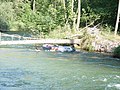
The Obere Alz has tourist significance for water hikers due to its relatively calm course. In the period from July 1st to October 31st, it is possible to sail the river from Seebruck to above the Alz waterfall near Altenmarkt with boats, especially rubber dinghies. When the weather is nice, boats are particularly busy on weekends.
With an average flow of around 44 m³ / s, the Alzfall is the most water-rich natural waterfall in Germany.
Despite the mostly simple flow conditions, there are dangers from trees and rocks lying in the river bed.
The Mühlbach branched off from the Alz serves as a "free swimming channel" on a stretch through the Trostberg outdoor pool .

The Obere Alz at the weir in the Hölltal

The bristle ramp in Truchtlaching
The Alz can also be dangerous

Cataract near Altenmarkt


Web links
- The Alz on www.wwa-ts.bayern.de ( Memento from July 23, 2010 in the Internet Archive )
- Greenpeace: Maximum levels of chemicals in the Bavarian river
Individual evidence
- ↑ Directory of creek and river areas in Bavaria - Inn river area, page 55 of the Bavarian State Office for the Environment, as of 2016 (PDF; 2.8 MB)
- ^ Deutsches Gewässerkundliches Jahrbuch Danube region 2006 Bavarian State Office for the Environment, p. 244, accessed on October 4, 2017, at: bestellen.bayern.de (PDF, German, 24.2 MB).
- ^ Deutsches Gewässerkundliches Jahrbuch Danube Region 2006 Bavarian State Office for the Environment, p. 245, accessed on October 4, 2017, from: bestellen.bayern.de (PDF, German, 24.2 MB).
- ↑ Seebruck gauge value increased by the area discharge (12.8 l / s.km²) of the remaining catchment area (467.3 km²), determined for the enclosing intermediate catchment area of the gauges Ruhstorf (Rott), Wasserburg (Inn), Seebruck , Stein bei Altenmarkt (Traun) ), Burghausen (Salzach), Jahrsdorf (Mattig), Mamling (Ach), Pramerdorf (Pram) and Passau-Ingling (Inn)
- ↑ a b D. Hägele: Morphogenesis, growth and ecology of the modern freshwater oncoids of the Alz. 2006
- ↑ E. Rott: The algae growth in the Upper Alz (Upper Bavaria). 1994
- ↑ Fraunhofer Institute - Investigation of perfluorinated surfactants in water
- ↑ Note: The water- richer Lechfall near Füssen is a weir.