
Emmerting
| coat of arms | Germany map | |
|---|---|---|

|
Coordinates: 48 ° 12 ' N , 12 ° 46' E |
|
| Basic data | ||
| State : | Bavaria | |
| Administrative region : | Upper Bavaria | |
| County : | Altötting | |
| Management Community : | Emmerting | |
| Height : | 390 m above sea level NHN | |
| Area : | 14.09 km 2 | |
| Residents: | 4150 (Dec. 31, 2019) | |
| Population density : | 295 inhabitants per km 2 | |
| Postal code : | 84547 | |
| Area code : | 08679 | |
| License plate : | AÖ, LF | |
| Community key : | 09 1 71 114 | |
| Community structure: | 4 districts | |
| Address of the municipal administration: |
Untere Dorfstrasse 3 84547 Emmerting |
|
| Website : | ||
| First Mayor : | Stefan Kammergruber (CSU) | |
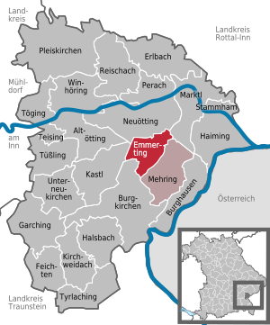
| Location of the municipality of Emmerting in the Altötting district | ||
  |
||

Emmerting is a municipality in the Upper Bavarian district of Altötting and a member of the administrative community of the same name .
geography
The seat of the municipal administration and the largest town is Unteremmerting , with which Seng and Oberemmerting have merged structurally.
Community structure
Emmerting has four districts:
In addition to the only inhabited district of Emmerting, which roughly corresponds to the municipality in its original limits, there are the districts of Altöttinger Forst , Alzgerner Forst and Holzfelder Forst . The latter are formerly unincorporated areas that were dissolved at different times and distributed to several communities:
- Altöttinger Forst , on January 1st, 1998 divided between Altötting , Burgkirchen adAlz , Emmerting and Kastl
- Alzgerner Forst , split between Emmerting and Neuötting on January 1st, 2001
- Holzfelder Forst , split between Mehring , Emmerting and Burghausen on January 1st, 2001
history
Until the church is planted
Emmerting was first mentioned in a document in 815 as a former husband in an exchange contract with the Bishop of Salzburg. Emmerting was part of the Burghausen Rent Office and the Neuötting Regional Court of the Electorate of Bavaria . In the course of the administrative reforms in Bavaria , today's municipality was created with the municipal edict of 1818 .
19th and 20th centuries
The place is recorded on maps from the 19th to the 20th century as Egmating .
In 1960 Emmerting became its own parish. At the end of the regional reform , Emmerting and Mehring merged on May 1, 1978 to form the Emmerting administrative association .
Outsourcing
In 1955 the district of Gendorf with its industrial park was spun off to Burgkirchen an der Alz .
Population development
Between 1988 and 2018 the municipality grew from 3,403 to 4,158 by 755 inhabitants or by 22.2%.
| year | 1970 | 1987 | 1991 | 1995 | 2000 | 2005 | 2010 | 2015 |
| Residents | 2005 | 3285 | 3625 | 3894 | 3957 | 4037 | 4138 | 4130 |
politics
mayor
Mayor is Stefan Kammergruber (CSU). He was elected in the 2014 local elections with 91.1% of the valid votes and was confirmed in office for a further six years on March 15, 2020 with 94.6% of the votes.
Municipal council
The municipal council has 16 members. The last municipal council elections on March 16, 2014 and March 3, 2008 brought the following results:

| Parties | 2014 | 2008 | ||||
|---|---|---|---|---|---|---|
| proportion of | Seats | ± proportion | ± seats | proportion of | Seats | |
| CSU | 50.8% | 8th | + 4.2% | ± 0 | 46.6% | 8th |
| SPD | 12.5% | 2 | + 2.2% | +1 | 10.3% | 1 |
| Green | 9.1% | 2 | + 2.7% | +1 | 6.4% | 1 |
| Free voters | 27.6% | 4th | −9.1% | −2 | 36.7% | 6th |
| voter turnout | 51.4% | −14.9% | 66.3% | |||
Another member and chairman of the municipal council is the 1st mayor.
coat of arms
Blazon of the coat of arms introduced in 1982: Under a red shield head with a silver post, split by blue and silver, a silver bridge growing out of a silver corrugated shield in front, a green oak leaf with an acorn in the back.

Attractions
The Catholic parish church of the Holy Spirit is a modern cubic structure with a free-standing tower. It was built from 1965 to 1967 according to plans by the architect Karl Habermann and is furnished by Wolf Hirtreiter .
See also: List of architectural monuments in Emmerting and List of ground monuments in Emmerting
Economy and Infrastructure
economy
In 2014, according to official statistics, there were 101 employees in the manufacturing sector and 44 in trade, transport and hospitality at the place of work. In other economic sectors there were 144 people. There were 1712 employees at the place of residence subject to social security contributions. There were none in the manufacturing sector and three in the construction sector. In addition, there were seven agricultural holdings in 2010 with a total of 142 ha of agricultural land, of which 89 ha were arable land and 53 ha were permanent green space.
education
In 2015 the following institutions existed:
- Kindergartens: two facilities, 150 kindergarten places with 130 children
- Primary school: one with 14 teachers and 228 students
Since the minimum number of pupils required to form a school class was no longer achieved due to the lower number of pupils, the Emmerting-Mehring elementary school was dissolved in 2009 and the main pupils were distributed to the surrounding main schools in Burghausen and Burgkirchen. The primary school in Emmerting remained.
Personalities
- Michael Wiesinger (* 1972), soccer player and coach
- Julian Pollersbeck (* 1994), soccer goalkeeper
Web links
Individual evidence
- ↑ "Data 2" sheet, Statistical Report A1200C 202041 Population of the municipalities, districts and administrative districts 1st quarter 2020 (population based on the 2011 census) ( help ).
- ↑ Mayor. Municipal Council, accessed June 17, 2020 .
- ^ Emmerting in the local database of the Bayerische Landesbibliothek Online . Bavarian State Library, accessed on December 23, 2017.
- ↑ RABI No. 26 v. November 14, 1997
- ↑ Upper Bavarian Official Journal, No. 21 v. November 3, 2000
- ↑ Upper Bavarian Official Journal, No. 21 v. November 3, 2000
- ↑ Special map 1: 75,000 , recording sheet of the 3rd Austrian regional survey , 1939
- ^ Position sheet 1: 25,000 , Bavarian first recording 1817–1841
- ^ Entry on the Emmerting coat of arms in the database of the House of Bavarian History

Altötting | Burghausen | Burgkirchen an der Alz | Emmerting | Erlbach | Feichten an der Alz | Garching an der Alz | Haiming | Halsbach | Kastl | Kirchweidach | Marktl | Mehring | Neuötting | Perach | Pleiskirchen | Reischach | Stammham | Teising | Töging am Inn | Tüßling | Tyrlaching | Untereukirchen | Winhöring