Teising
| coat of arms | Germany map | |
|---|---|---|

|
Coordinates: 48 ° 14 ' N , 12 ° 37' E |
|
| Basic data | ||
| State : | Bavaria | |
| Administrative region : | Upper Bavaria | |
| County : | Altötting | |
| Height : | 405 m above sea level NHN | |
| Area : | 5.38 km 2 | |
| Residents: | 1870 (Dec. 31, 2019) | |
| Population density : | 348 inhabitants per km 2 | |
| Postcodes : | 84576, 84503 | |
| Area code : | 08633 | |
| License plate : | AÖ, LF | |
| Community key : | 09 1 71 131 | |
| Community structure: | 5 districts | |
| Address of the municipal administration: |
Hauptstrasse 7 84576 Teising |
|
| Website : | ||
| First Mayor : | Johann Hiebl (Teisinger List) | |
| Location of the municipality of Teising in the Altötting district | ||
Teising is a municipality in the western district of Altötting ( administrative district of Upper Bavaria ).
geography
Geographical location
Teising is located in the Southeast Upper Bavaria region between the towns of Altötting and Mühldorf am Inn, directly on the state road 2550 (formerly the B 12 ).
The Inn flows through the municipality of Teising.
Community structure
Teising has five districts:
- Gschwandtner
- Holzhauser Eck
- Lohberg
- Teising
- Wide field
There is only the Teising district .
history
Already in the Celtic times people settled in the forests around Teising, which is indicated by a Celtic hill below the place. In Roman times, two Roman roads crossed near Teising, one of which followed the course of today's Inn and Waldstrasse to a crossing in the direction of Töging. Teising was first mentioned in a document as "Tisingen" in 710, making it the oldest municipality in the Altötting district. Teising belonged to the Burghausen Rent Office and the Neuötting Regional Court of the Electorate of Bavaria . In 1818 the Raitenhart community was founded with Teising and Unterholzhausen as a rural community. It was divided into the two communities Raitenhart and Teising by a resolution of the Ministry of the Interior on July 17, 1833. In 1885 the volunteer fire brigade was founded. Until 1955 Teising was self-sufficient in terms of energy technology thanks to its own power station. Half of the community has been in a water protection area since the 1980s. As a result of the construction of the A 94 motorway, the B 12 federal road that formerly ran through the town was downgraded to state road 2550. This enabled the town center to be redesigned. Further confluences into the main street from the settlements (via Ahornstrasse and Blumenstrasse) have been politically delayed until today, so that Teising still consists of two separate urban hoses north and south of the former B 12.
Administrative community
In 1978 the administrations of the municipality of Tüßling and the municipality of Teising were merged to form the Tüßling administrative community. This administrative community was dissolved again with effect from January 1, 1998 at the request of the municipality of Teising.
Population development
At the beginning of the Second World War, Teising had fewer than 400 inhabitants. After the Second World War , there was a brief influx of refugees, but in the 1960s the population fell back to around 550. Only then did the mayor and gravel pit owner Josef Bachmeier rapidly increase the number of building areas.
Between 1988 and 2018, the community grew from 1,568 to 1,870 by 302 inhabitants or 19.3%.
- 1970: 846 inhabitants
- 1987: 1477 inhabitants
- 1991: 1697 inhabitants
- 1995: 1856 inhabitants
- 2000: 1987 inhabitants
- 2005: 1932 inhabitants
- 2010: 1868 inhabitants
- 2015: 1913 inhabitants
religion
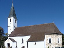
Teising belongs to the parish of Burgkirchen am Wald. In the local church consecrated to St. John the Baptist there is an evening service every Saturday.
politics
mayor
Mayor is Johann Hiebl (Teisinger List). He was the successor to Josef Bachmeier (CSU / Frei without party) in 2002 and was most recently re-elected on March 15, 2020 with 65.0% of the vote.
Municipal council
After the local elections on March 15, 2020 , the local council has twelve members. The turnout was 66.50% (2014: 54.41%). The choice brought the following result:
| Teisinger List | 5 seats | (38.1%) | |
| CSU | 4 seats | (33.4%) | |
| Free voters | 3 seats | (28.4%) |
In the election on March 16, 2014, the CSU and Teisinger List ran with a joint nomination and won 9 seats; the free voters had 3 seats.
Another member and chairman of the municipal council is the mayor.
Culture and sights
- Village church of St. John the Baptist : Gothic, 15th century, renovated in 2009
- Old fire station with Lüftlmalerei
- West facade of the riding stables (unfortunately in desolate condition)
- Steam threshing machine on Teisinger Bach (Mühlenstraße)
- Foundations of the railway bridge over the Teisinger Bach of the former Mühldorf-Alte Bahn-Altötting railway line (between Heiligenstätter Straße and Kirchenweg)
See also: List of architectural monuments in Teising and List of ground monuments in Teising
Economy and Infrastructure
Economy including agriculture and forestry
In 1998, according to official statistics, there were no employees at the place of work in the manufacturing industry or in trade and transport who were subject to social insurance contributions. In other economic sectors 40 people were employed at the place of work subject to social security contributions. There were a total of 651 employees at the place of residence subject to social security contributions. There were seven companies in the manufacturing sector and four in the construction sector. In addition, in 1999 there were 16 farms with an agricultural area of 345 ha, of which 259 ha were arable land and 86 ha were permanent green space. With ALRA Handels GmbH, there has also been a local specialist shop for spirits and wine since 1996.
traffic
State road 2550 (formerly B 12 ) runs through Teising. There is a regular bus service to Altötting and Mühldorf.
Data network
All 806 households have network access with a bandwidth of up to 2000 kbit per second.
education
There are the following institutions (as of 2018):
- Daycare center with 85 approved places and 73 children, 11 of them under 3 years of age
- Elementary school with five teachers, four classes and 75 students
- Multipurpose hall
- Sports home, two soccer fields, tennis courts
Individual evidence
- ↑ "Data 2" sheet, Statistical Report A1200C 202041 Population of the municipalities, districts and administrative districts 1st quarter 2020 (population based on the 2011 census) ( help ).
- ↑ a b PNP of January 31, 2009: "Teising is no longer on the B12"
- ^ Community Teising in the local database of the Bavarian State Library Online . Bavarian State Library, accessed on December 23, 2017.
- ↑ a b Landkreis Altötting Kreisheimatpflege: "Katholische Filialkirche St. Johann Baptist" ( Memento of the original from May 16, 2011 in the Internet Archive ) Info: The archive link was automatically inserted and not yet checked. Please check the original and archive link according to the instructions and then remove this notice.
- ↑ Fifth law amending the structure of municipalities and administrative communities of July 26, 1997 ( GVBl p. 309)
- ↑ Description of the broadband situation in the municipality of Teising (PDF; 7 kB)
Web links
- Entry on the coat of arms of Teising in the database of the House of Bavarian History


