Winhöring
| coat of arms | Germany map | |
|---|---|---|

|
Coordinates: 48 ° 16 ' N , 12 ° 39' E |
|
| Basic data | ||
| State : | Bavaria | |
| Administrative region : | Upper Bavaria | |
| County : | Altötting | |
| Height : | 389 m above sea level NHN | |
| Area : | 24.58 km 2 | |
| Residents: | 4785 (Dec. 31, 2019) | |
| Population density : | 195 inhabitants per km 2 | |
| Postal code : | 84543 | |
| Area code : | 08671 | |
| License plate : | AÖ, LF | |
| Community key : | 09 1 71 137 | |
| Community structure: | 38 districts | |
| Address of the municipal administration: |
Obere Hofmark 7 84543 Winhöring |
|
| Website : | ||
| Mayor : | Karl Brandmüller ( CSU ) | |
| Location of the municipality of Winhöring in the Altötting district | ||

Winhöring ( Bavarian : Win (n) àring) is a municipality in the Upper Bavarian district of Altötting .
geography
Geographical location
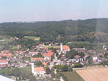
Winhöring is located in the foothills of the Alps in the region of southeast Upper Bavaria , on the edge of the Lower Bavarian hill country in the triangle of mouth between Isen and Inn . The place is about 90 km east of the state capital Munich , 85 km southwest of Passau and about 70 km northwest of Salzburg , in the immediate vicinity of the district towns of Altötting and Mühldorf am Inn in the Inn-Salzach tourist region .
The town center lies on a plain between the Isen and Inn valleys. North of the Isen, the tertiary hill country (wood country) rises within the town limits to up to 470 m above sea level. NN and forms the northern border of the Isar-Inn gravel plate . Some districts, primarily courtyards and hamlets, are already located in the hilly country and thus geographically separated from the Isen and Inn valleys.
The Isen floods regularly. Before flood protection measures were implemented, this often led to major damage to the buildings, for example in 1954 (see also flood 1954 ).
Neighboring communities
In the south, the Inn forms the natural border with the neighboring towns of Alt- and Neuötting . In the west Winhöring borders on the town of Töging am Inn , in the north on Pleiskirchen and Reischach in the east.
Community structure
Winhöring has 38 districts:
|
Waters
|
history
Until recently it was assumed that Winhöring was first mentioned as "Uuiniheringa" in 953 as a papal property. In documents from the bishops of Freising , however, a donation in Winhöring is mentioned as early as February 13, 816. For a long time Winhöring was the seat of a Hofmark that had belonged to the Counts of Toerring- Jettenbach since 1721 . Winhöring became an independent political municipality in the course of the administrative reforms in Bavaria in 1818 . Up until the post-war period, Winhöring was dominated by agriculture, with only a few larger production companies located in the Eisenfelden district. Today Winhöring is mainly a residential community with a strong club life and many families.
Incorporations
On January 1, 1967, parts of the dissolved community of Eggen were incorporated into Winhöring.
Population development
Between 1988 and 2018, the municipality grew from 4,584 to 4,801 by 217 inhabitants or 4.7%.
religion
About 90% of the community's population is Catholics. The Catholic parish of St. Peter and Paul is subordinate to the Altötting deanery and belongs to the diocese of Passau . In addition to the parish church of St. Peter and Paul , two other church buildings are affiliated to the parish : The field church of Mariä Namen is located in the cemetery on the southern edge of the town, the chapel of St. Bartholomew in the Burg district is the relic of a medieval castle complex. Smaller devotions are held in both branch churches, e.g. B. May devotions .
politics
mayor
Karl Brandmüller (CSU) has been mayor since September 28, 2017, who prevailed over two opposing candidates with 51.6% of the vote. His predecessor Hans Daferner (CSU) had resigned. Brandmüller was confirmed without competitors on March 15, 2020 with 94.2% of the votes for a further six years.
Municipal council
The Winhöringen municipal council has 16 members. It meets once a month and, following the local elections on March 15, 2020, has been composed as follows since May 1, 2020:
| CSU | SPD | Free voters "community welfare" |
|---|---|---|
| 9 seats | 3 seats | 4 seats |
Partnerships
A partnership with the Austrian municipality of Pernegg ad Mur in Styria has existed since 2003 .
coat of arms
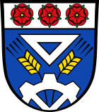
Blazon : Under a silver head of a shield, inside three red heraldic roses with golden lugs next to each other, in blue above a half silver cogwheel growing from the lower edge of the shield, a silver angle, accompanied on both sides by a golden ear.
Attractions
- Parish Church of St. Peter and Paul
-
Vicarage
The parsonage, which is worth seeing and unique in Eastern Bavaria , was built in 1728 by the pastor Stadler. The associated economy was demolished at the end of the 1960s and instead a house was built for the pastor, without showing any sense of the beautiful ensemble. Nevertheless, the courtyard with a wall facing Neuöttinger Strasse was essentially preserved. The buildings on the north side u. a. a two-storey open arbor with domed turret have been renovated in an exemplary manner in recent years and serve as meeting and group rooms for the parish. In addition, the community library could be housed in the premises. - Field church
- Frauenbühl Castle
- Castle keep
- Palace chapel in castle
- Ruins of the Unterholznerburg in Burg
See also: List of architectural monuments in Winhöring and List of ground monuments in Winhöring
traffic
rail
The Munich – Simbach railway line , which was opened in 1871 and where the Neuötting stop is located in the Eisenfelden district, runs in the southern municipal area . Regional trains of the Südostbayernbahn between Mühldorf and Simbach stop at the stop every hour . During rush hour , there are also fast regional express trains that run directly to Munich and are used by numerous commuters.
Street
The municipal area is crossed by the federal highways 299 (Freilassing-Landshut), now Kreisstraße AÖ 35, and B 588 (Neuötting-Eggenfelden). The federal road 588 has meanwhile been graded on a short section in the municipal area to the state road 2876. The already partially completed motorway 94 (Munich-Pocking) runs in the southern municipal area . The roundabout at the Feldkirche was completed in September 2019, where there used to be an intersection with traffic lights.
Education and culture
Kindergartens
Two kindergartens are operated under the sponsorship of the Parish Caritas Association. The St. Peter and Paul kindergarten is located in the center of the village, and the second St. Valentin kindergarten was built in the Unterau district in the early 1990s.
schools
A primary and secondary school with a relatively large rural catchment area, partly also from neighboring communities, is located in the center of the village.
Leisure and sports facilities
- Community library
- Sports field with tennis center and double gym
- Parish home
theatre
The Hofmarkbühne of the Winhöringer workers' association puts on folk plays and the well-known "Wi-NARR-inger Narrengsang" every year.
State institutions
The Altötting customs office is located in the Eisenfelden district .
Personalities
The municipality of Winhöring has so far granted honorary citizenship to three people:
- Pastor Prelate Eduard Hohenester †
- Former Mayor Siegfried Marchner
- Pastor BGR Josef Kurz
Individual evidence
- ↑ "Data 2" sheet, Statistical Report A1200C 202041 Population of the municipalities, districts and administrative districts 1st quarter 2020 (population based on the 2011 census) ( help ).
- ↑ Place name search - history - district - Altötting district office. Retrieved May 25, 2020 .
- ↑ Winhöring community in the local database of the Bavarian State Library Online . Bavarian State Library, accessed on December 23, 2017.
- ^ Wilhelm Volkert (ed.): Handbook of Bavarian offices, communities and courts 1799–1980 . CH Beck, Munich 1983, ISBN 3-406-09669-7 , p. 417 .
- ^ House of Bavarian History - Bavaria's municipalities. Retrieved September 18, 2019 .
- ↑ Query of the course book route 941 at Deutsche Bahn. Retrieved March 24, 2020.
Web links
- Entry on the coat of arms of Winhöring in the database of the House of Bavarian History


