
Stammham (am Inn)
| coat of arms | Germany map | |
|---|---|---|

|
Coordinates: 48 ° 15 ' N , 12 ° 53' E |
|
| Basic data | ||
| State : | Bavaria | |
| Administrative region : | Upper Bavaria | |
| County : | Altötting | |
| Management Community : | Marktl | |
| Height : | 369 m above sea level NHN | |
| Area : | 5.68 km 2 | |
| Residents: | 1042 (Dec. 31, 2019) | |
| Population density : | 183 inhabitants per km 2 | |
| Postal code : | 84533 | |
| Area code : | 08678 | |
| License plate : | AÖ, LF | |
| Community key : | 09 1 71 130 | |
| Community structure: | 6 districts | |
| Address of the municipal administration: |
Schulstrasse 5 84533 Stammham |
|
| Website : | ||
| Mayor : | Franz Lehner ( CSU ) | |
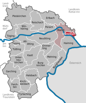
| Location of the municipality of Stammham in the district of Altötting | ||
  |
||

Stammham is a municipality in the Upper Bavarian district of Altötting and a member of the Marktl administrative community .
The parish village of Stammham is the place of the parish seat and is located in the valley of the Inn flowing south to the south . To the north are the Munich – Simbach railway line and the AÖ22 district road .


Community structure
Stammham has six districts:
history
Stammham was first mentioned in a document in 740 and was the seat of the mother parish of all surrounding villages for centuries. The parish church, dedicated to St. Lawrence, was built at the end of the 15th century. The parish (and school) district of Stammham also includes parts of the neighboring communities of Marktl, Julbach and Zeilarn with Lanhofen and the Maria Himmelfahrt branch church there . Stammham became an independent political municipality in the course of the administrative reforms in Bavaria in 1818.
Population development
Between 1988 and 2018, the community grew from 957 to 1,052 by 95 inhabitants or 9.9%.
politics
Municipal council
After the last local election on March 15, 2020 , the local council has twelve members. The turnout was 62.4% (2014: 74.3%). The choice brought the following result:
| Political party | Seats | Share of votes |
| CSU | 7th | 59.3% |
| Free voters | 5 | 40.7% |
Another member and chairman of the municipal council is the first mayor.
mayor
Franz Lehner (CSU) has been the first mayor since May 1, 1996. He was elected for another six years on March 15, 2020 with 90.0% of the vote.
coat of arms
The description of the coat of arms introduced in 1981 reads: “Split of blue and silver; in front a silver diagonal bar opposite one another, behind a red grid, covered with a blue bar. "
Architectural monuments
Soil monuments
Economy and Infrastructure
Established businesses
- Vh-Design.com, web design agency
- NDCom Digital GmbH & Co. KG, media and advertising agency
- Holz Reiterer, timber trade
- Auto Haunreiter, auto trade
- Likeadog dog school
traffic
The Munich – Simbach railway , which was opened on June 1, 1871 by the Royal Bavarian State Railways , runs through the municipality of Stammham . The Marktl train station is located along the route on the western boundary of Marktl . It is served every hour by regional trains of the Südostbayernbahn between Mühldorf and Simbach .
Stammham is on the federal highways B 12 and B 20 . This connects the community to the Burghausen motorway exit of the A 94 near Marktl.
Web links
- Entry on the coat of arms of Stammham (am Inn) in the database of the House of Bavarian History
- Stammham (am Inn): Official statistics of the LfStat
- Pfarrdorf Stammham in the local database of the Bavarian State Library Online . Bavarian State Library
Individual evidence
- ↑ "Data 2" sheet, Statistical Report A1200C 202041 Population of the municipalities, districts and administrative districts 1st quarter 2020 (population based on the 2011 census) ( help ).
- ^ Community Stammham in the local database of the Bavarian State Library Online . Bavarian State Library, accessed on December 23, 2017.
- ↑ Reinhard Wanka, Wolfgang Wiesner: The main line Munich-Simbach and its branch lines . Bufe-Fachbuch-Verlag, Egglham 1996, ISBN 3-922138-59-4 , p. 10 .
- ↑ Query of the course book route 941 at Deutsche Bahn. Retrieved March 23, 2020.

Altötting | Burghausen | Burgkirchen an der Alz | Emmerting | Erlbach | Feichten an der Alz | Garching an der Alz | Haiming | Halsbach | Kastl | Kirchweidach | Marktl | Mehring | Neuötting | Perach | Pleiskirchen | Reischach | Stammham | Teising | Töging am Inn | Tüßling | Tyrlaching | Untereukirchen | Winhöring