
Administrative community Marktl
| coat of arms | Germany map | |
|---|---|---|

|
Coordinates: 48 ° 15 ' N , 12 ° 51' E |
|
| Basic data | ||
| Existing period: | 1978– | |
| State : | Bavaria | |
| Administrative region : | Upper Bavaria | |
| County : | Altötting | |
| Area : | 33.52 km 2 | |
| Residents: | 3791 (Dec. 31, 2019) | |
| Population density : | 113 inhabitants per km 2 | |
| License plate : | AÖ, LF | |
| Association key : | 09 1 71 5103 | |
| Association structure: | 2 municipalities | |
| Association administration address : |
Marktplatz 1 84533 Marktl |
|
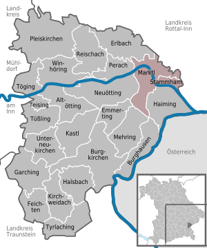
| Location of the Marktl administrative community in the Altötting district | ||
  |
||

The administrative community of Marktl in the Altötting district has existed since the municipal reform on May 1, 1978. Its member communities include:
The administrative association is based in Marktl.
Individual evidence
- ↑ "Data 2" sheet, Statistical Report A1200C 202041 Population of the municipalities, districts and administrative districts 1st quarter 2020 (population based on the 2011 census) ( help ).
Administrative communities in the Altötting district
Emmerting | Kirchweidach | Marktl | Reischach | Untereukirchen
Dissolved: Tüßling