Mehring (Upper Bavaria)
| coat of arms | Germany map | |
|---|---|---|

|
Coordinates: 48 ° 11 ' N , 12 ° 47' E |
|
| Basic data | ||
| State : | Bavaria | |
| Administrative region : | Upper Bavaria | |
| County : | Altötting | |
| Management Community : | Emmerting | |
| Height : | 432 m above sea level NHN | |
| Area : | 23.37 km 2 | |
| Residents: | 2459 (Dec. 31, 2019) | |
| Population density : | 105 inhabitants per km 2 | |
| Postal code : | 84561 | |
| Area code : | 08677 | |
| License plate : | AÖ, LF | |
| Community key : | 09 1 71 124 | |
| Community structure: | 14 districts | |
| Association administration address: | Lower Dorfstr. 3 84547 Emmerting |
|
| Website : | ||
| Mayor : | Robert Buchner ( FREE VOTERS ) | |
| Location of the municipality of Mehring in the Altötting district | ||
Mehring is a municipality in the Upper Bavarian district of Altötting and one of the two members of the Emmerting administrative community .
geography
Neighboring communities
Community structure
Mehring has 14 districts:
Mehring and Hintermehring represent the original core of the community. All other parts of the community were added through incorporation or dissolution of the community.
history
Pre-Christian times and antiquity
The origins of the place are in the dark, one can only speculate about the settlement in the time before the first documentary mention.
Since archaeological finds in the vicinity of Mehring (e.g. in Burgkirchen and Dorfen ) prove that the region was settled in pre-Christian times, it is reasonable to assume that Mehring was also settled itself. The location near the Alz river , the dense forest and the hill on which the village center of Mehring is located would have provided good prerequisites for establishing a settlement at that time. In the forest near Mehring, structures can be seen that suggest archaeological finds, although intensive research is still pending. However, it is conceivable that these structures are more recent and therefore do not provide any evidence of pre-Christian settlement. A general problem for artefacts from prehistoric times is centuries of agricultural use and settlement, so that potential historical sites of interest may be irreparably destroyed.
Late antiquity and early Middle Ages
The place name indicates a time when the place was created in the course of the Bavarian conquest in the 6th / 7th. Century: It is likely that the name "Moringen" (the ending -ing stands for a Germanic meeting place, see Thing ) goes back to a Romanic personal name ( Maurus or Morus).
Mehring was first mentioned in a document in 788 under the name "Moringen". At that time, the place was the seat of a knight family who called themselves after the community name "Moringer" or "Moeringer".
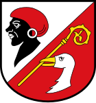
The origin of the name is controversial. The Mohrenkopf depicted on the municipal coat of arms indicates the origin of the name as a "Mohren". On the other hand, it is quite possible that the municipal coat of arms only reflects a symbolic representation of the name but not its origin, so the assumption is reasonable (see Mehring homeland book ) that Mehring can be traced back to the Romance personal name "Marus" or "More".
One speculation is that an Arab trader from North Africa could have settled at the site of today's community or that a group of people of southern origin might have ended up there in the course of pre-Christian migrations . According to recent research, the latter theory does not seem to be able to hold up. The trader theory appears to be more sound, with evidence from sources or archaeological research still lacking. The theory could be substantiated, however, by the fact that Arab traders actually had trade relations as far as Europe during this period. It is questionable whether these relationships extended to south-east Bavaria. Usually goods such as B. Substances are brought to the provinces on the other side of the Alps through middlemen, mainly traveling merchants.
Modern times
Until the beginning of the 19th century, Mehring was also the seat of the regional court external office, Ampt Mehring . The responsibilities included:
- Burgkirchen
- Branches
- Mehring
- Haiming
- Samarienberg (= Marienberg )
Mehring became a politically independent municipality in the course of the administrative reforms in Bavaria after Napoléon Bonaparte in 1818.
Incorporations
Since 1818 the political municipality Mehring has experienced several changes of area:
- On January 1, 1921, the Niederholz and Öd parishes were added to the dissolved Holzfeld parish .
- In 1969 the part of the municipality Hechenberg was reclassified into the city of Burghausen .
- In 1978 part of the Lindach community and part of the Badhöring community were also transferred to the town of Burghausen . Mehring has formed an administrative partnership with Emmerting since 1978 .
- In 2001, parts of the Holzfelder forest were incorporated into the municipality of Mehring.
Population development
Mehring has 2,473 inhabitants (as of December 31, 2016) The population has been growing steadily since the 1960s, especially in the Öd and Unghausen districts, as building land is designated here and the location near Burghausen is convenient for many commuters.
Between 1988 and 2018, the community grew from 1,872 to 2,505 by 633 inhabitants or 33.8%.
Church history
The parish of Mehring existed until 1399 and included Burghausen , around 1400 Mehring was subdivided into the parish of Raitenhaslach , then Burghausen. Mehring has only had an independent parish again since 1901. Mehring is thus one of the oldest parishes in the Diocese of Passau
The local church, which dates back to the 15th century, was built in 1445 and adapted in 1965 to meet the needs of a growing community, is dedicated to St. Martin of Tours .
politics
Municipal council
After the last local election on March 15, 2020 , the local council has 14 members. The turnout was 70.4% (2014: 61.7%). The choice brought the following result:
| CSU and independents | 6 seats | (43.4%) | |
| Free voters | 5 seats | (35.5%) | |
| SPD and environmentally conscious | 3 seats | (21.1%) |
Compared to the 2014 to 2020 term of office, the CSU / Independents and the SPD / Environmentally Conscious Party each lost one seat, the Free Voters gained two seats.
mayor
Another member and chairman of the municipal council is the mayor. Robert Buchner (Free Voters) was elected to this office on March 15, 2020 with 51.6% of the votes. His predecessor was Josef Wengbauer (CSU). He had been in office since May 2002 and was last confirmed in office in the 2014 local elections with 92.9% unopposed candidates.
coat of arms
The parish church is dedicated to St. Martin of Tours , whose insignia are the crosier and a goose, which is reflected in the coat of arms. The Mohrenkopf comes from the naming (see history), although it is unclear whether the name Mehring is actually derived from "Mohr" (see Heimatbuch Mehring ).
Even if the coat of arms is much older, as it was used in early documents, it was not until February 16, 1982, when the government of Upper Bavaria officially approved the use of the coat of arms and a flag.
economy
In the Hohenwart industrial area, thanks to the good transport links to the A94, several service and production companies have settled. This is also due to the proximity to Burghausen and the industrial companies there such as Wacker-Chemie AG and the OMV Deutschland GmbH refinery, as well as the Gendorf plant , formerly Hoechst AG .
traffic
Mehring has no rail connection and the Alz is not navigable. The state road runs directly between Mehring and Öd between Burghausen and Altötting , where it merges into the B12 or B20 and A94 .
Public facilities
Educational institutions
Mehring has both a primary school (Mehring) and a kindergarten (Öd). There are no secondary schools in the community. Middle school , secondary school and grammar school are located in the neighboring towns of Altötting and Burghausen
There is a day nursery in the primary school building.
Offices
Only the mayor's office is housed in Mehring itself (Scheibelbergstrasse 2), all other official institutions are in Emmerting, the seat of the administrative community Emmerting-Mehring.
Leisure and sports facilities
Mehring has a newly designed sports park with 3 soccer fields (2x large, 1x small), a DFB mini-field, a tennis facility with 3 clay courts, a stick shooting hall, and the sports hall newly built in 2009 (gym, gym, four bowling alleys and shooting range for game shooters) and the SV Mehring sports center.
In Hohenwart there is also the shooting range (long and short guns; 25/50/100 m) located on the Alz with the club's club. priv. fire rifle association Burghausen.
Culture and sights
theatre
Martin Lüttge's Theaterhof (former crime scene inspector ) is located in Priessenthal . Based on this, open-air performances take place regularly in summer.
Buildings
The church of Mehring, built in 1445, and the church of Hohenwart with an attached cemetery are historical buildings.
see also list of architectural monuments in Mehring (Upper Bavaria)
Geotopes
- Former Nagelfluh break in Unghausen; 2012 backfilling removed; Nagelfluh of the Günze Ice Age overlaid with coarse stones; geoscientific value "valuable"
Personalities
- Johann Bergmann (1887–1958), born in the district of Unghausen, a Roman Catholic priest, helped save many prisoners on a death train in 1945 .
- Martin Lüttge (1943–2017), actor and crime scene inspector, ran a theater courtyard in Mehring.
- Franz Werkstetter (born April 22, 1933) German politician and member of the state parliament
Individual evidence
- ↑ "Data 2" sheet, Statistical Report A1200C 202041 Population of the municipalities, districts and administrative districts 1st quarter 2020 (population based on the 2011 census) ( help ).
- ^ Mehring community in the local database of the Bavarian State Library Online . Bavarian State Library, accessed on September 9, 2017.
- ^ Wilhelm Volkert (ed.): Handbook of Bavarian offices, communities and courts 1799–1980 . CH Beck, Munich 1983, ISBN 3-406-09669-7 , p. 417 .
- ↑ https://www.freistaat.bayern/dokumente/behoerde/40774809640 .
- ↑ Geotope 171A006
Web links
- Entry on the coat of arms of Mehring (Upper Bavaria) in the database of the House of Bavarian History


