
Lechfall

The Lechfall is about twelve feet high, streaked entire width weir at Lech in the southern outskirts of feet .
description
The Lechfall is located on the southern edge of a short but deeply cut gorge , in which the Lech breaks through a rock that is assigned to the Falkensteinkamm to the west and the Ammergau Alps to the east . Whether this gorge (Latin : fauces : gorge, gorge, corridor) gave its name to Füssen is disputed. It was created at the end of the Würm Ice Age around 12,000 years ago, when the meltwater from the Lech Glacier formed a large lake that stretched as far as today's Pfronten . As a drainage from this lake, the Lech initially fell about 100 m deep over the rock ledge into what was then Lake Füssen and then eroded the narrow rock gorge.
Together with a drainage tunnel, the weir was built for the use of water power in the years 1784–1787. The construction project was also communicated at the time as the creation of a waterfall , more impressive than the former natural cataract . In the course of modernization of the hydropower plant, the remaining minimum water quantities for the Lechfall have now been established.
Despite its technical character, the overflowing weir has a noteworthy tourist attraction, especially since the waterfall clearly exceeds Germany's most abundant natural waterfall , the Alzfall near Altenmarkt , in terms of water flow and height.
The König-Max-Steg, which was built in 1895, leads over the waterfall, and a bust of King Maximilian II is located in a niche above the gorge .
According to legend, St. Magnus , fleeing from his pagan persecutors , jumped across the Lech at this point. The so-called Magnus step , a petrified shell, was interpreted in popular belief as its footprint.
Geotope
The Lechfall and Klamm near Füssen is designated by the Bavarian State Office for the Environment as geotope 777R016. The geotope is also one of the 100 most beautiful geotopes in Bavaria . See also the list of geotopes in the Ostallgäu district .
Picture gallery
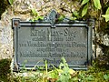
Sign for the König-Max-Steg
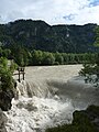
Lechfall after heavy rain

Gorge below the waterfall
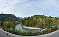
Lechfall and the surrounding area


See also
Web links
Individual evidence
- ↑ The name has been interpreted in two ways since the Middle Ages (see also the article Füssen ). The meaning of the name “Schlucht” can be found for example in: Werner Lengger: Füssen . In: Hans-Michael Körner , Alois Schmid with the assistance of Martin Ott (ed.): Bayern I. Altbayern und Schwaben (= manual of historical sites ). Alfred Kröner, Stuttgart 2006, ISBN 978-3-520-32401-6 , p. 253–255, here p. 254 . The monks of the St. Mang monastery used the spelling fauces in Latin manuscripts for feet . - Wolf-Armin von Reitzenstein , however, considers this to be an "obvious Latin reinterpretation": Wolf-Armin Freiherr von Reitzenstein: Lexicon of Bavarian place names. Origin and meaning . 2nd Edition. CH Beck, Munich 1991, ISBN 3-406-35330-4 , p. 148 . Since the city of Füssen lies "at the foot of the mountains", it received the talking coat of arms with the three feet around 1300 . - To this day, opinions differ. The tourism marketing of the city of Füssen draws the conclusion: "The origin of the name (is) not clear".
- ↑ Geotope: Lechfall and Klamm (accessed on March 22, 2020)
- ↑ Lechfall and Klamm (accessed on October 12, 2013)
Coordinates: 47 ° 33 ′ 41 ″ N , 10 ° 41 ′ 41 ″ E