
Trostberg
| coat of arms | Germany map | |
|---|---|---|

|
Coordinates: 48 ° 2 ' N , 12 ° 33' E |
|
| Basic data | ||
| State : | Bavaria | |
| Administrative region : | Upper Bavaria | |
| County : | Traunstein | |
| Height : | 493 m above sea level NHN | |
| Area : | 51.55 km 2 | |
| Residents: | 11,295 (Dec. 31, 2019) | |
| Population density : | 219 inhabitants per km 2 | |
| Postal code : | 83308 | |
| Area code : | 08621 | |
| License plate : | TS, LF | |
| Community key : | 09 1 89 157 | |
| City structure: | 94 districts | |
City administration address : |
Hauptstrasse 24 83308 Trostberg |
|
| Website : | ||
| Mayor : | Karl Schleid ( CSU ) | |
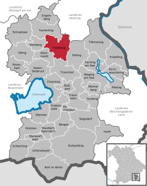
| Location of the city of Trostberg in the Traunstein district | ||
  |
||

Trostberg is a town in the Upper Bavarian district of Traunstein .
Geographical location
Trostberg is located in the planning region of southeast Upper Bavaria on the Alz at 502 m above sea level. [NHN], about 30 km north of the Chiemgau Alps. The city of Trostberg borders on the following neighboring communities: Tacherting , Kienberg , Altenmarkt an der Alz , Traunreut , Palling , Feichten an der Alz and Tyrlaching , the last two are already in the Altötting district .
history

Archaeological finds show that the history of the settlement dates back to the Stone, Bronze and Iron Ages. However, the first documentary evidence of the successful establishment of "Trospergs" by the Counts of Ortenburg-Kraiburg has only been available since 1233. The place developed under the protection of its early 13th century castle ( Trostberg Castle ). In 1301/7 the court (and the county) was named Trostberg in a ducal land register. Since then, Trostberg has always been owned by the Bavarian Wittelsbachers , the Alz was the border river between Bavaria and Salzburg. It was not so much the arable bourgeoisie, but rather trade and handicraft, and especially cloth making, that helped the city to prosper in the 17th and 18th centuries.
The district court of Trostberg , which comprised the northern part of today's district of Traunstein, was dissolved in 1799 and only restructured in 1803. The district courts of Kling and Trostberg were merged. In 1810 Trostberg lost its border location, until then Trostberg was closed in the west and east by towers and divided by the Mittertor between Hauptstrasse 1 and 2. In 1862 the district office (later district) Traunstein was founded, which administratively comprised the district court districts of Traunstein and Trostberg. In the early 20th century who spots Trostberg two Catholic churches, a sawmill , a Kunstmühle and was the seat of a district court .
In 1913 Trostberg was granted city rights. The towns of Heiligkreuz and Lindach, which belong to the city, belonged to the state of Salzburg until 1816 and are therefore part of the Rupertiwinkel .
Trostberg was also bombed during World War II, mainly because of its importance as an industrial location. From 1476, a medieval leprosy can be found in Trostberg , which was located between today's main road and the Au. The field name "Siechenanger" later indicated the Leprosorium.
Incorporations
On January 1, 1971, the previously independent community of Lindach was incorporated. On May 1, 1978 Heiligkreuz and Oberfeldkirchen were added.
Demographics
| year | population | Remarks |
|---|---|---|
| 1818 | 800 | counted in 131 houses in mid-1818 in the dean 's office in Peterskirchen |
| 1824 | 883 | in 136 residential buildings, with the castle district (18 residents in two residential buildings) |
| 1871 | 1252 | on December 1, 1871, of which 1240 Catholics, eight Evangelicals, four Jews (199 residential buildings) |
| 1905 | 1715 | Catholic residents |
| 1933 | 3252 | |
| 1939 | 3987 |
| year | 1840 | 1871 | 1900 | 1925 | 1939 | 1950 | 1961 | 1970 | 1987 | 1991 | 1995 | 2000 | 2005 | 2010 | 2011 | 2015 |
| Residents | 2,501 | 2969 | 3552 | 5054 | 5951 | 9321 | 9922 | 10.116 | 10,251 | 11,143 | 11,566 | 11,548 | 11,655 | 11,488 | 11,201 | 11,073 |
Between 1988 and 2018 the city grew from 10,361 to 11,222 by 861 inhabitants or 8.3%.
Community structure
There are 94 districts:
There are the following districts : Heiligkreuz, Lindach, Oberfeldkirchen and Trostberg.
politics
City council
The 24 seats of the Trostberg City Council were distributed among the parties and lists as follows in the local elections in Bavaria 2020 with a turnout of 52.96%:
| Party / list | CSU | SPD | Green | Free voters | total |
| Seats | 11 | 4th | 5 | 4th | 24 |
| Share of votes | 45.47% | 15.18% | 21.17% | 18.18% | 100% |
mayor
Mayor is Karl Schleid ( CSU ). In 2008 he succeeded Ignaz Sperger (CSU). In 2014 he was re-elected with 74.99% of the votes cast and on March 15, 2020 with two opposing candidates with 74.48% of the valid votes.
Finances
In 2012 the municipal tax revenue amounted to € 13,071 thousand, of which € 6,297 thousand was trade tax income (net).
Culture and sights

- Trostberg ensemble : The historic center is built in the Inn-Salzach style , the buildings often have typical wooden gable, balcony and arbor fronts on the Alz side. Worth seeing are u. a. Remains of the city wall made of unplastered tuff ashlar masonry, a neo-Gothic Marian column and a torture column made of red marble on Marienplatz.
- The older building structure of the Catholic parish church of St. Andrew (choir and northern side chapel) dates back to around 1420. The nave, a three-aisled hall with ribbed vaults, was built between 1498 and 1504. In 1869 a yoke was added to the west. The stained glass windows belong to the time towards the end of the 15th century, and grave monuments from the 15th and 16th centuries have been preserved.
- A new Catholic parish church was built in 1953 in the district of Schwarzau by Josef Wiedemann .
- The Protestant Christ Church, built in 1951 according to plans by the Trostberg architect Kurt Franck, was redesigned in 1988 by the architect Peter Schorr with the center of the church and the addition of community rooms.
- Remains of the former nursing home ( Trostberg Castle ) have been preserved on the Schlossberg .
- In the Heiligkreuz district, the Catholic Church Heilig Kreuz is worth mentioning, a late Gothic Nagelfluh block construction around 1434.
- The pigeon fountain in the historic city center was designed by the Munich sculptor Edmund Puchner in 1988 from Lower Bavarian granite.
See also: List of architectural monuments in Trostberg
Soil monuments
See: List of ground monuments in Trostberg
Economy and Infrastructure
economy
Trostberg, along with the Trostberg Chemical Park and its international chemical companies (formerly SKW Trostberg AG , today Alzchem AG , Degussa GmbH , BASF Construction Polymers GmbH and BASF Construction Chemicals GmbH), is one of the places that make up the Bavarian Chemical Triangle . Other important employers are the Rieger paper mill and EDEKA CHIEMGAU.
According to official statistics, there were twelve employees in the field of agriculture and forestry, 2404 in manufacturing and 809 in trade, transport and hospitality at the place of work. In other economic sectors, 1432 people were employed at the place of work subject to social security contributions. There were a total of 4019 employees at the place of residence subject to social security contributions. There were ten companies in the manufacturing sector and eleven in the construction sector. In 2007 there were 114 farms with an agriculturally used area of 3278 ha, of which 2641 ha were arable land and 612 ha were permanent green space.
traffic
- Street: By Trostberg leading national highway 299 , which in Altenmarkt in the national road 304 leads. Due to the heavy traffic from this road, a bypass for Trostberg has been planned for a long time.
- Rail: There is a connection on weekdays to the reactivated Traun-Alz-Bahn of the DB Regio / Südostbayernbahn .
- Aviation: Schönberg is located five kilometers to the north-west of Schönberg and is a special airfield approved for all types of aircraft up to 2000 kg maximum take-off weight (MTOW) .
-
Public Transport :
- various regional bus routes operated by Regionalverkehr Oberbayern GmbH
- a city bus route operated by Regionalverkehr Oberbayern GmbH
- Regional bus routes operated by the private operators Hövels OHG and Omnibus Wengler
Leisure and sports facilities
- (open) artificial ice stadium
- heated outdoor pool
- Football and athletics stadium (Jahnstadion)
Cultural institutions
- Postsaal cultural center
- Vault in the post room
- city Museum
- Atrium at the city museum
- Rose garden at Schedling Castle
- Hertzhaimer natural garden at the grammar school
schools
- Vocational school for nursing
- Heiligkreuz primary school
- Trostberg primary school
- Trostberg Middle School
- Hertzhaimer-Gymnasium Trostberg
- Trostberg Music School
- Rhema Bible Training Center Germany South
- State secondary school Trostberg
- Adult Education Center Trostberg e. V.
health
Trostberg has a district hospital that is part of the municipal clinic group Kliniken Südostbayern .
Personalities

The Pienzenauer
Hans von Pienzenau , ducal keeper in Trostberg from 1492 to 1499, defended the Kufstein fortress in the Landshut War of Succession in 1504 and is said to have shown the bare bottom before King Maximilian I's surrender . He was then beheaded. On the pedestal of his memorial on the Pienzenauer fountain it says: “Whoever is right shouldn't duck! Must be, hears it, then as now to the Kaisa and the authorities there! "
Honorary citizen
→ Main article: List of honorary citizens of Trostberg
sons and daughters of the town
- sorted according to chronology -
|
|
Personalities related to the city
- Karl Siegert (1811–1877), notary in Trostberg
- 1965, October 3rd, Markus Fröschl , member of the state parliament
literature
- Norbert Kühne : ACTION 73 in Trostberg / Obb. In: Norbert Kühne: We work with young people. Andreas Achenbach Verlag, Giessen 1975, pp. 71-82, ISBN 3-87958-126-6
- Rainer Lihotzky: Trostberg - The city on the Alz. Alois Erdl KG, Trostberg 2003, ISBN 3-925249-59-1
- Horst Biernath: Of course, it stays between us. Novel of a small town, Ehrenwirth Verlag, Munich 1974, ISBN 3-431-01527-1
Web links
- Entry on the coat of arms of Trostberg in the database of the House of Bavarian History
Individual evidence
- ↑ "Data 2" sheet, Statistical Report A1200C 202041 Population of the municipalities, districts and administrative districts 1st quarter 2020 (population based on the 2011 census) ( help ).
- ↑ a b c Meyer's Large Conversation Lexicon . 6th edition, Volume 19, Bibliographisches Institut, Leipzig and Vienna 1909, p. 751 ( Zeno.org ).
- ↑ see data from the Society for Leprosy in Bavaria, accessed October 22, 2016 ( Memento of the original from February 6, 2015 in the Internet Archive ) Info: The archive link was automatically inserted and not yet checked. Please check the original and archive link according to the instructions and then remove this notice.
- ^ Wilhelm Volkert (ed.): Handbook of Bavarian offices, communities and courts 1799–1980 . CH Beck, Munich 1983, ISBN 3-406-09669-7 , p. 582 .
- ^ Federal Statistical Office (ed.): Historical municipality directory for the Federal Republic of Germany. Name, border and key number changes in municipalities, counties and administrative districts from May 27, 1970 to December 31, 1982 . W. Kohlhammer GmbH, Stuttgart / Mainz 1983, ISBN 3-17-003263-1 , p. 593 .
- ↑ Martin von Deutinger : Tabular description of the Diocese of Freysing according to the order of the Decanate , Munich 1820, p. 455 ( online ),
- ↑ Deutinger, ibid., Vorerinnerung , p. VII
- ↑ Adolph von Schaden : Alphabetical directory of all the cities, markets, villages, hamlets, wastelands, etc. located in the Isar district (as an appendix to the topographical = statistical handbook for the Isar district of the Kingdom of Baiern, e-copy ), Munich 1825, p. 498 ( online ).
- ↑ Royal. Bavarian Statistical Bureau: Complete list of localities of the Kingdom of Bavaria - with an alpabetic general register containing the population according to the results of the census of December 1, 1875 , Munich 1877, column 329 ( online ).
- ↑ a b M. Rademacher: German administrative history from the unification of the empire in 1871 to reunification in 1990. City and district of Traunstein (online material for the dissertation, Osnabrück 2006)
- ↑ a b c Statistics municipal Trostberg
- ↑ Entry in the location database
- ↑ www.wahl.info: Trostberg
- ^ Joseph Plaß: Karl Siegert, Notary in Trostberg (Nekrolog), 1879 ( online )

Altenmarkt an der Alz | Mountains | Chieming | Engelsberg | Fridolfing | Grabenstätt | Grassau | Inzell | Kienberg | Kirchanschöring | Marquartstein | Nussdorf | Obing | Palling | Petting | Pittenhart | Reit im Winkl | Ruhpolding | Schleching | Schnaitsee | Seeon-Seebruck | Siegsdorf | Staudach-Egerndach | Surberg | Tacherting | Taching at the lake | Tittmoning | Traunreut | Traunstein | Trostberg | Overseas | Unterwössen | Vachendorf | Waging am See | Wonneberg
Unregulated areas: Chiemsee | Waginger See