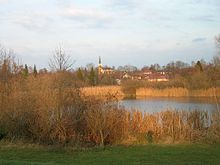
Chieming
| coat of arms | Germany map | |
|---|---|---|

|
Coordinates: 47 ° 54 ' N , 12 ° 32' E |
|
| Basic data | ||
| State : | Bavaria | |
| Administrative region : | Upper Bavaria | |
| County : | Traunstein | |
| Height : | 537 m above sea level NHN | |
| Area : | 37.74 km 2 | |
| Residents: | 4976 (Dec. 31, 2019) | |
| Population density : | 132 inhabitants per km 2 | |
| Postal code : | 83339 | |
| Area code : | 08664 | |
| License plate : | TS, LF | |
| Community key : | 09 1 89 114 | |
| LOCODE : | DE CMG | |
| Community structure: | 38 districts | |
| Address of the municipal administration: |
Hauptstrasse 20 83339 Chieming |
|
| Website : | ||
| First Mayor : | Stefan Reichelt ( CSU ) | |
| Location of the municipality of Chieming in the Traunstein district | ||
Chieming is a municipality in the Upper Bavarian district of Traunstein . It is located on the east bank of the Chiemsee on the Chieminger Bay and is a holiday and recreation area.
The namesake for Chieming as well as the Chiemsee and the entire Chiemgau is, according to legend, a Gaugraf " Chiemo ", whose existence, however, could never be proven.
geography
Chieming is located in the planning region of southeast Upper Bavaria in the Chiemgau . In the south of the village and in the district of Chieming lies the Pfeffersee , also called Pfaffersee.
history
Antiquity
The favorable location on the lake with arable land, forests and floodplains not far from salt deposits provided the basis for food that enabled Chieming to be settled as early as the Stone Age, although it remained thin until the construction of the Roman west-east traffic axis and military road Via Julia from Augsburg ( Augusta Vindelicorum ) to Salzburg ( Juvavum ). With this street the settlement with manors ( villae rusticae ), to supply the legion, is concentrated . The oldest graves that have been found so far date from the second half of the 6th century, at the time of the Bavarian conquest .
middle Ages
A first secure documentary evidence was found in 790 in the Notitia Arnonis . Chieming had been the parish seat since 1211 at the latest.
Notation

The spelling Kieming was in 1568 by Philipp Apian in Bairischen country panels used and can be found even in the 19th century in the Gazette No. 768 Frauenchiemsee and surroundings from the year 1847 of the Bavarian premiere as well as in the literature.
Formation of Bavaria
Constitutional
After the dissolution of the Electorate of Bavaria, an independent state emerged, which was elevated to a kingdom in 1806. In the course of the state reorganization in Bavaria, Chieming became a political municipality with the associated localities Aufham, Ausserlohen, Eglsee, Kleeham, Laimgrub, Pfaffing, Manholding, Schützing, Stöttham and Weidach. Egerer and Neubauer followed around 1850.
Canon law
The open Hofmark Chieming was owned by the Baumburg monastery until 1803 .
Economically and sociologically
Starting around 1870, Chieming became an increasingly popular bathing and recreation location.
Incorporations
In the course of the regional reform in Bavaria , the former communities Hart and Ising (officially renamed on October 30, 1965, previously Tabing ) were added on January 1, 1972. On January 1, 1982, the municipality of Grabenstätt gave an area with more than 50 inhabitants to the municipality of Chieming. These were parts of the former municipality of Oberhochstätt with its main town.
Outsourcing
On July 1, 1972, an area with around 60 inhabitants ( Graben district ) was ceded to the neighboring municipality of Seebruck .
Community structure
The 38 districts are:
There are the districts of Chieming, Hart, Ising and Oberhochstätt.
Population development
Between 1988 and 2018, the municipality grew from 3,793 to 4,936 by 1,143 inhabitants or 30.1%.
- 1961: 3045 inhabitants
- 1970: 3344 inhabitants
- 1987: 3685 inhabitants
- 1991: 4085 inhabitants
- 1995: 4189 inhabitants
- 2000: 4308 inhabitants
- 2005: 4475 inhabitants
- 2010: 4538 inhabitants
- 2015: 4827 inhabitants
politics
mayor
Stefan Reichelt (CSU) has been mayor since May 1, 2020; he was elected on March 29, 2020 in the runoff election with 54.43% of the vote. Its predecessors were
- Benno Graf (Independent Voters) from May 2002 to April 2020
- Maximilian Brunner (CSU) until April 2002
Municipal council
The municipal council election on March 15, 2020 resulted in the following distribution of seats:
- CSU : 6 seats (32.83%)
- Alliance 90 / The Greens : 5 seats (31.94%)
- Independent voters (UW) : 3 seats (20.65%)
- Bourgeois-rural voter group (BBW): 2 seats (14.58%)
coat of arms
Blazon: A black key and an overturned red sword crossed diagonally over a blue wave shield base in silver.
Attractions
- The parish church of the Assumption of Mary is a cross-vaulted hall building with a semicircular apse . It was built in 1882/83 and 1891 according to plans by the Munich architect Johann Marggraff in the neo-Romanesque style. Pastor Conrad Korntheur was the driving force behind the new building. When the old church was demolished, three Roman consecration stones came to light, which are now on the tower floor. The interior decoration and painting in the same style were designed by the architect Joseph Elsner and supplied from his Munich workshops. The altar painting was created by Max Fürst from Reichenhall around 1885 . The painting of Saints Sebastian and Georg on the south wall of the nave comes from a former side altar and is signed by Ruprecht Schweindl from Altenmarkt in 1663.
- The Beim Karl farm from 1875 in the district of Thauernhausen is a three-story Einfirsthof with a large bulk floor for the grain on the top floor.
Soil monuments
Economy and Infrastructure
Economy including agriculture and forestry
In 2017 there were 1,625 jobs subject to social security contributions in the municipality. Of the resident population, 1762 people were in an employment relationship subject to compulsory insurance. This meant that the number of out-commuters was 137 more than that of in-commuters. 68 residents were unemployed. In 2016 there were 63 farms.
traffic
Chieming is connected via the state road St 2096 and various other connecting roads with the state road St 2095 Rosenheim - Traunstein, which runs close to the site, and in a southerly direction with the A 8 Munich-Salzburg. Chieming has a landing stage for the Chiemsee-Schifffahrt , which, however, is not used out of season.
The closest train stations are Matzing on the Traun-Alz-Bahn (Traunstein-Garching railway) and Traunstein and Übersee on the Rosenheim – Salzburg railway .
Chieming has a connection to the RVO bus lines:
- 9520 Traunstein - Grabenstätt - Chieming - Seebruck - Prien am Chiemsee
- 9522 Traunstein - Nussdorf - Truchtlaching - Obing - Schnaitsee
- 9513 Chieming - Sondermoning - Traunreut
- N5 night express: Traunstein - Chieming - Seebruck - Seeon - Obing .
education
There are the following institutions (as of 2020):
- 3 kindergartens
- a primary and middle school
- Grammar schools: Landschulheim Schloss Ising with various training courses
Personalities
- Wolfgang Klausner (1906–1958), politician of the CSU, Member of the Bundestag
- Isabella Nadolny (1917-2004), writer
- Sten Nadolny (* 1942), writer, grew up in Chieming
- Norbert Niemann (* 1961), writer
Climate table
| Chieming | ||||||||||||||||||||||||||||||||||||||||||||||||
|---|---|---|---|---|---|---|---|---|---|---|---|---|---|---|---|---|---|---|---|---|---|---|---|---|---|---|---|---|---|---|---|---|---|---|---|---|---|---|---|---|---|---|---|---|---|---|---|---|
| Climate diagram | ||||||||||||||||||||||||||||||||||||||||||||||||
| ||||||||||||||||||||||||||||||||||||||||||||||||
|
Average monthly temperatures and rainfall for Chieming
Source: wetterkontor.de
|
|||||||||||||||||||||||||||||||||||||||||||||||||||||||||||||||||||||||||||||||||||||||||||||||||||||||||||||||||||||||||||||||||||||||
bibliography
- Dehio-Handbuch der Deutschen Kunstdenkmäler, Bavaria IV: Munich and Upper Bavaria, Darmstadt 1990
- Irmtraut HEITMEIER, place name interpretation and settlement history. A methodical attempt using the example of the south-eastern Chiemgau , in ZBLG 53 (1990), pp. 551-658
Web links
Individual evidence
- ↑ "Data 2" sheet, Statistical Report A1200C 202041 Population of the municipalities, districts and administrative districts 1st quarter 2020 (population based on the 2011 census) ( help ).
- ↑ The Mayor. Chieming municipality, accessed on June 5, 2020 .
- ^ Karl Puchner, Romano-Germanic mixed names in Old Bavaria. (From the names of Central Europe, FS f. E. Kranzmayer, Kärnter Museumsschriften 53) Klagenfurt 1972, 61–67; Karl Puchner assigns the name to the German or mhd. Root Ki / Kime "Sprößling"
- ↑ Helmut Rosenfeld, Chiemsee and Chieming (BONF 18) 1981, 23-26; Helmut Rosenfeld assigns the name to the Celtic cultural area or the Celtic first name “Chiemo” to “clan”.
- ↑ See https://www.chieming.de/chiemings-historie-1
-
↑ see Irmtraut HEITMEIER, Place Name Interpretation and Settlement History . A methodical attempt using the example of the southeastern Chiemgau , in ZBLG 53 (1990), pp. 551-658, page 575
- ^ Original position sheet No. 768 of the land survey in Bavaria
- ↑ Bayerische Annalen, Jhrg. I, 1833, p. 224
- ^ Wilhelm Volkert (ed.): Handbook of Bavarian offices, communities and courts 1799–1980 . CH Beck, Munich 1983, ISBN 3-406-09669-7 , p. 581 .
- ^ Federal Statistical Office (ed.): Historical municipality directory for the Federal Republic of Germany. Name, border and key number changes in municipalities, counties and administrative districts from May 27, 1970 to December 31, 1982 . W. Kohlhammer, Stuttgart / Mainz 1983, ISBN 3-17-003263-1 , p. 814 .
- ^ Federal Statistical Office (ed.): Historical municipality directory for the Federal Republic of Germany. Name, border and key number changes in municipalities, counties and administrative districts from May 27, 1970 to December 31, 1982 . W. Kohlhammer, Stuttgart / Mainz 1983, ISBN 3-17-003263-1 , p. 592 .
- ↑ http://www.bayerische-landesbibliothek-online.de/orte/ortssuche_action.html ? Anzeige=voll&modus=automat&tempus=+20111108/173824&attr=OBJ&val= 551
- ^ Entry on the coat of arms of Chieming in the database of the House of Bavarian History
- ↑ Sepp Linner in Chiemgau-Blätter, supplement to Traunsteiner Tagblatt No. 12, March 26, 2011, pp. 1–3


