
Kirchanschöring
| coat of arms | Germany map | |
|---|---|---|

|
Coordinates: 47 ° 57 ' N , 12 ° 50' E |
|
| Basic data | ||
| State : | Bavaria | |
| Administrative region : | Upper Bavaria | |
| County : | Traunstein | |
| Height : | 417 m above sea level NHN | |
| Area : | 25.23 km 2 | |
| Residents: | 3329 (Dec. 31, 2019) | |
| Population density : | 132 inhabitants per km 2 | |
| Postcodes : | 83417, 83329 | |
| Area code : | 08685 | |
| License plate : | TS, LF | |
| Community key : | 09 1 89 127 | |
| Community structure: | 49 districts | |
| Address of the municipal administration: |
Rathausplatz 2 83417 Kirchanschöring |
|
| Website : | ||
| Mayor : | Hans-Jörg Birner ( CSU ) | |
| Location of the municipality of Kirchanschöring in the Traunstein district | ||
  |
||


Kirchanschöring is a municipality in the Upper Bavarian district of Traunstein . It is located in Rupertiwinkel and borders with the districts of Wolkersdorf and Lampoding on the east bank of Lake Waginger , while the village of Kirchanschöring itself is a few kilometers away.
Alongside Tittmoning , Fridolfing and Taching am See , Kirchanschöring is part of the intermunicipal cooperation Salzachtal , one of 21 nationwide model regions that were selected as part of the competition for the regional services of general interest of the Federal Ministry for Transport, Building and Urban Development (BMBVS) .
Community structure
Kirchanschöring has 49 districts:
|
history
Until the church is planted
Kirchanschöring was first mentioned in the Breves Notitiae in 798/800 as "Ansheringen". The entry in the Salzburg Archbishop's register of goods deals with gifts of goods to the church. Today the place is still called "Anschering" in the dialect. The name probably goes back to the name Ansheri or Anskar, which means that the place was named after a man who was called that and who settled here with his people. The ending "ing" indicates the place as a Bavarian foundation. Over the centuries this became Anschering and then, when a church was built in the 14th century, it became Kirchanschöring.
The Salzburger Land was initially part of the Duchy of Bavaria. In 1275 the Duke largely recognized the holdings of the Archbishop of Salzburg and in the second Treaty of Erharting confirmed the western border of the Archbishop's territory. With the enactment of its own Salzburg state order, Salzburg broke away from Bavaria in 1328 and became an independent state within the Holy Roman Empire.
The first school in Kirchanschöring was mentioned as early as 1685.
In 1806 Salzburg fell to Austria and in 1810 to Bavaria. When Salzburg was annexed to Austria for the second time in 1816, the area west of Saalach and Salzach, in which Kirchanschöring is located, was separated. This area remained with Bavaria and was later called Rupertiwinkel. Since 1818 the place is an independent municipality; around 800 people lived there in 175 houses.

20th and 21st centuries
On July 1, 1972, Kirchanschöring was reclassified from the dissolved district of Laufen to the district of Traunstein. In 2005, Kirchanschöring received the gold medal in the federal decision Our village should become more beautiful, our village has the future .
Incorporations
On January 1, 1972, the previously independent municipality of Lampoding was incorporated.
Population development
Between 1988 and 2018 the municipality grew from 2,602 to 3,365 by 763 inhabitants or by 29.3%.
politics
mayor
Hans-Jörg Birner (CSU) has been mayor since May 1, 2008; he was confirmed in office for a further six years on March 15, 2020 with 89.12% of the vote.
Municipal council
In the local elections on March 15, 2020 , the composition of the local council was as follows:
- CSU : 6 seats (35.30%)
- Free voter community : 5 seats (29.22%)
- Alliance 90 / The Greens : 3 seats (20.60%)
- SPD : 2 seats (14.88%).
coat of arms
The description of the municipal coat of arms introduced in 1975 reads: "In blue over a lowered silver rose, a silver bowl scale."
economy
The international companies Meindl (shoes, traditional costume and leather clothing) and Royalbeach Spiel- und Sportartikel Vertriebs GmbH (fitness and outdoor items as well as inflatable products) have their headquarters here. In addition, tourism, commercial operations and agriculture are other pillars.
traffic
The Kirchanschöring stop is on the Mühldorf – Freilassing railway line .
Attractions
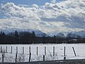
View of Kirchanschöring and the Alps in winter

... and in summer

A settlement in Kirchanschöring


- Late Gothic Catholic Church of St. Giles in Kirchstein with a 27 m high onion dome , a branch of the parish of Petting
- Farm museum in Hof
- Chapel of St. Koloman near Lebenau
- Late Gothic chapel in Reichersdorf (formerly the rectory of the Petting parish )
See also: List of architectural monuments in Kirchanschöring
Soil monuments
See: List of ground monuments in Kirchanschöring
Club life
There are a variety of local associations such as the volunteer fire brigade , fruit and horticultural association , stopper club , theater association and water watch .
SV Kirchanschöring is known nationwide and has played in the fifth -rate Bayern League South since 2015 . In the 1976/77 season they played in the then fourth -rate Bavarian regional soccer league .
sons and daughters of the town
- Bernd Dürnberger (* 1953), soccer player
Web links
- Official website
- Entry on the coat of arms of Kirchanschöring in the database of the House of Bavarian History
Individual evidence
- ↑ "Data 2" sheet, Statistical Report A1200C 202041 Population of the municipalities, districts and administrative districts 1st quarter 2020 (population based on the 2011 census) ( help ).
- ↑ Action program for regional services of general interest - Intercommunal cooperation Salzachtal. ( Memento from September 9, 2012 in the web archive archive.today )
- ↑ Kirchanschöring parish. ( Memento from September 3, 2012 in the web archive archive.today )
- ↑ bayerische-landesbibliothek-online.de
- ^ Wilhelm Störmer: Nobility groups in early and high medieval Bavaria. Commission for Bavarian State History, Munich 1972, ISBN 3-7696-9877-7 , p. 66f: The illustres in Kirchanschöring.
- ^ Wilhelm Volkert (ed.): Handbook of Bavarian offices, communities and courts 1799–1980 . CH Beck, Munich 1983, ISBN 3-406-09669-7 , p. 510 .
- ↑ kirchanschoering.info

Altenmarkt an der Alz | Mountains | Chieming | Engelsberg | Fridolfing | Grabenstätt | Grassau | Inzell | Kienberg | Kirchanschöring | Marquartstein | Nussdorf | Obing | Palling | Petting | Pittenhart | Reit im Winkl | Ruhpolding | Schleching | Schnaitsee | Seeon-Seebruck | Siegsdorf | Staudach-Egerndach | Surberg | Tacherting | Taching at the lake | Tittmoning | Traunreut | Traunstein | Trostberg | Overseas | Unterwössen | Vachendorf | Waging am See | Wonneberg
Unregulated areas: Chiemsee | Waginger See