
Saaldorf-Surheim
| coat of arms | Germany map | |
|---|---|---|

|
Coordinates: 47 ° 52 ' N , 12 ° 56' E |
|
| Basic data | ||
| State : | Bavaria | |
| Administrative region : | Upper Bavaria | |
| County : | Berchtesgadener Land | |
| Height : | 438 m above sea level NHN | |
| Area : | 39.1 km 2 | |
| Residents: | 5519 (Dec 31, 2019) | |
| Population density : | 141 inhabitants per km 2 | |
| Postal code : | 83416 | |
| Primaries : | 08654, 08682, 08666 | |
| License plate : | BGL, BGD, LF , REI | |
| Community key : | 09 1 72 130 | |
| Address of the municipal administration: |
Moosweg 2 83416 Saaldorf-Surheim |
|
| Website : | ||
| Mayor : | Andreas Buchwinkler (Young List) | |
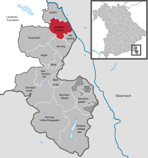
| Location of the community Saaldorf-Surheim in the district of Berchtesgadener Land | ||
  |
||

Saaldorf-Surheim is a municipality in the Upper Bavarian district of Berchtesgadener Land . It is located north of Freilassing and borders on Austria on the eastern side.
geography
The municipality belongs to the Bavarian Rupertiwinkel . It is located in the Salzach hill country and borders the following communities: Freilassing and Ainring in the south, Teisendorf and Petting in the west and Laufen in the north. A river, the Sur, flows through Surheim. The eastern border of the municipality forms the Salzach, which is also the border with Austria. In the Abtsdorf district there is the Abtsdorfer See nature reserve on the lake of the same name , which also includes the Haarmoos wetland , which is a moor. The street of the residences runs through Surheim, which is located on the Sur .
history
Saaldorf and Surheim were first mentioned in a document in 788 in the Notitia Arnonis . For a long time Saaldorf was the seat of a chairmanship of the Archbishopric of Salzburg and fell to the Principality of Salzburg of Archduke Ferdinand of Tuscany during the secularization of 1803 with Surheim . In 1805 the area came to Austria in the Peace of Pressburg , which it had to cede to Bavaria in 1809/10. The community area was formed in 1818 after the separation from Salzburg from seven former court districts of the Oberlebenau and Staufeneck nursing courts . The previously independent communities Saaldorf and Surheim were merged on May 1, 1978 to form a new community called Saaldorf. Since May 1st 1994 the community name is Saaldorf-Surheim.
Population development
Between 1988 and 2018 the municipality grew from 4,201 to 5,525 by 1,324 inhabitants or 31.5% - the highest percentage increase in the district in the period mentioned.
Religions
For centuries, the municipality belonged to the Roman Catholic parish of Salzburghofen . It was not until 1891 that Saaldorf and 1957 Surheim became their own parish.
politics
Municipal council
Since the municipal council election on March 15, 2020 , the Saaldorf-Surheim council has been composed as follows:
| Party / list | Seats |
| Christian Social Union in Bavaria (CSU) | 6th |
| Social Democratic Party of Germany (SPD) | 1 |
| Alliance 90 / The Greens (Greens) | 3 |
| Free non-partisan voters Saaldorf-Surheim (FÜW) | 4th |
| Young List Saaldorf-Surheim (JL) | 6th |
The turnout was 69.1%.
mayor
Andreas Buchwinkler (Young List) has been mayor since May 1, 2020; he was elected on March 15, 2020 with 73.76% of the vote. His predecessor from May 2014 to April 2020 was Bernhard Kern (CSU), who was no longer a candidate.
coat of arms
The description of the coat of arms reads: In a wave cut divided by silver and red, above a blue wheel, which is decorated with a growing blue heraldic lily on the right and left, below a horizontal silver door hinge, covered by a golden spike. The flag shows three stripes in the color sequence red-white-blue with the applied coat of arms.
Community partnerships
The partner municipality of Saaldorf-Surheim has been the village of Kővágóörs in Hungary since September 29, 2007 .
Culture and sights
Cultural traditions
A cultural peculiarity is the custom of the `` Aperschlizens '' . Saaldorf is the seat of the Schnalzervereinigung Rupertiwinkel , which was founded here in 1957. The Aperschnalzen is only in the Bavarian Rupertiwinkel and neighboring Salzburger Flachgau exercised.
Buildings

- The parish church of St. Martin in Saaldorf was built in 1914–1915 in the neo- baroque style according to plans by the Munich architects Joseph Elsner senior and / or Joseph Elsner junior . The altars from the previous church were changed to the neo-baroque style and adapted to the spatial conditions. For cost reasons, the interior height had to be reduced by three meters, contrary to the original plan.
- The parish church of St. Stephanus in Surheim was extended by one yoke in 1914 and redesigned in the neo-baroque style.
- In 1273 the church of St. Johann Baptist was built on a former castle hill ( Burgstall Steinbrünning ) .
economy
The import drug company EurimPharm Arzneimittel is based in the municipality. The Porr GmbH & Co KGaA and civil engineering has settled in the town of their Germany-Gesellschaft.
Sons and daughters of the church
- Anton Streitwieser (1916–1972), SS leader and protective custody camp leader in Mauthausen concentration camp
- Günter Hager (1943–2017), German legal scholar
- Anton Kern (* 1951), former member of the state parliament D. (CSU)
literature
- Dehio , Bayern IV: Oberbayern , pp. 1045 and 1144
- Christian Art in Bavaria, No. 16: The churches of the parish Saaldorf . Salzburg 2006
Web links
- Community homepage
- Entry on the coat of arms of Saaldorf-Surheim in the database of the House of Bavarian History
Individual evidence
- ↑ "Data 2" sheet, Statistical Report A1200C 202041 Population of the municipalities, districts and administrative districts 1st quarter 2020 (population based on the 2011 census) ( help ).
- ^ Federal Statistical Office (ed.): Historical municipality directory for the Federal Republic of Germany. Name, border and key number changes in municipalities, counties and administrative districts from May 27, 1970 to December 31, 1982 . W. Kohlhammer GmbH, Stuttgart / Mainz 1983, ISBN 3-17-003263-1 , p. 597 .
- ↑ StBA: Changes in the municipalities in Germany, see 1994
- ↑ Attribution not confirmed.

Ainring | Anger | Bad Reichenhall | Bayerisch Gmain | Berchtesgaden | Bischofswiesen | Freilassing | Running | Marktschellenberg | Piding | Ramsau near Berchtesgaden | Saaldorf-Surheim | Schneizlreuth | Schönau am Koenigssee | Teisendorf
Unparished areas:
Eck |
Schellenberger Forest