
Eck (unincorporated area)
| coat of arms | Germany map | |
|---|---|---|

|
Coordinates: 47 ° 37 ' N , 13 ° 5' E |
|
| Basic data | ||
| State : | Bavaria | |
| Administrative region : | Upper Bavaria | |
| County : | Berchtesgadener Land | |
| Height : | 1421 m above sea level NHN | |
| Area : | 12.6 km 2 | |
| Residents: | 0 (Dec. 31, 2019) | |
| Population density : | 0 inhabitants per km 2 | |
| License plate : | BGL, BGD, LF , REI | |
| Community key : | 09 1 72 452 | |
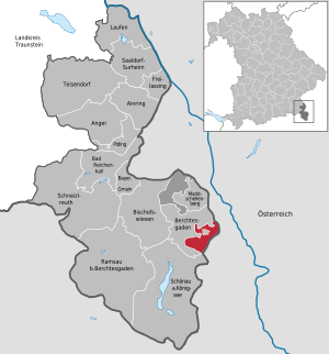
| Location of the community-free area Staatsforst Eck in the Berchtesgadener Land district | ||
  |
||


The state forest corner is after the Schellenberger forest the smaller of the two remaining municipality-free areas in the district Berchtesgadener Land , with an area of 12.60 km².
In the area there are the Ecker Alm , the Untere and the Obere Ahornalm and the Roßfeldalm , all of which are bumped . The Roßfeldhütte in the immediate vicinity of the Roßfeldalm, on the other hand, belongs with its surroundings as an exclave to the Berchtesgaden market , as well as the Berggasthof Ahornkaser (restaurant and apartment in the area of the Upper Ahornalm), as well as three other exclaves ( Purtschellerhaus , Schifferer Hütte and Berlerkaser car park opposite). The Ecker Alm and the Obere and Untere Ahornalm have architectural monuments . Of the abandoned Ofneralm , only the Kaser from 1871 remains, which is used by the forestry office as a service hut.
Within the national forest is a 100- hectare large enclave of market Berchtesgaden with part of Gnotschaft residues ( district Au ) and the settlement Buchenhöhe (district Salzberg ). There are also five Berchtesgaden enclaves (see above), which together with the parcel around the Kehlsteinhaus form the Eck district within the Berchtesgaden market.
The federal road 319 leads through the area and the Roßfeldhöhenringstraße branches off from it . In addition, the Kehlsteinstrasse leads through the area, but the Kehlsteinhaus is no longer in the municipality-free area, but in the municipality of Markt Berchtesgaden .
Land use
The forest takes up almost 72 percent of the area, followed by rocks (which, according to the official land categorization, belonged to the unland ) with 16 percent. In addition, the agricultural area category is worth mentioning with 8.5 percent.
|
|
Individual evidence
- ↑ "Data 2" sheet, Statistical Report A1200C 202041 Population of the municipalities, districts and administrative districts 1st quarter 2020 (population based on the 2011 census) ( help ).
- ↑ Bavarian State Office for Monument Preservation: Eck (PDF file; 63 kB)
- ↑ Usage type key according to the AdV usage type directory from 1991 ( memento of the original dated December 1, 2017 in the Internet Archive ) Info: The archive link was inserted automatically and not yet checked. Please check the original and archive link according to the instructions and then remove this notice.
- ↑ Type of use key according to ALKIS
Web links
- Expansion of the community-free area in OpenStreetMap (accessed on November 17, 2017)

Ainring | Anger | Bad Reichenhall | Bayerisch Gmain | Berchtesgaden | Bischofswiesen | Freilassing | Running | Marktschellenberg | Piding | Ramsau near Berchtesgaden | Saaldorf-Surheim | Schneizlreuth | Schönau am Koenigssee | Teisendorf
Unparished areas:
Eck |
Schellenberger Forest