Piding
| coat of arms | Germany map | |
|---|---|---|

|
Coordinates: 47 ° 46 ' N , 12 ° 55' E |
|
| Basic data | ||
| State : | Bavaria | |
| Administrative region : | Upper Bavaria | |
| County : | Berchtesgadener Land | |
| Height : | 455 m above sea level NHN | |
| Area : | 17.67 km 2 | |
| Residents: | 5444 (Dec. 31, 2019) | |
| Population density : | 308 inhabitants per km 2 | |
| Postal code : | 83451 | |
| Primaries : | 08651, 08656, 08654 | |
| License plate : | BGL, BGD, LF , REI | |
| Community key : | 09 1 72 128 | |
| LOCODE : | DE PID | |
| Address of the municipal administration: |
Thomastraße 2 83451 Piding |
|
| Website : | ||
| Mayor : | Hannes Holzner ( CSU ) | |
| Location of the municipality of Piding in the Berchtesgadener Land district | ||
Piding is a municipality in the Upper Bavarian district of Berchtesgadener Land with a little over 5000 inhabitants. The place is also a state-recognized health resort and connects directly to the north of Bad Reichenhall . Piding is in the Rupertiwinkel .
geography
Geographical location
Piding is located in the middle of the Berchtesgadener Land district and is also the southernmost municipality in the Rupertiwinkel , which was part of the Salzburg archbishopric for around 500 years .
The municipality is a natural unit: in the south the area is bounded by Hochstaufen (1771 m) and Fuderheuberg (1350 m), in the east by the Saalach and in the north-west by the 827 m high Högl . In the northeast, the Saalach forms the border with the State of Salzburg.
At Piding, the Stoißer Ache joins the Saalach north of the autobahn .
Parts of the municipality and neighboring municipalities
The districts are the parish village of Piding, the church village of Mauthausen , the villages of Kleinhögl , Pidingerau , Staufenbrücke and Urwies and the hamlet of Bichlbruck . Neighboring communities are the city of Bad Reichenhall, the communities Ainring , Anger , Inzell (Lkr. Traunstein) and Wals-Siezenheim (on the Austrian side).
history
prehistory
No traces of the hunter-gatherer cultures in the area have yet been discovered within the local boundaries. The Neolithization , i.e. the immigration of rural populations from the Middle East and the Balkans, began in Central Europe in the middle of the 6th millennium BC. A. The expansion of the associated linear ceramic culture took place in a relatively short time, perhaps a century, to the Rhine . First pioneer settlements arose around 5500 BC. BC, for example in Pfettrach , Schwanfeld , Straubing - Lerchenhaid or Stephansposching - the latter were surrounded by a wall and very long-lived, while smaller settlements, perhaps depending on them, were rather short-lived. There was extensive long-distance trade across the Danube to the Mediterranean, for example with spondylus shells .
Around 1960 four copper bars from the early Bronze Age were found approx. 250 m from the Schwaig property in the area of the northeast slope sloping down to the Nesselbachgraben . A marginal ridge ax was discovered in 1997 at the most 20 m from the site . This finding is part of an accumulation of 31 copper deposits in Upper Bavaria, which is related to the exploitation of the Eastern Alpine copper deposits. Also in 1997 a copper ring bar depot was recovered, which consisted of 60 bars. Some of the bark has been wrapped around it.
Celts and Romans
In Celtic time in the area of stem was Alauni resident who the Noricum belonged. They maintained trade contacts in the direction of the Mediterranean region, which began around 150 BC. BC was operated with its own coins (oboles), as a corresponding find on the Mallnitz Tauern proved.
Traces of Roman settlement on the Sale near Piding were already known in the early 19th century. The area belonged to the Roman Empire from around AD 15 to 488 and was located in the province of Noricum Ripense in the district of the city of Iuvavum (Salzburg). As a result, the area around Piding was integrated into a vast economic area for the first time. In addition to the transalpine routes, the so-called Via Julia was added as the main economic (and military) connecting road to Gaul in the west and to Constantinople . With the elevation of Iuvavum, today's Salzburg, to the municipium Claudium Iuvavum, it became the first urban settlement with the right to self-government north of the Alps. Its area included the Chiemgau, the Rupertiwinkel and the Inn area in the west. The destruction by Marcomanni in the year 171 led to a demographic decline that Diocletian was only able to compensate to a limited extent. In 488 a large part of the Romansh population was evacuated from Noricum ripense by order of Odoacer . When the Heimatmuseum Reichenhall was founded for the first time in 1854 and its holdings were to be increased with artefacts from the property of the population, a "two-handled, five-shoe long Roman sword" and a "Roman tool peculiar to its shape and composition" came to light.
Lombards, Bavarians, Christianization, first mention
Around 540 Lombards settled near Waging am See in the Rupertiwinkel. From the 6th century onwards, the area, and thus Piding, was part of the Salzburggau in the tribal duchy of Baiern , to which Bavarian row graves discovered in Mauthausen in 1965 bear witness.
Missionary work in the Duchy of Bavaria began at the end of the 7th century, and Duke Theodo (probably Theodo II (* before 665; † October 15 around 717)) handed over around 700 (probably already 696) a. a. the village as a gift to Bishop Rupert von Salzburg (around 650–718), presumably also so that he could dispose of the salt trade on water and on land. This transfer is recorded in the Notitia Arnonis . This is where piding is mentioned for the first time. At the same time, Piding is shown as the first place in the area of today's Rupertiwinkel in which the Salzburg diocese owned goods.
The place name was around 700 Pidinga , 790 Pidingen and from 1294 Piding . The Bavarian affiliation suffix -ing indicates a development during the time of the Bavarian conquest. The personal name Pido can be deduced from the place name , so that a leader of this name probably settled there. Thus the place name means something like "with the people of Pido".
The community takes the year 735 as the year of foundation and accordingly celebrated its 1250th anniversary in 1985. This year the donations from the Bavarian Duke Theodo to the Bishop of Salzburg are made.
Legal relationships, predominance of the Prince Archbishopric of Salzburg

After the Counts of Plain died out around 1260, the county in the upper Salzburggau, to which Piding also belonged, fell to the Archbishop of Salzburg , whose limits of his property were largely recognized by the Bavarian Duke in 1275.
The Bavarian Salbuch from around 1280 lists three courtyards belonging to “Pidinge” with slopes to the ducal office of Neuburg, more precisely to the Martini Chapel. Two of the goods there received Niederönenfeld Monastery from Ludwig the Bavarian and his son Duke Stephan on March 21, 1344. In the division of 1310, Piding was assigned to the Ingolstadt part . Piding seems to have been handed over to the neighboring Ortelfing for pastoral care. This link was not broken until 1683.
In 1305/1306 the Archbishop of Salzburg acquired the Staufeneck Castle , which was owned by the Staufeneck ministerial family in the 12th and 13th centuries. Century at the foot of the Hochstaufen was built. It later became the seat of a nursing court . Under his successor Friedrich III. von Leibnitz († March 30, 1338) the area became part of the Prince Archbishopric of Salzburg , which was now detached from Bavaria and was largely independent within the empire, including its own regional system .
Until the beginning of the 20th century, the reddish-gray, flat to thick-banked Högler sandstone , which was quarried on the eponymous mountain and which is partially located in the municipality of Piding, was an essential industry. The sandstone was used for door and window frames, but also served as a grindstone. In particular for the royal seat of Salzburg, Piding thus supplied considerable amounts of building material; in the 18th and 19th centuries, it also shaped the Rupertiwinkel in secular construction.
Reformation and Counter-Reformation, secularization, transition to Bavaria (1810)
During the Reformation , the aries of both parties were confiscated and given back on the basis of a long lease system. Through the Neuburg dissolutio massae , the pastor regained the claims to all tithe income from Ortelfing and Piding. The property on Ortelfing remained in lay hands and passed the gilt on to the pastor. In contrast, the estate on Piding was completely bought back to the parish in 1685.
In the course of the secularization imposed by Napoleon and in particular with the dissolution of the ecclesiastical domains, the last Archbishop of Salzburg abdicated in 1803. The secularization of Bavaria brought Piding 1810 just like the rest, since then as " Rupertiwinkel called" territory to the Kingdom of Bavaria , while the rest of Salzburg in Austria came. Piding belonged to 1818 for district court Teisendorf and subsequently to the district court Reichenhall associated with that from 1862 in the district office Berchtesgaden and from 1939 in the district Berchtesgaden passed.
World War II and post-war period
After the end of the Second World War , over 2 million refugees and displaced persons from Eastern and Southeastern European countries were registered in the Piding transit camp and distributed all over the Federal Republic of Germany. Many found their second home in Piding, which increased the population from 1,140 (1939) to 1,540 (1946). There were two camps: The Piding camp existed from September 1945 to July 1, 1962 , and from May 1, 1948 was called the Piding border transit camp . Right next to it is the residential camp, which was predominantly occupied by Sudeten Germans and from which the industrial settlement of Piding and today's residential area developed. The transit camp was again in the public eye in 1956 in the course of the Hungarian uprising when it took in over 5,000 refugees from Hungary. The district is still popularly called "camp" today.
In the past, Piding was almost exclusively characterized by agriculture, but its importance declined sharply from the middle of the 20th century. The most important company in the industrial settlement in Piding was the Hans Schowanek company , which manufactured wooden goods in Piding until 1958 (including a production and sales license for the Scrabble letter laying game ) and exported them worldwide (1955: approx. 400 employees).
Since the territorial reform
Until June 30, 1972, Piding belonged to the Berchtesgaden district , which was merged with the southern part of the Laufen district and the independent city of Bad Reichenhall to form the new Bad Reichenhall district as part of the Bavarian regional reform on July 1, 1972 . On May 1, 1973, the district was given its current name Landkreis Berchtesgadener Land .
In 1978, the district of Bichlbruck , which had previously belonged to the municipality of Ainring, and the district of Kleinhögl, which had been part of the dissolved municipality of Högl, were amalgamated or incorporated into Piding .
In 1985 the 1250th anniversary of Piding was celebrated. The basis for calculating this jubilee with 735 as the starting year were the donations made by the Bavarian Duke Theodo to the Bishop of Salzburg.
In 1997 the EuRegio Salzburg - Berchtesgadener Land - Traunstein was founded for the purpose of cultural and economic cooperation , to which Piding also belongs.
Population development
Between 1988 and 2018 the municipality grew from 4,270 to 5,419 by 1,149 inhabitants or by 26.9%.
| Population development in Piding | ||||
|---|---|---|---|---|
| from 1840 to 2015 | ||||
| year | Residents | year | Residents | |
| 1840 1) | 586 | 1970 1) | 3283 | |
| 1871 1) | 578 | 1987 1) | 4213 | |
| 1900 1) | 822 | 1991 1) | 4517 | |
| 1925 1) | 930 | 1995 1) | 4917 | |
| 1939 1) | 1181 | 2005 1) | 5363 | |
| 1950 1) | 2560 | 2010 1) | 5244 | |
| 1961 1) | 2977 | 2015 1) | 5384 | |
| 1) Figures: Bayer. State Office f. Statistics and Data processing | ||||
religion
According to the figures from the census on May 9, 2011, 63.3 percent of the parish population in the community of Piding belonged to the Roman Catholic Church (parish of Mary's birth) and 12.7 percent to the Evangelical Lutheran Church (Evangelical Church Community Bad Reichenhall). For the remaining 24 percent of the community population, there is no information on (non) membership of a religious community.
politics
Municipal council
Since the municipal council election on March 15, 2020 , the council has been composed as follows:
Compared to 2014, the CSU lost two seats; One each went to FWG and GRÜNE.
mayor
The first mayor of the municipality of Piding has been Hannes Holzner (CSU) since May 1, 2008, who was re-elected on March 16, 2014. On March 15, 2020, he was re-elected for a further six-year term with 57.1% of the vote; the nomination was submitted by the Hannes Holzner group of voters .
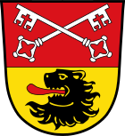
coat of arms
| Blazon : “Divided by red and gold; above two slanting silver keys, below a red-tongued black lion head. " | |
| Justification of the coat of arms: The crossed keys, attribute of the monastery patron saint Peter, have been taken over from the coat of arms of the Höglwörth monastery as the former manorial power in the municipality. The lion's head comes from the coat of arms of the Prince Archbishopric of Salzburg , to which Piding belonged as part of the Salzburg nursing court Staufeneck until it was incorporated into Bavaria in 1810. The former Staufeneck nursing court , once an important border festival for the archbishops of Salzburg, is located in the municipality. |
Culture and sights
theatre
- Pidinger Theater (farmer's theater with an annually changing stage play)
Buildings
Profane building
- Mauthausen in Mauthausen . First mentioned in 908. From 1275 customs post on the border between Bavaria and Salzburg on the salt road Reichenhall-Traunstein. When choosing the location for Staufeneck Castle, the close proximity to the already existing toll house was likely to have been the decisive factor. In 1440 it was sold to Bavaria. With the transition of the Rupertiwinkel to Bavaria, it had become functionless.
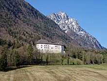
- Schloss Staufeneck (u Stauffenegg, Staufenägg Ä well..), One at the foot of Hochstaufen situated fortress . 1503-13 Archbishop Leonhard von Keutschach had the castle complex, built in 1240 by the Lords of Staufeneck, expanded and fortified . It served the Archbishopric of Salzburg from 1365 to 1805 a. a. for the Rupertiwinkel as a nursing court .
former toll house in Mauthausen
Sacred building
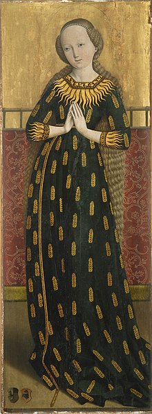
- Church Nativity , built around 1500 Roman Catholic parish church of the parish of the Nativity of Mary
- Church of St. Laurentius , built in the Romanesque style around 1200, probably on the site of a previous building, with very well-preserved Gothic frescoes a. a. the “ Holy Helper in Need ”, usually 14 in number, but here, for reasons of symmetry, added two to 15 after replacing another.
- Church of St. Johann on Johannishögl (viewpoint) with Gothic frescoes and an altar
Side altar by Gordian Guckh in St. Johann
Sports
- Indoor tennis center, tennis courts
- 50 km of hiking trails, 12 km of groomed trails
- Pidinger via ferrata on the Hochstaufen
- Multipurpose hall with beach volleyball and skate court
- Football field
- societies
- ASV Piding (soccer, men: district class)
- TC Piding (tennis, regional league)
Nature and culture
- Mountain flower garden at the foot of the Hochstaufen
- Natural and cultural-historical hiking trail
- Leisure facility at the castle pond
- Lattenbergstrasse leisure facility
- Pidinger via ferrata
Economy and Infrastructure
Established businesses
traffic
The federal motorway 8 (Munich – Salzburg) runs through Piding . The last motorway exit before the Austrian border, Bad Reichenhall , is in the municipality of Piding and connects the federal highway 20 to the motorway. Coming from Bad Reichenhall , the federal road continues past the town center to Freilassing . The state road 2103, branching off the B 20, runs from Piding to the neighboring municipality of Anger and connects to the B 304 in Teisendorf .
Piding has its own train station on the Freilassing – Berchtesgaden railway line , which is served by the S3 and S4 ( Berchtesgadener Land Bahn ) lines of the Salzburg S-Bahn . This means that there are direct local train connections from Piding via Bad Reichenhall to Berchtesgaden and via Freilassing (with connections to Munich and Mühldorf, among others), Salzburg to Schwarzach im Pongau . With the IC Königssee - which is designated as a local train in this section of the route - there is also an intercity stop in Piding from and to Hamburg .
Piding is connected to Bad Reichenhall, Freilassing, Anger, Reit im Winkl and Salzburg by bus with several lines from various operators .
education
- Piding primary school with 168 students
- Piding-Anger Middle School with 101 students
- Rupertus School Piding, private support center, support focus spirit. Development, the Catholic youth welfare of the Archdiocese of Munich and Freising with 64 students
- Pidinger workshops of the Lebenshilfe
Sons and daughters
- Josef Paar (1913–1997), German wrestler
literature
- Max Wieser: Pidinger Heimatbuch. From the chronicle of a village with a court and family history. 1250 years of Piding 735–1985 . Self-published, Piding 1985.
- Ronald Knöchlein: Migration and Bavarian times in the Rupertiwinkel , in: EM Feldinger (Ed.): Archeology on both sides of the Salzach. Archaeological finds from Flachgau and Rupertiwinkel , Salzburg 1996, pp. 111–127.
- Ronald Knöchlein: Studies on the Archeology of the Merovingian Period in Rupertiwinkel , Diss., Munich 1997.
Individual evidence
- ↑ "Data 2" sheet, Statistical Report A1200C 202041 Population of the municipalities, districts and administrative districts 1st quarter 2020 (population based on the 2011 census) ( help ).
- ^ Community Piding in the local database of the Bavarian State Library Online . Bavarian State Library, accessed on December 24, 2017.
- ↑ How the Bavarian farmers became - The Neolithic , Archaeological Lexicon of the Obermain Landscape Museum.
- ↑ Stephan Möslein: A ring bar deposit from Piding, district Berchtesgadener Land, Obb. , In: J. Prammer, RM Weiss (ed.): Excavations and finds in Altbayern 1995-1997. Special exhibition of the Gäubodenmuseum Straubing , Gäubodenmuseum, Straubing 1998, p. 52 f. and Ders .: New depot finds from the older Bronze Age from the Upper Bavarian Alpine Foreland. A preliminary report , in: Ders. Early Bronze Age depot finds in the Alpine Foreland - New Findings , Deggendorf 2008, pp. 69–77, here: pp. 72 f.
- ↑ Andreas Lippert, Günther Dembski: Another Celtic coin offering place at the Mallnitzer Tauern (Salzburg / Carinthia). The survey in 2011 , in: Archäologisches Korrespondenzblatt 43,4 (2013) 523-534, here: p. 531.
- ↑ Josef Ernst Ritter von Koch-Sternfeld: Historical and state-economic notes on road and hydraulic engineering and soil culture in the Duchy of Salzburg and Fürstenthume Berchtesgaden , Mayersche Buchhandlung, Salzburg 1811, p. 7.
- ^ Robert Kern: 150 Years of Bad Reichenhall Local History Museum , in: The Powder Tower. Announcements from the “Association for Local History Bad Reichenhall and Surroundings eV” (2004) 3–15, here: p. 5.
- ↑ Ronald Knöchlein: Studies on the Archeology of the Merovingian Period in the Rupertiwinkel , Diss., Munich 1997, p. 42 f.
- ↑ Wolf-Armin Frhr. v. Reitzenstein : Lexicon of Bavarian place names. Origin and meaning . CH Beck, Munich 2006, ISBN 3-406-55206-4 , p. 212 .
- ↑ Max Wieser: Pidinger Heimatbuch. From the chronicle of a village with a court and family history. 1250 years of Piding 735–1985 . Self-published, Piding 1985.
- ^ Anton von Steichele: The Diocese of Augsburg, historically and statistically described , Vol. 2: The land chapters Agenwang, Aichach, Baisweil, Bayer-Mänching, Burgheim , Schmid, Augsburg 1864, p. 713.
- ↑ Geologica Bavarica 84-86 (1983), p. 231.
- ^ Anton von Steichele: The Diocese of Augsburg, historically and statistically described , Vol. 2: The land chapters Agenwang, Aichach, Baisweil, Bayer-Mänching, Burgheim , Schmid, Augsburg 1864, p. 715 (there also the parish income for the time the publication of Streichele's work).
- ↑ In addition to Piding, Salzburg had previously included Ainring , Anger , Freilassing , Fridolfing , Kirchanschöring , Laufen, Palling , Petting , Saaldorf-Surheim , Surberg , Taching , Teisendorf , Tittmoning , Tyrlaching , Waging and Wonneberg .
- ↑ Laufen District Court: Historisches , 2nd paragraph, accessed on January 22, 2017.
- ^ E. Marschner: Schowanek Johann. In: Austrian Biographical Lexicon 1815–1950 (ÖBL). Volume 11, Verlag der Österreichischen Akademie der Wissenschaften, Vienna 1999, ISBN 3-7001-2803-7 , p. 155 f. (Direct links on p. 155 , p. 156 ).
- ↑ Unsourced information on this in the article Piding , online at bgl.wiki
- ↑ Bavarian State Office for Statistics and Data Processing (Hrsg.): The municipalities of Bavaria according to the territorial status May 25, 1987. The population of the municipalities of Bavaria and the changes in the acquisitions and territory from 1840 to 1987 (= contributions to Statistics Bavaria . Issue 451). Munich 1991, p. 41 , urn : nbn: de: bvb: 12-bsb00070717-7 ( digitized version - footnote 8).
- ↑ Max Wieser: Pidinger Heimatbuch. From the chronicle of a village with a court and family history. 1250 years of Piding 735–1985 . Self-published, Piding 1985.
- ↑ a b Municipality of Piding in Bayer. State Office f. Statistics and Data processing , online at statistik.bayern.de , PDF file p. 6 of 29 pages
- ↑ List of the first mayors / lords in municipalities belonging to the district (status: January 19, 2016) via entry piding in the search mask
- ^ Entry on the coat of arms of Piding in the database of the House of Bavarian History
- ↑ General SV Piding , website of the Bavarian Football Association , online at bfv.de
Web links
- Official website of the municipality of Piding
- Entry on the coat of arms of Piding in the database of the House of Bavarian History


