
Swan field
| coat of arms | Germany map | |
|---|---|---|

|
Coordinates: 49 ° 55 ' N , 10 ° 8' E |
|
| Basic data | ||
| State : | Bavaria | |
| Administrative region : | Lower Franconia | |
| County : | Schweinfurt | |
| Management Community : | Swan field | |
| Height : | 242 m above sea level NHN | |
| Area : | 12 km 2 | |
| Residents: | 1799 (Dec. 31, 2019) | |
| Population density : | 150 inhabitants per km 2 | |
| Postal code : | 97523 | |
| Area code : | 09384 | |
| License plate : | SW , GEO | |
| Community key : | 09 6 78 175 | |
| LOCODE : | DE SWQ | |
| Community structure: | 3 districts | |
| Address of the municipal administration: |
Rathausplatz 6 97523 Schwanfeld |
|
| Website : | ||
| Mayoress : | Lisa Krein ( Schwanfelder List ) | |
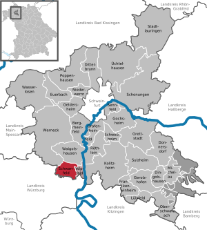
| Location of the community Schwanfeld in the district of Schweinfurt | ||
  |
||

Schwanfeld is a municipality in the Lower Franconian district of Schweinfurt and the seat of the Schwanfeld administrative community .
geography
Schwanfeld is located in the Main-Rhön region.
Community structure
Schwanfeld is divided into three districts:
- Heiligenthal
- Neuheiligenthal
- Swan field
There is only the Schwanfeld district .
Neighboring communities
Neighboring communities are (starting from the north clockwise): Waigolshausen , Wipfeld , Eisenheim , Bergtheim and Werneck .
history
Until the church is planted
Schwanfeld is considered to be the oldest village in Germany, even if there is no evidence of continuous settlement. It is certain that band ceramists settled down there around 7,500 years ago, farmed and lived in houses. The finds from this era are exhibited in the Bandkeramik -Museum.
Schwanfeld was first mentioned in a document in 772. In 1234 the Heiligenthal monastery was founded. The Schwanfeld Jewish community was founded in the middle of the 16th century; In 1579 the local Jewish cemetery was built .
The office of Klingenberg of the Würzburg bishopric was with Schwanfeld from 1500 in the Franconian Empire . The official seat was moved to Schwanfeld in 1792, and the office was then referred to as Amt Schwanfeld. In 1803 it fell to Bavaria, which in 1805 ( Peace of Preßburg ) exchanged it with the Grand Duchy of Würzburg of Archduke Ferdinand of Tuscany . In the course of the administrative reforms in Bavaria , today's municipality was created with the municipal edict of 1818 .
Population development

Architectural monuments

Parish Church of St. Michael

Monastery church in Heiligenthal

Jewish cemetery near Schwanfeld


politics
mayor
Lisa Krein (Schwanfelder List) has been mayor since May 1, 2020; she was elected with a voter turnout of 65.4% on March 15, 2020 with 83.1% of the vote. Her predecessor was Richard Köth (CSU / BLS), in office from May 2008 to April 2020.
Municipal council
For the 2020 local elections , only the Schwanfelder List submitted an election proposal; the twelve applicants with the most votes form the municipal council.
coat of arms
Schwanfeld has had a coat of arms since 1576; it was confirmed on April 27, 1962. The description reads: “Standing in blue on a green ground is a gold-armored, silver swan, who wears a little silver tag on a red ribbon around his neck; in it three or two black balls placed to one and connected to one another ”.
Economy and Infrastructure
Economy including agriculture and forestry
In 1998, according to official statistics, there were no employees at the place of work in the manufacturing sector 112 or in the trade and transport sector. In other economic areas, 80 people were employed at the place of work subject to social security contributions. There were a total of 672 employees at the place of residence subject to social security contributions. There was one company in the manufacturing sector and two companies in the main construction sector. In addition, in 1999 there were 33 farms with an agricultural area of 657 hectares, of which 621 hectares were arable land and 34 hectares were permanent green areas.
Viticulture
Today Schwanfeld is a wine-growing area in the Franconian wine-growing region . There is a vineyard around the village, the wine has been marketed under the name Schwanfelder Mühlberg since the 1970s, the name referring to the two mills around the village. Schwan field is part of the range Volkacher Main loop until 2017, the wineries in area were Maindreieck summarized. The limestone soils around Schwanfeld are also suitable for growing wine, as is the location in the Maingau climate zone, which is one of the warmest in Germany.
The people around Schwanfeld have been viticulture since the early Middle Ages . The Franconian settlers probably brought the vine to the Main in the 7th century. The vine around the place was first mentioned in the 12th century in a document from Heiligenthal Abbey. In the Middle Ages, the region was part of the largest contiguous wine-growing region in the Holy Roman Empire. The people mostly operated part-time viticulture for self-sufficiency , at the same time export centers were already emerging, especially along the Main.
Viticulture experienced a major decline after secularization at the beginning of the 19th century. Above all, locations with less favorable climatic conditions were completely abandoned. In addition, the emergence of pests such as phylloxera made cultivation difficult . The Franconian wine-growing region was not able to consolidate again until the second half of the 20th century. The use of fertilizers and improved cultivation methods had contributed to this, as had the organization in cooperatives and the land consolidation of the 1970s. The Schwanfelder Weinlage takes up only a small area, only a part-time winemaker operates viticulture in the place.
| Vineyard | Size 1993 | Size 2017 | Compass direction | Slope | Main grape varieties | Great location |
|---|---|---|---|---|---|---|
| Muhlberg | 5 ha | 4 ha | southwest | 25% | Müller-Thurgau | Volkacher Kirchberg |
traffic
The state road St 2270 leads through Schwanfeld.
Education and culture
The following institutions exist (as of 2017):
- Catholic kindergarten St. Michael with 100 places
- primary school
On October 16, 2010 the Bandkeramik-Museum Schwanfeld was opened in Schwanfeld . Its exhibits deal with the band ceramic culture and depicts the life of the oldest Central European rural culture of the Neolithic Age (Neolithic) 7500 years ago.
Personalities
- Jacob Elkan (1742–1805), court factor in Weimar
literature
- Hans Ambrosi, Bernhard Breuer: German Vinothek: Franconia. Guide to the vineyards, winegrowers and their kitchens . Herford 2 1993.
Web links
- Entry on Schwanfeld's coat of arms in the database of the House of Bavarian History
Individual evidence
- ↑ "Data 2" sheet, Statistical Report A1200C 202041 Population of the municipalities, districts and administrative districts 1st quarter 2020 (population based on the 2011 census) ( help ).
- ↑ http://www.bayerische-landesbibliothek-online.de/orte/ortssuche_action.html ? Anzeige=voll&modus=automat&tempus=+20111114/223439&attr=OBJ&val= 1770
- ^ Ambrosi, Hans (among others): German Vinothek: Franconia . Pp. 50-52.
- ^ Government of Lower Franconia: Vineyards in Bavaria broken down by area , PDF file, accessed on May 16, 2019.
- ^ Ambrosi, Hans (among others): German Vinothek: Franconia . P. 237.
- ^ Official website of the Bandkeramik-Museum

Bergrheinfeld | Dingolshausen | Dittelbrunn | Donnersdorf | Euerbach | Frankenwinheim | Geldersheim | Gerolzhofen | Gochsheim | Grafenrheinfeld | Grettstadt | Kolitzheim | Lülsfeld | Michelau im Steigerwald | Niederwerrn | Oberschwarzach | Poppenhausen | Röthlein | Sparing | Swan field | Schwebheim | Sennfeld | Stadtlauringen | Sulzheim | Üchtelhausen | Waigolshausen | Waterless | Werneck | Wipfeld
Unregulated areas in the district of Schweinfurt
Bürgerwald |
Geiersberg |
Hundelshausen |
Nunnery |
Stollbergerforst |
Vollburg |
Wustvieler forest