
Kolitzheim
| coat of arms | Germany map | |
|---|---|---|

|
Coordinates: 49 ° 55 ' N , 10 ° 14' E |
|
| Basic data | ||
| State : | Bavaria | |
| Administrative region : | Lower Franconia | |
| County : | Schweinfurt | |
| Height : | 229 m above sea level NHN | |
| Area : | 59.1 km 2 | |
| Residents: | 5610 (Dec. 31, 2019) | |
| Population density : | 95 inhabitants per km 2 | |
| Postal code : | 97509 | |
| Primaries : | 09385, 09381, 09723 | |
| License plate : | SW , GEO | |
| Community key : | 09 6 78 150 | |
| LOCODE : | DE KZM | |
| Community structure: | 11 districts | |
| Address of the municipal administration: |
Rathausstrasse 1 97509 Kolitzheim |
|
| Website : | ||
| Mayor : | Horst Herbert ( CSU ) | |
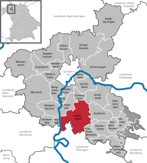
| Location of the community Kolitzheim in the district of Schweinfurt | ||
  |
||

Kolitzheim is a municipality in the district of Schweinfurt in Lower Franconia . The large community is the gateway from the Schweinfurt area to the Volkacher Mainschleife and the tenth largest wine-growing community in the Franconian wine-growing region .
geography
Kolitzheim is located between Schweinfurt and Volkach , on the southern edge of the Schweinfurt basin , at the foot of the Gaibacher Berg. Schweinfurt, Gerolzhofen and the Steigerwald are within sight of the southern municipality.
Community structure
Kolitzheim is divided into eleven districts:
There are the districts of Gernach, Herlheim, Kolitzheim, Lindach, Oberspiesheim, Stammheim , Unterspiesheim and Zeilitzheim .
Neighboring communities
Neighboring communities are (starting from the north clockwise): Schwebheim , Grettstadt , Sulzheim , Frankenwinheim , Volkach , Eisenheim , Wipfeld and Röthlein .
history
Until the church is planted
The place name appeared as "Coldleibesheim" as early as 791, when the landlord Hiltrich and his wife Hruandun gave goods to the Fulda monastery. The author Friedrich Abel assumes that the place was founded as a Franconian settlement around 600 by a Merovingian named Coldleib. Coldleibesheim became "Coldosheim" and "Collosheim", later "Coldsheim" and "Collshem". When the German language became predominant in the documents in the 14th century, it was called "Kolotsheim", "Koleczheim" and "Koliczheim".
In 1796 the French Revolutionary Army occupied Franconia. On the night of July 24 was Kolitzheim of dragoons invaded and pillaged . The marching through of French battalions lasted for days . The population lived in terrible fear. In this need the people of Kolitzheim took a vow : To avert further war distress, they promised to hold a 33-hour prayer every year from Good Friday morning to Holy Saturday evening. This vow is kept to this day.
As part of the high pin Würzburg Kolitzheim was in 1803 in Bavaria's favor secularized , then in the Peace of Pressburg in 1805 Archduke Ferdinand of Tuscany to form the Grand Duchy of Wurzburg left with which it finally at 1814 Bavaria fell. In the course of the administrative reforms in Bavaria, the municipality of Kolitzheim was created with the municipal edict of 1818 . It became part of the former district of Gerolzhofen.
District affiliation
The Gerolzhofen district was dissolved in 1972 and the Kolitzheim community became part of the Schweinfurt district.
Incorporations
On May 1, 1978 the place Kolitzheim became the seat of the municipality Kolitzheim, which was newly constituted in the course of the Bavarian municipality reform, with the formerly eight independent municipalities Kolitzheim, Gernach, Unterspiesheim, Oberspiesheim, Lindach, Stammheim, Herlheim and Zeilitzheim.
Population development
Population development since 1840:
|
|
|
The inhabitants of the municipality of Kolitzheim are distributed among the districts as follows (as of June 30, 2019):
| Part of the community | Main residence | Adjoining apartment | All in all |
|---|---|---|---|
| Gladly | 511 | 34 | 545 |
| Herlheim | 477 | 23 | 500 |
| Kolitzheim | 732 | 38 | 770 |
| Lindach | 516 | 23 | 539 |
| Oberspiesheim | 611 | 27 | 638 |
| Stammheim | 852 | 51 | 903 |
| Unterspiesheim | 1240 | 58 | 1298 |
| Zeilitzheim | 662 | 36 | 698 |
| All in all | 5601 | 290 | 5891 |
politics
mayor
Horst Herbert (CSU) has been mayor since May 1, 1996; he was last elected on March 15, 2020 with a turnout of 75.5% with 61.4% of the votes for a further six years.
badges and flags
The coat of arms was approved by the government of Lower Franconia on January 18, 1982.
Blazon : "Under a red shield head, in it three lowered silver tips, a golden cross-stick and a golden abbot's stick crossed diagonally in blue, above a golden bunch of grapes."
The municipality of Kolitzheim has consisted of the formerly independent municipalities of Gernach, Herlheim, Kolitzheim, Lindach, Oberspiesheim, Stammheim and Zeilitzheim since 1978. The Würzburg bishopric had manorial rights in all of the above-mentioned parts of the community; Herlheim was one of the 742 royal own churches donated by Karlmann to the foundation of the diocese of Würzburg. In addition to the large Würzburg monasteries, such as St. Stephan, the Maidbronn and Ebrach monasteries, as well as the Haug and Heidenfeld monasteries, owned what is now the municipality. As a reference to the ecclesiastical landlord, the municipal coat of arms shows a cross staff and abbot staff. The Würzburg bishopric is represented by its coat of arms, the Franconian rake . The bunch of grapes was chosen as an additional coat of arms because of the viticulture that is particularly practiced in the Stammheim district.
Flag: red-yellow-blue.
Culture and sights

- Every year on the last weekend in July, the street wine festival takes place in Stammheim, the largest wine-growing town in the Schweinfurt district.
- Once a year, the vineyard hike (May 1st) and the street wine festival (1st weekend in August) take place in the Lindach district. The Franconian wine from Lindach and food made according to traditional recipes are presented and sold.
- Museum for military and contemporary history in Stammheim am Main
- The Zeilitzheim Castle cultural center with an annual cultural program. The operator, the von Halem family, received the German Prize for Monument Protection in 2004 for the restoration and use of the castle.
- A wine festival takes place on the third weekend in August on the Zeilitzheim market square.
- On the second weekend in July, the wind music days in Gernach with the Benfiz village run on Sunday (400, 1,000, 4,000, 6,000 and 10,000 meters).
- The annual Unterspiesheim beer festival
- The Fendt Field Days at Gut Wadenbrunn, each with more than 50,000 visitors from all over Europe.
Architectural monuments
Economy and Infrastructure
The districts of Kolitzheim and Unterspiesheim are crossed by the state road 2271 .
Economy including agriculture, forestry and viticulture
According to official statistics, there were 82 employees at the place of work in the field of agriculture and forestry, 203 in the manufacturing sector and 47 in trade and transport. In other economic sectors 114 people were employed at the place of work subject to social security contributions . There were a total of 1920 employees at the place of residence subject to social security contributions. There were two companies in the manufacturing sector and four in the construction sector. In addition, in 1999 there were 306 farms with an agricultural area of 5,460 hectares, of which 4,958 hectares were arable land and 235 hectares were permanent green space. In 2017 the vineyard area was 160 hectares.
The solar energy company Belectric is based in Kolitzheim.
education
The following institutions exist (2004):
- six kindergartens
- a primary school (with school buildings in Herlheim, headquarters of the school administration, Zeilitzheim, Stammheim)
Personalities
Sons and daughters of the church
- Henry VI. Porter († 1646), German Cistercian abbot, born in the Unterspiesheim district
- Adolf Wächter (1873–1954), Lord Mayor of Bamberg, born in the Herlheim district
- Franz Herbert (1885–1945), German politician and martyr
- Valentin Müller (1891–1951), German doctor
Personalities who have worked on site
- Heinz Miederer (1928–1990), pastor and rector of Diakonie Neuendettelsau; from 1956 to 1963 he was pastor in Zeilitzheim
Web links
- Gernach district
- Unterspiesheim district
- Entry on the Kolitzheim coat of arms in the database of the House of Bavarian History
Individual evidence
- ↑ "Data 2" sheet, Statistical Report A1200C 202041 Population of the municipalities, districts and administrative districts 1st quarter 2020 (population based on the 2011 census) ( help ).
- ↑ http://www.bayerische-landesbibliothek-online.de/orte/ortssuche_action.html ? Anzeige=voll&modus=automat&tempus=+20111114/213158&attr=OBJ&val= 1762
- ^ Karl Treutwein : From Abtswind to Zeilitzheim
- ^ Friedrich Abel: From the life and history of the Würzburg village of Kolitzheim up to 1803
- ^ Karl Treutwein: From Abtswind to Zeilitzheim
- ^ Federal Statistical Office (ed.): Historical municipality directory for the Federal Republic of Germany. Name, border and key number changes in municipalities, counties and administrative districts from May 27, 1970 to December 31, 1982 . W. Kohlhammer GmbH, Stuttgart / Mainz 1983, ISBN 3-17-003263-1 , p. 753 .
- ↑ Municipal statistics 2013 - A selection of important statistical data for the municipality of Kolitzheim ( Memento of the original from September 11, 2014 in the Internet Archive ) Info: The archive link was inserted automatically and has not yet been checked. Please check the original and archive link according to the instructions and then remove this notice. . Website of the Kolitzheim community. Retrieved September 11, 2014.
- ^ Kolitzheim parish
- ↑ Bavarian State Institute for Viticulture and Horticulture (LWG) Veitshöchheim: List of vineyards in the vineyards, planted vineyards on July 31, 2017.

Bergrheinfeld | Dingolshausen | Dittelbrunn | Donnersdorf | Euerbach | Frankenwinheim | Geldersheim | Gerolzhofen | Gochsheim | Grafenrheinfeld | Grettstadt | Kolitzheim | Lülsfeld | Michelau im Steigerwald | Niederwerrn | Oberschwarzach | Poppenhausen | Röthlein | Sparing | Swan field | Schwebheim | Sennfeld | Stadtlauringen | Sulzheim | Üchtelhausen | Waigolshausen | Waterless | Werneck | Wipfeld
Unregulated areas in the district of Schweinfurt
Bürgerwald |
Geiersberg |
Hundelshausen |
Nunnery |
Stollbergerforst |
Vollburg |
Wustvieler forest
Gernach | Herleshof | Herlheim | Kolitzheim | Lindach | Lohmühle | Oberspiesheim | Stammheim | Unterspiesheim | Wadenbrunn | Zeilitzheim