
Redness
| coat of arms | Germany map | |
|---|---|---|

|
Coordinates: 49 ° 59 ' N , 10 ° 13' E |
|
| Basic data | ||
| State : | Bavaria | |
| Administrative region : | Lower Franconia | |
| County : | Schweinfurt | |
| Height : | 206 m above sea level NHN | |
| Area : | 19.09 km 2 | |
| Residents: | 4505 (Dec. 31, 2019) | |
| Population density : | 236 inhabitants per km 2 | |
| Postal code : | 97520 | |
| Area code : | 09723 | |
| License plate : | SW , GEO | |
| Community key : | 09 6 78 170 | |
| LOCODE : | DE RTI | |
| Community structure: | 3 parts of the community | |
| Address of the municipal administration: |
Elmußweg 1 97520 Röthlein |
|
| Website : | ||
| Mayor : | Peter Gehring (CSU & Free Voting Community) | |
| Location of the community Röthlein in the district of Schweinfurt | ||
  |
||

Röthlein is a municipality in the district of Schweinfurt in Lower Franconia .
geography
The community is located south of Schweinfurt near the Main Valley .
Community structure
Röthlein is divided into the following locations:
- Heidenfeld
- Hirschfeld
- Redness

In the course of time, several new development areas were designated. The last ones were An der Tränke I in 2016 (29 building sites) and Elmuss II. Section in 2004 (79 building sites). Most of the building sites were sold quickly. Existing building gaps should be closed with priority.
Neighboring communities
Neighboring communities are (starting from the north in a clockwise direction): Grafenrheinfeld , Schwebheim , Kolitzheim , Wipfeld , Waigolshausen and Bergrheinfeld .
climate
In terms of climate, Röthlein has an average annual temperature of 8 ° C and an average rainfall of 600 millimeters per year.
history
Already in the 7th / 8th In the 19th century, Heidenfeld was of great importance as a center court in Volkfeldgau. With the founding of the Heidenfeld Monastery, the village was first mentioned as "Heidenvelt". The Augustinian Canons' Monastery was founded around 1069 and handed over to Bishop Adalbero of Würzburg by the founder, Alberada, Margravine von Schweinfurt and her husband Hermann von Habsberg-Kastl . In the heyday of the monastery, the Augustinian monks of the canon monastery looked after over 30 places in the area or had their widely scattered possessions there. In 1525 the wealthy monastery burned down during the Peasants' War and again in 1554 during the Markgräfler War . The destroyed buildings were supposed to be rebuilt by the baroque master builder Balthasar Neumann , of which only the actual monastery buildings were completed, which have largely been preserved with their valuable stucco furnishings. After secularization , the monastery complex was initially privately owned, but came back into the possession of the church via detours and serves the nuns of the congregation of the Sisters of the Redeemer as a retirement and nursing home. The bones of the martyr priest Liborius Wagner, who was beatified on March 24, 1974, rest in the parish church of St. Laurentius in Heidenfeld, built in 1906 . Since then, many pilgrims have come to Heidenfeld to worship the Blessed; This admiration culminated in the celebration of the 350th year of death in 1981.
Hirschfeld was mentioned in a document from King Heinrich IV in 1060 as "Hirzvurtin". This name has often been interpreted as a ford frequented by deer in the Main, and there is some speculation that it refers to a person named Hirz. But it is also conceivable that the name is derived from the grain that was most commonly grown in ancient times and the Middle Ages, millet (Middle High German "hirs" or "millet"), or from the Latin hiscare (gape, open), because Hirschfeld is located at the transition from the comparatively narrow central Main Valley with its steep, limestone slopes, which are particularly suitable for viticulture, to the Schweinfurt basin , which opens wide to the north and is characterized by the slightly eroding, clayey and therefore well-suited Lettenkeuper . The settlement was owned by the Schweinfurt margraves early on. In the Middle Ages, the Würzburg Monastery and the Heidenfeld Monastery were wealthy there. In 1700 the parish church of St. Kilian was rebuilt. In 1814 Hirschfeld came to Bavaria together with most of Franconia . Hirschfeld suffered from floods every year due to its proximity to the Main. During the Second World War , the place suffered severe destruction in February 1944 and May 1945.
Röthlein was first mentioned in 1179 as an independent village. Settlement contexts and the oldest forms of the spelling of place names indicate that Röthlein grew out of a small clearing on the Rheinfeld district ("Rothreinfeld"). Parts of the place were sold to the Würzburg cathedral chapter in the 12th century. Since the end of the Middle Ages, this has been in the undisputed possession of the community and village rulers Röthlein. Röthlein was a branch of the Grafenrheinfeld parish in the Middle Ages . 1744 saw the construction of the own church, consecrated to the Apostle James the Elder; it was replaced in 1893/94 by today's new building. Röthlein's economy was previously characterized by fishing, running a mill and commercial horticulture (herb crops).
Through extensive historical research it was established that the original community "Rheinfeld" was first mentioned on November 21, 889. For this reason, the present-day communities of Bergrheinfeld , Grafenrheinfeld , Oberndorf and Röthlein , which belong to the original community, celebrated their 1100th anniversary in 1989/90.
The unitary community of Röthlein is located in the bend of the Main River in the Schweinfurt basin , which is open to the south, near the district town of Schweinfurt and covers an area of 1911 hectares. Schweinfurt offers jobs to many commuters . Full-time and part-time farmers still use 1,106 hectares. In 1972 the former municipalities were awarded the first prize for exemplary land consolidation by the Bavarian Ministry of Agriculture.
The new development areas with typical rural residential character fit harmoniously into the largely flat country. The community is supplied with drinking water by the Rhön-Maintal Group. The wastewater disposal for the municipal parts of Heidenfeld and Röthlein is carried out by the Zweckverband Unterer Unkenbach with the sewage treatment plant in Heidenfeld and for the municipal part of Hirschfeld by the Zweckverband Stammheimer Gruppe with the sewage treatment plant in Stammheim .
In the past few years the community has grown rapidly. In 1986 a new community building yard was built in the Mühläcker industrial park and equipped with the necessary equipment and vehicles.
Because of the limited space in the two previous school buildings in Heidenfeld and Röthlein, the community began building a new elementary school in Röthlein in 1988 , which ended at the beginning of the 1989/90 school year and was handed over to its intended purpose. The steady increase in the number of residents required the addition of three more classrooms in 1995.
International understanding was taken into account with the signing of partnership documents in 1989/90 with the French community of Cormelles le Royal in Normandy. The partnership committee is responsible for maintaining the partnership. In May 1999 the tenth anniversary of the partnership and in 2009 the twentieth anniversary were celebrated with festivities lasting several days.
religion
Röthlein's landmark is his church, built in the neo-Gothic style in 1893/95 for the Catholic parish. The parish church, consecrated to Jakobus the Elder, was built by the former Röthlein citizen Adam Nikolaus, master builder in Munich with the help of the residents. At this time the place had the reputation of a “bricklayer's village”, as the farms could not offer work to all family members.
The highest church tower in the district of Schweinfurt at 44 meters and the high nave tower over the village silhouette in all directions. A small church stood in the same place until 1893, which was built in 1744 based on plans by Balthasar Neumann.
An upright, life-size statue of St. James, carved from French limestone, adorns the outer facade above the portal. Standing on an ornate console and roofed over with a canopy on which a decorative turret, a so-called pinnacle , is placed, the figure of James is equipped with the same insignia, the staff and the sword, as the wooden sculpture on the side altar. The Würzburg sculptor Nikolaus Köstner created the statue of the church patron in 1893.
Incorporations
On May 1, 1978 the formerly independent communities Heidenfeld and Hirschfeld were incorporated into the Röthlein community.
Population development
- 1961: 3032 inhabitants
- 1970: 3521 inhabitants
- 1991: 4311 inhabitants
- 1995: 4674 inhabitants
- 2003: 4855 inhabitants
- 2004: 4897 inhabitants
- 2005: 4905 inhabitants
- 2006: 4895 inhabitants
- 2007: 4838 inhabitants
- 2008: 4826 inhabitants
- 2009: 4784 inhabitants
- 2010: 4769 inhabitants
- 2011: 4573 inhabitants
- 2012: 4544 inhabitants
- 2013: 4584 inhabitants
- 2014: 4545 inhabitants
- 2015: 4561 inhabitants
- 2016: 4492 inhabitants
- 2017: 4506 inhabitants
- 2018: 4538 inhabitants
numbers, data, facts
surface
| Buildings and open spaces | 93 ha |
| Forest areas | 364 ha |
| Green spaces | 13 ha |
| Bodies of water | 23 hectares |
| Traffic areas | 140 ha |
| other areas | 29 hectares |
| agricultural land | 1249 ha |
Residents
| male | Female |
|---|---|
| 49.44% | 50.56% |
Röthlein, Heidenfeld and Hirschfeld:
| Redness | Heidenfeld | Hirschfeld |
|---|---|---|
| 2516 | 1667 | 782 |
4693 residents are registered with their main residence.
religion
| Catholic | Evangelical | Others |
|---|---|---|
| 72.72% | 12.82% | 14.46% |
politics
mayor
Mayor has been Peter Gehring (CSU / Free Voting Community Hirschfeld) since May 1, 2020; he was elected on March 15, 2020 with 54.1% of the vote. His predecessor was Albrecht Hörmann (Free Citizen List) from May 1, 2008 to April 30, 2020.
Municipal council
The council has 16 members (excluding the mayor).
- CSU and Free Voting Community 4 seats
- Free voter community Hirschfeld (FWGH) 4 seats
- SPD and Free Citizens 2 seats
- Christian voter community Heidenfeld (CWG) 2 seats
- Free list of citizens Hirschfeld, Heidenfeld, Röthlein (FBL) 2 seats
- Independent voter community Heidenfeld (UWG) 1 seat
- List of Democratic Voters, Röthlein, Heidenfeld (LDW) 1 seat
(Status: local election on March 15, 2020)
coat of arms
The motifs of the coat of arms of the large community of Röthlein symbolize the three parts of the community Heidenfeld , Hirschfeld and Röthlein: The golden paw cross ( Mauritius cross) on a blue background was part of the former Augustinian monastery of Heidenfeld, today's monastery "Maria Hilf". The district of Hirschfeld is pictorially represented by the two antlers. The two fish point to the Röthlein part of the municipality, whose inhabitants used to live mainly from fishing, as Röthlein has only been located 4 km southeast of the river since the Main Regulation was introduced.
Parish partnership
Partner municipality is:
Culture and sights
Buildings

- Pilgrimage Church of St. Laurentius Heidenfeld , contains the relics of Blessed Liborius Wagner (1593–1631, beatified by Pope Paul VI in 1974)
- Maria Hilf monastery (in the district of Heidenfeld )
- St. Jakobus Church (in the Röthlein district)
Architectural monuments
Parks

- Partnership garden created on the occasion of the 20th anniversary of the partnership with the municipality of Cormelles-le-Royal.
Regular events
- Parish fair in Heidenfeld
- Röthleiner Kirchweih (last weekend in June)
- Parish fair in Hirschfeld
- Feast of Blessed Liborius Wagner on December 9th every year in Heidenfeld
- Norman market
- Fish festival in Heidenfeld and Röthlein
- The car-free Sunday
- Thanksgiving
- Street festival in Hirschfeld
- DJK festival in Hirschfeld
- Christmas Market
Economy and Infrastructure
traffic
Via the Schwebheim / Röthlein exit of the B 286 you get to Röthlein. The Etzberg industrial area is right at the exit . The state road St 2277 leads through Röthlein.
Industrial site Röthlein
The Mühläcker industrial park has been growing steadily since the mid-1980s . Local craft businesses were able to expand there, and new industries could settle there. The favorable traffic situation next to the B 286 motorway slip road to the A3 to Nuremberg and the proximity to the south industrial and commercial area of the city of Schweinfurt make the Röthlein location attractive. New companies have settled in the 25 hectare industrial area Etzberg in Röthlein.
Transportation
In the large community of Röthlein, every part of the community is connected to the public transport network of the Verkehrsgemeinschaft Schweinfurt through several bus stops in the towns.
Education and culture
There is a community library and a primary school in the Röthlein district. For the common good of the citizens, different public institutions are distributed over the three parts of the municipality. So today z. For example, in the former kindergarten building in Röthlein (built in 1913/14 as a children's custody facility) the Catholic parish home, in which the Protestant citizens, who are in the minority in all three parts of the community, regularly celebrate church services. They are also looked after by the neighboring community of Schwebheim. There is a youth club in the basement of the extension. At the end of the street (Landrat-Wolf-Straße, named after a well-deserved citizen of the municipality) in the Bäckertorstraße (the name comes from the village fortifications from earlier centuries) stands the old schoolhouse, which was built in 1903/04 as a single storey and during the war was destroyed. The community library has been set up there since 1982.
In the Röthlein part of the municipality there is a primary school with around 180 students.

Center of Röthlein
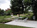
The partnership garden in Röthlein

The town hall of the Röthlein community
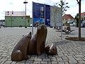
The Röthlein bears

The Röthlein Church of St. Jakobus


Sons and daughters of the church
- Michael von Faulhaber (1869–1952), Archbishop of Munich and Freising since 1917 and cardinal from 1921.
- Hubert Franz Maria Graf von Andlau-Homburg (1868–1959), Alsatian nobleman, landowner and politician.
Web links
- www.roethlein.de
- Entry on Röthlein’s coat of arms in the database of the House of Bavarian History
Individual evidence
- ↑ "Data 2" sheet, Statistical Report A1200C 202041 Population of the municipalities, districts and administrative districts 1st quarter 2020 (population based on the 2011 census) ( help ).
- ↑ http://www.bayerische-landesbibliothek-online.de/orte/ortssuche_action.html ? Anzeige=voll&modus=automat&tempus=+20111114/221650&attr=OBJ&val= 1768
- ↑ a b c Federal Statistical Office (ed.): Historical municipality directory for the Federal Republic of Germany. Name, border and key number changes in municipalities, counties and administrative districts from May 27, 1970 to December 31, 1982 . W. Kohlhammer GmbH, Stuttgart and Mainz 1983, ISBN 3-17-003263-1 , p. 753 .

Bergrheinfeld | Dingolshausen | Dittelbrunn | Donnersdorf | Euerbach | Frankenwinheim | Geldersheim | Gerolzhofen | Gochsheim | Grafenrheinfeld | Grettstadt | Kolitzheim | Lülsfeld | Michelau im Steigerwald | Niederwerrn | Oberschwarzach | Poppenhausen | Röthlein | Sparing | Swan field | Schwebheim | Sennfeld | Stadtlauringen | Sulzheim | Üchtelhausen | Waigolshausen | Waterless | Werneck | Wipfeld
Unregulated areas in the district of Schweinfurt
Bürgerwald |
Geiersberg |
Hundelshausen |
Nunnery |
Stollbergerforst |
Vollburg |
Wustvieler forest