
Grettstadt
| coat of arms | Germany map | |
|---|---|---|

|
Coordinates: 49 ° 59 ' N , 10 ° 19' E |
|
| Basic data | ||
| State : | Bavaria | |
| Administrative region : | Lower Franconia | |
| County : | Schweinfurt | |
| Height : | 232 m above sea level NHN | |
| Area : | 34.93 km 2 | |
| Residents: | 4226 (Dec. 31, 2019) | |
| Population density : | 121 inhabitants per km 2 | |
| Postal code : | 97508 | |
| Area code : | 09729 | |
| License plate : | SW , GEO | |
| Community key : | 09 6 78 138 | |
| LOCODE : | DE TAD | |
| Community structure: | 4 districts | |
| Address of the municipal administration: |
Main street 1 97508 Grettstadt |
|
| Website : | ||
| Mayor : | Ewald Vögler | |
| Location of the municipality of Grettstadt in the district of Schweinfurt | ||
  |
||

Grettstadt is a municipality in the district of Schweinfurt in Lower Franconia .
geography
Grettstadt is located in the Main-Rhön region.
Community structure
There are four parts of the community, the two parish villages Grettstadt and Obereuerheim and the two church villages Dürrfeld and Untereuerheim and four districts of the same name .
Neighboring communities
Neighboring communities are (starting from the north clockwise): Gädheim , Theres , Donnersdorf , Sulzheim , Kolitzheim , Schwebheim and Gochsheim .
history
Until the 19th century
Grettstadt is mentioned for the first time in 880. In deeds of donation around 1100, the noble free "Sigeloch von Grezzistat" is mentioned several times, which includes Korb bei Möckmühl . During the Second Margrave War (1552–1554), Grettstadt, like many other Franconian settlements, was plundered and burned down. As part of the high pin Würzburg , which for 1500 Franconian Circle belonged Grettstadt was in 1803 in Bavaria's favor secularized , then in the Peace of Pressburg in 1805 Archduke Ferdinand of Tuscany to form the Grand Duchy of Wurzburg left with which it finally at 1814 Bavaria fell back. In the course of the administrative reforms in Bavaria, today's municipality was created with the municipal edict of 1818 . In 1870, 169 families lived in Grettstadt's 117 residential buildings, all of which were exclusively Catholic.
Religions
- Roman Catholic
- Grettstadt: Parish of St. Peter and Paul , is looked after by Unterspiesheim
- Obereuerheim: Parish of St. Laurentius
- Untereuerheim: Curatie St. Gallus , supervised by Obereuerheim
- Dürrfeld: Branch of the Birth of Mary in the parish of Pusselsheim
- Evangelical
- The entire community area is looked after by the Protestant parish of Gochsheim ; there are no Protestant church buildings in the community area.
Incorporations
On July 1, 1971, the previously independent municipality of Dürrfeld was incorporated. On May 1, 1978 Obereuerheim and Untereuerheim were added.
Population development
- 1838: 500 inhabitants
- 1870: 662 inhabitants
- 1961: 3178 inhabitants
- 1970: 3346 inhabitants
- 1987: 3527 inhabitants
- 1991: 3709 inhabitants
- 1995: 3887 inhabitants
- 2000: 4115 inhabitants
- 2005: 4165 inhabitants
- 2010: 4121 inhabitants
- 2015: 4211 inhabitants
politics
mayor
Ewald Vögler (Free Association of Voters) has been the full-time first mayor since October 13, 2010. This was elected on July 10, 2016 with 63.0% of the votes and a turnout of 62.1% for a further six years.
Municipal council
The municipal council consists of the first mayor and 16 members. The municipal council election on March 15, 2020 had the following result:
| Seats | Share of votes | |
|---|---|---|
| CSU | 4th | 22.08% |
| SPD / Free Citizens | 2 | 10.55% |
| Free voter community Obereuerheim | 3 | 20.64% |
| Free voter community Grettstadt | 3 | 19.33% |
| Voting community Untereuerheim | 2 | 15.03% |
| Free electorate Dürrfeld | 2 | 12.37% |
| total | 16 | 100.00% |
The turnout was 62.73%.
coat of arms
The description of the municipal coat of arms, introduced in 1981, reads: "In silver over a black battlement wall, which is covered with a golden anchor, a growing red boar holding a golden key in its mouth".
Culture and sights
- Historic town hall from 1590 built in Gothic style and decorated with Renaissance ornaments, it shows the coat of arms of the Counts of Schönborn on the gable .
- Catholic parish church of St. Peter and Paul, choir tower church, tower 1471, nave 1766–69 by Johann Michael Fischer , altars and pulpit by Johann Peter Wagner .
- Linde stages Grettstadt
on the open village square between the town hall and the church is the old pyramid led Tanzlinde . The summer linden tree is supported by stone pillars and a multi-tiered wooden frame above. Their age is given as around 250 years. The peculiarity of this tree is its multi-level crown cut, which made it possible to set up a chapel on the first floor. There was dancing underneath. In addition, the linden tree was also used as a court tree (gallows tree) in earlier times , on which evildoers were hanged. - Another seven-step linden tree adorns the exit of Grettstadt.
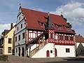
Old Town Hall, 1590

Step linden tree, 1752

Catholic parish church of
St. Peter and Paul
Longhouse 1766 to 1769


Architectural monuments
Economy and Infrastructure
Economy including agriculture and forestry
In 2017 there were 432 jobs subject to social security contributions in the municipality. Of the resident population, 1,823 people were in employment that was subject to compulsory insurance. This means that the number of out-commuters was 1,391 more than that of in-commuters. 68 residents were unemployed. In 2016 there were 24 farms.
traffic
Traffic connections
Grettstadt is about seven kilometers from the junction of Autobahn 70 No. 8 Gochsheim and No. 9 Schonungen . There is a bus line to Schweinfurt . The nearest train station is Schweinfurt Hauptbahnhof , the nearest airport is Nuremberg (100 km). Frankfurt am Main and Munich airports are 176 and 263 kilometers away, respectively.
Kitzingen-Schweinfurt railway line
At the beginning of the 20th century, Grettstadt was connected to the Bavarian railway network. In 1893 the Kitzingen- Gerolzhofen section of the so-called Steigerwaldbahn (also Lower Steigerwaldbahn) was completed. The branch line connected from 1903 Kitzingen with the Schweinfurt Hauptbahnhof and was one of the longer branch lines in Germany. Grettstadt received its own train station on the route.
Traffic on the route began to be reduced in the 1980s. From 1987 only passenger buses drove between Gerolzhofen and Schweinfurt, freight traffic was given up in mid-2006. For a long time there have been initiatives to reactivate passenger traffic on the disused route. At the beginning of 2019 a fierce dispute broke out over the design of the restart, which has continued to this day, which became a political issue .
education
There are the following institutions (as of 2018):
- Three day-care centers with 236 approved places and 208 children, 28 of them under three years of age
- Elementary school with eight classes, ten teachers and 169 students
Web links
Individual evidence
- ↑ "Data 2" sheet, Statistical Report A1200C 202041 Population of the municipalities, districts and administrative districts 1st quarter 2020 (population based on the 2011 census) ( help ).
- ↑ a b Mayor / Lord Mayor in municipalities belonging to the district (as of May 1st, 2020). (xlsx) Bavarian State Office for Statistics, accessed on June 20, 2020 .
- ↑ Grettstadt community in the local database of the Bavarian State Library Online . Bayerische Staatsbibliothek, accessed on March 6, 2018.
- ^ Comburg donation book. Sigeloch von Grettstatt hands over twelve mansus in basket to the altar of St. Nicholas in Comburg. Retrieved January 9, 2017 .
- ↑ The Free Sigeloch von Grettstadt donates 2 Hufen in Gieß (Giezzen) to the St. Stephan monastery (ad altare sancti Petri) in Würzburg. For this he should be buried in the monastery after his death. At the same time his wife Judith donated 2 hooves to the monastery in Zapfendorf (Zaffendorf), subject to lifelong usufruct. Retrieved January 9, 2017 .
- ↑ Sumaric, steady, counter-report and responsibility, on the declared and published realist Marggrave Albrechts of Brandenburg, last out, big, unupportable, ready-made disgraceful book . 1556.
- ↑ a b Grübel: Statistical Office & Address Manual for the k. bayer. Administrative district of Lower Franconia and Aschaffenburg: edited from official sources . Würzburg 1870, p. 196 ( google.de [accessed December 19, 2016]).
- ^ Wilhelm Volkert (ed.): Handbook of Bavarian offices, communities and courts 1799–1980 . CH Beck, Munich 1983, ISBN 3-406-09669-7 , p. 570 .
- ↑ a b c Federal Statistical Office (ed.): Historical municipality directory for the Federal Republic of Germany. Name, border and key number changes in municipalities, counties and administrative districts from May 27, 1970 to December 31, 1982 . W. Kohlhammer GmbH, Stuttgart / Mainz 1983, ISBN 3-17-003263-1 , p. 753 .
- ↑ Anselm Andreas Caspar Cammerer: The Kingdom of Bavaria in its current form: for schools and patriot friends . Kempten 1838, p. 288 .
- ↑ Administration> Employees> Mr. Ewald Vögler. Grettstadt community, accessed on August 4, 2020 .
- ↑ 2020 municipal council election , accessed on July 4, 2020
- ^ Story on the parish homepage , accessed on July 4, 2020
- ↑ "Stepped linden tree Grettstadt" in the tree register at www.baumkunde.de
- ↑ Graefe, Rainer, 1941-: Buildings made from living trees: guided dance and court linden trees . Geymüller, Verl. For Architecture, Aachen [a. a.] 2014, ISBN 978-3-943164-08-4 .
- ↑ mainpost.de: By train through the inner city of Schweinfurt, August 2, 2019. Accessed on January 19, 2020 .
- ↑ mainpost.de: IHK: Steigerwaldbahn would strengthen the region, July 20, 2018. Accessed on January 20, 2020 .

Bergrheinfeld | Dingolshausen | Dittelbrunn | Donnersdorf | Euerbach | Frankenwinheim | Geldersheim | Gerolzhofen | Gochsheim | Grafenrheinfeld | Grettstadt | Kolitzheim | Lülsfeld | Michelau im Steigerwald | Niederwerrn | Oberschwarzach | Poppenhausen | Röthlein | Sparing | Swan field | Schwebheim | Sennfeld | Stadtlauringen | Sulzheim | Üchtelhausen | Waigolshausen | Waterless | Werneck | Wipfeld
Unregulated areas in the district of Schweinfurt
Bürgerwald |
Geiersberg |
Hundelshausen |
Nunnery |
Stollbergerforst |
Vollburg |
Wustvieler forest