
Waterless
| coat of arms | Germany map | |
|---|---|---|

|
Coordinates: 50 ° 6 ′ N , 10 ° 2 ′ E |
|
| Basic data | ||
| State : | Bavaria | |
| Administrative region : | Lower Franconia | |
| County : | Schweinfurt | |
| Height : | 340 m above sea level NHN | |
| Area : | 51.3 km 2 | |
| Residents: | 3363 (Dec. 31, 2019) | |
| Population density : | 66 inhabitants per km 2 | |
| Postal code : | 97535 | |
| Primaries : | 09726, 09728 | |
| License plate : | SW , GEO | |
| Community key : | 09 6 78 192 | |
| Community structure: | 8 districts | |
| Address of the municipal administration: |
Kirchstrasse 1 97535 Wasserlosen |
|
| Website : | ||
| Mayor : | Anton Gößmann (OGW local community Wasserlosen) | |
| Location of the municipality Wasserlosen in the district of Schweinfurt | ||
  |
||

Wasserlosen is a municipality in the district of Schweinfurt in Lower Franconia .
geography
Wasserlosen is in the Main-Rhön region .
Community structure
Wasserlosen is divided into eight districts (also suburbs):
|
|
Neighboring communities
Neighboring communities are (starting from the north clockwise): Sulzthal , Euerbach , Geldersheim , Werneck , Arnstein , Hammelburg , Fuchsstadt and Elfershausen .
history
Until the church is planted
After secularization in 1803 in favor of Bavaria , the former office of the Hochstift Würzburg was ceded in 1805 ( Peace of Pressburg ) to Archduke Ferdinand of Tuscany to form the Grand Duchy of Würzburg and fell with him to Bavaria in 1814. In 1818 the political municipality was established.
Incorporations
On May 1, 1978, Brebersdorf, Burghausen, Greßthal, Kaisten, Rütschenhausen, Schwemmelsbach, Wasserlosen and Wülfershausen were merged into the new municipality of Wasserlosen through the municipal reform . The administrative headquarters are in Greßthal.
Population development

politics
mayor
Mayor is Anton Gößmann (OGW local community Wasserlosen). In 2014 he succeeded Günter Jakob (CSU, elected in 2002), whose predecessor was Walfried Kaufmann ( Free Voting Association ). Gößmann was elected for a further six years on March 15, 2020 with a turnout of 78.9% and 90.7% of the votes.
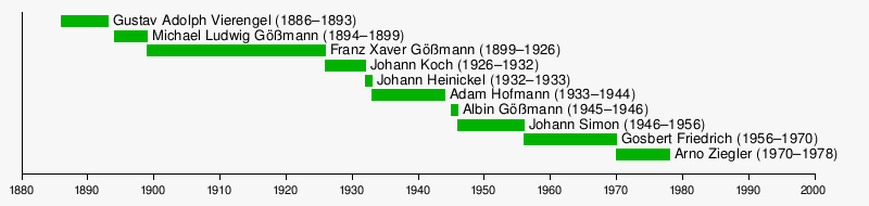
Mayor between 1886 and 1978
Finances
The 2016 budget has a volume of 7.2 million euros. 4.86 million euros go to the administrative budget and 2.34 million euros to the property budget. The main income in the administrative budget is property tax A (60,500 euros), property tax B (190,000 euros), trade tax (250,000 euros), income tax allocations (1.54 million euros) and key allocations (1.18 million euros) as well as income from administration and operations ( 1.28 million euros). The municipality's per capita debt was around 200 euros in 2015 and should be reduced to 188 euros by the end of 2016.
Inter-municipal alliance
The municipality of Wasserlosen is a member of the Intercommunal Alliance Upper Werntal and a state-recognized eco-model region.
Architectural monuments
Economy and Infrastructure
Economy including agriculture and forestry
According to official statistics, in 2014 there were four in agriculture and forestry, 37 in manufacturing and 56 in trade and transport at the place of work. In other areas of the economy 51 people were employed at the place of work subject to social security contributions. There were a total of 1460 employees at the place of residence subject to social insurance contributions. There were seven companies in the manufacturing sector and 16 companies in the construction sector. In 2013 there were also 72 farms with an agricultural area of 2791 hectares, of which 2670 hectares were arable land and 121 hectares were permanent green space.
In the Ge-los trade association, independent companies from the trades, trade, commerce and the liberal professions have come together to promote the economic development of the individual member companies through joint activities and presentations.
traffic
The A 7 ( Europastraße 45 ) with the junction (98) Wasserlosen runs through the municipality . It is affected by the A 70 and A 71 . The B 303 and the state roads 2293 and 2433 also run through the municipality.
Facilities
- Youth campground in Wülfershausen
- Dr. Maria Probst Hall in Wasserlosen
- Parish Museum Greßthal
education
In 2015 there were four kindergartens with 159 approved kindergarten places and 98 supervised children, including 31 under three years of age. In 2014, four teachers taught 75 students at the elementary school in the Wasserlosen district. The school offers extended lunchtime care under the auspices of the Ideal Association for Sports Communication and Education .
literature
- Alois Gößmann (compilation and editing), community Wasserlosen (ed.): Community Wasserlosen: with the community parts Brebersdorf, Burghausen, Greßthal, Kaisten, Rütschenhausen, Schwemmelsbach, Wasserlosen, Wülfershausen. Chronicle , Waterless: Congregation, 2014
Web links
- www.wasserlosen.de
- Entry on the coat of arms of Wasserlosen in the database of the House of Bavarian History
Individual evidence
- ↑ "Data 2" sheet, Statistical Report A1200C 202041 Population of the municipalities, districts and administrative districts 1st quarter 2020 (population based on the 2011 census) ( help ).
- ^ Community Wasserlosen in the local database of the Bavarian State Library Online . Bayerische Staatsbibliothek, accessed on December 20, 2017.
- ^ Federal Statistical Office (ed.): Historical municipality directory for the Federal Republic of Germany. Name, border and key number changes in municipalities, counties and administrative districts from May 27, 1970 to December 31, 1982 . W. Kohlhammer GmbH, Stuttgart / Mainz 1983, ISBN 3-17-003263-1 , p. 753 .
- ^ Intermunicipal alliance Upper Werntal
- ↑ Eco-model region Upper Werntal

Bergrheinfeld | Dingolshausen | Dittelbrunn | Donnersdorf | Euerbach | Frankenwinheim | Geldersheim | Gerolzhofen | Gochsheim | Grafenrheinfeld | Grettstadt | Kolitzheim | Lülsfeld | Michelau im Steigerwald | Niederwerrn | Oberschwarzach | Poppenhausen | Röthlein | Sparing | Swan field | Schwebheim | Sennfeld | Stadtlauringen | Sulzheim | Üchtelhausen | Waigolshausen | Waterless | Werneck | Wipfeld
Unregulated areas in the district of Schweinfurt
Bürgerwald |
Geiersberg |
Hundelshausen |
Nunnery |
Stollbergerforst |
Vollburg |
Wustvieler forest