Elfershausen
| coat of arms | Germany map | |
|---|---|---|

|
Coordinates: 50 ° 9 ′ N , 9 ° 58 ′ E |
|
| Basic data | ||
| State : | Bavaria | |
| Administrative region : | Lower Franconia | |
| County : | Bad Kissingen | |
| Management Community : | Elfershausen | |
| Height : | 198 m above sea level NHN | |
| Area : | 34.91 km 2 | |
| Residents: | 2794 (Dec. 31, 2019) | |
| Population density : | 80 inhabitants per km 2 | |
| Postal code : | 97725 | |
| Primaries : | 09704, 09732 | |
| License plate : | KG, BRK, HAB | |
| Community key : | 09 6 72 121 | |
| Market structure: | 6 districts | |
Market administration address : |
Marktstrasse 17 97725 Elfershausen, Germany |
|
| Website : | ||
| Mayor : | Johannes Krumm (SPD) | |
| Location of the Elfershausen market in the Bad Kissingen district | ||
Elfershausen is a market in the Lower Franconian district of Bad Kissingen and the seat of the Elfershausen administrative community . The place of the same name is also the capital.
geography
Geographical location
The community is located in the Main- Rhön region .
Community structure
There are six districts:
- Elfershausen
- Engenthal
- Langendorf
- Machtilshausen
- Trimberg
- Trimburg
There are the districts Elfershausen, Engenthal, Langendorf, Machtilshausen and Trimberg.
Surname
etymology
The name Elfershausen consists of the personal name of the local founder Adalfrid and a plural form of the Old High German basic word hûs , which means house.
Earlier spellings
Earlier spellings of the place from various historical maps and documents:
|
|
history
Until the 19th century
"Adalfrideshusom" were mentioned in a document in 780 as a donation to the Fulda monastery. The former office of the Hochstift Würzburg was left to Archduke Ferdinand of Tuscany after secularization in 1803 in favor of Bavaria in 1805 to form the Grand Duchy of Würzburg and with this in 1814 it finally fell to Bavaria.
Incorporations
- April 1, 1971: Trimberg and Engenthal
- July 1, 1971: Machtilshausen
- May 1, 1978: Langendorf
Religions
The Roman Catholic parish of Mariä Himmelfahrt Elfershausen with branches of St. Valentin Engenthal and St. Elisabeth Trimberg, the parish of St. Vitus Langendorf and the parish of St. Jakobus der Elder Machtilshausen of the diocese of Würzburg are located in the area of the municipality .
Population development
- 1961: 2599 inhabitants
- 1970: 2818 inhabitants
- 1987: 2877 inhabitants
- 1991: 2953 inhabitants
- 1995: 2903 inhabitants
- 2000: 3033 inhabitants
- 2005: 2988 inhabitants
- 2010: 2873 inhabitants
- 2015: 2822 inhabitants
politics
mayor
Johannes Krumm, nominated by the SPD and Free Voters' Association, has been mayor since May 1, 2020. He was elected in the runoff election on March 29, 2020 with 50.5% of the vote. Its predecessors were
- Karl-Heinz Kickuth (SPD) from May 2014 to April 2020 and
- Ludwig Neeb (CSU) until April 2014.
Municipal council
After the last local election on March 15, 2020 , the local council has 14 members. The turnout was 78.12%. The choice brought the following result:
- CSU : 5 seats (35.5%)
- SPD / Free Community of Voters: 4 seats (27.1%)
- New list : 3 seats (19.0%)
- Citizens' List Machtilshausen (BLM): 2 seats (18.3%)
Compared to the 2014 to 2020 term of office, the SPD / Free Voting Community and BLM each had to give up one mandate; The CSU and the new list each received a mandate to do so.
coat of arms
Current
Description of coat of arms
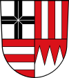
| Blazon : “Quartered; 1: a continuous black bar cross in silver; 2: two silver stakes in red; 3: Two silver bars in red; 4: three lowered silver tips in red. " | |
Coat of arms history
Elfershausen received the market rights in 1965. It was not until 1978 that the community was formed in its current size. The market community of Elfershausen was created through the amalgamation of the eponymous community of Markt Elfershausen with the formerly independent communities of Engelthal, Trimberg, Machtilshausen and Langendorf. The coats of arms of the communities of Elfershausen. Langendorf, Trimberg and Engenthal were lost through the merger. However, it was decided to adopt elements from these coats of arms in the new coat of arms. The black Fulda cross in the first field comes from the coat of arms of Langendorf. It is a reminder of the former rule of the prince monastery of Fulda in the municipality. The silver posts in red in the second field are the coat of arms of the Lords of Trimberg, which are documented until the end of the 14th century. The silver bars in red in the third field are taken from the coat of arms of Herr von Erthal. They are documented in the 12th century as feudal people of the Fulda monastery and later also of the Counts of Henneberg and the Würzburg monastery. They have been recorded in Elfershausen since 1454. The three silver tips in red in the fourth field are the coat of arms of the Hochstift Würzburg ( Franconian rake ), which, in addition to Fulda, also had rulership rights in the municipality.
- The coat of arms was awarded by the government of Lower Franconia on July 19, 1985.
Previously
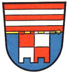
- "Divided, at the top two silver bars in red, at the bottom a notched flag in blue, square in red and silver on a gold rod at the division"
Coat of arms history
The coat of arms was awarded to the municipality in 1959. The upper half of the coat of arms is taken from the coat of arms of Herr von Erthal . They owned large estates in the municipality for many centuries. The flag in the lower part of the coat of arms indicates the rule of the Würzburg bishopric.
Architectural monuments
- St. Vitus Church Langendorf
- Trimburg
- Castle of Elfershausen
- Carpenter's house in Machtilshausen
Economy and Infrastructure
Economy including agriculture and forestry
In 1998, according to official statistics, there were 572 people in the manufacturing sector and no employees in the trade and transport sector who were subject to social security contributions at the place of work. In other economic sectors 114 people were employed at the place of work subject to social security contributions. There were a total of 1,083 employees at the place of residence subject to social security contributions. There were none in the manufacturing sector and five in the construction sector. In addition, in 1999 there were 71 farms with an agricultural area of 1430 hectares, of which 1186 hectares were arable land and 229 hectares were permanent green space.
traffic
The Elfershausen-Trimberg suburb has a connection to the Gemünden-Ebenhausen railway , which is served by the Erfurt Railway with modern diesel multiple units (“ Unterfranken-Shuttle ”) between Gemünden am Main and Schweinfurt Stadt.
education
The following institutions exist (as of: 1999):
- 123 kindergarten places with 121 children
- Johannes-Petri-Volksschule Elfershausen-Langendorf (elementary and secondary school with secondary school leaving certificate )
Web links
- [www.elfershausen.de/ Gemeindeverwaltung]
- Elfershausen: Official statistics of the LfStat
Individual evidence
- ↑ "Data 2" sheet, Statistical Report A1200C 202041 Population of the municipalities, districts and administrative districts 1st quarter 2020 (population based on the 2011 census) ( help ).
- ↑ Mayor. Elfershausen community, accessed on June 15, 2020 .
- ↑ http://www.bayerische-landesbibliothek-online.de/orte/ortssuche_action.html ? Anzeige=voll&modus=automat&tempus=+20111111/223326&attr=OBJ&val= 1565
- ↑ a b Wolf-Armin von Reitzenstein : Lexicon of Franconian place names. Origin and meaning . Upper Franconia, Middle Franconia, Lower Franconia. CH Beck, Munich 2009, ISBN 978-3-406-59131-0 , p. 63 ( limited preview in Google Book search).
- ↑ a b Wilhelm Volkert (Ed.): Handbook of the Bavarian offices, communities and courts 1799–1980 . CH Beck, Munich 1983, ISBN 3-406-09669-7 , p. 478 .
- ↑ a b c Federal Statistical Office (ed.): Historical municipality directory for the Federal Republic of Germany. Name, border and key number changes in municipalities, counties and administrative districts from May 27, 1970 to December 31, 1982 . W. Kohlhammer GmbH, Stuttgart / Mainz 1983, ISBN 3-17-003263-1 , p. 738 .
- ↑ Entry on the coat of arms of Elfershausen in the database of the House of Bavarian History


