
Your village
| coat of arms | Germany map | |
|---|---|---|

|
Coordinates: 50 ° 9 ′ N , 10 ° 1 ′ E |
|
| Basic data | ||
| State : | Bavaria | |
| Administrative region : | Lower Franconia | |
| County : | Bad Kissingen | |
| Management Community : | Your village | |
| Height : | 202 m above sea level NHN | |
| Area : | 16.34 km 2 | |
| Residents: | 1486 (Dec. 31, 2019) | |
| Population density : | 91 inhabitants per km 2 | |
| Postal code : | 97717 | |
| Area code : | 09704 | |
| License plate : | KG, BRK, HAB | |
| Community key : | 09 6 72 122 | |
| LOCODE : | DE EUF | |
| Market structure: | 2 districts | |
Market administration address : |
Zeilweg 2 97717 Euerdorf |
|
| Website : | ||
| Mayor : | Peter Bergel ( Citizens' Block ) | |
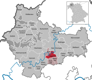
| Location of the Euerdorf market in the Bad Kissingen district | ||
  |
||

Euerdorf is a market in the Lower Franconian district of Bad Kissingen and the seat of the Euerdorf administrative association .
geography
Geographical location
The municipality is located in the Main-Rhön region in the valley of the Franconian Saale, about eight kilometers downriver from Bad Kissingen. In Euerdorf the Sulzbach (also Euerdorfer Bach) coming from a southern side valley of the Saale flows into the Franconian Saale. The historical part of the market is located south of the Saale within a partially preserved city wall , while the newer residential areas north of the Saale extend on a slope ("Breet") around which it flows. Wirmsthal, which is incorporated into Euerdorf, is three kilometers to the east, in a side valley of the Sulzbach valley.
Neighboring communities
The neighboring communities are clockwise from the north Aura an der Saale , Bad Kissingen , Ramsthal , Sulzthal and Elfershausen .
In terms of nature, the area of Euerdorf in the southeast belongs to the Wern - Lauer -Platten and in the northwest to the Südrhön ( Bavarian Rhön Nature Park ) with the border on the southeast edge of the Saale valley.
Community structure
There are two districts:
- Your village
- Wirmsthal
There are the districts of Euerdorf and Wirmsthal.
climate


The annual precipitation is 655 mm and thus falls into the lower third of all values recorded by the German Weather Service in Germany (see diagram). This may be due to the rain shading by the Rhön. The rainfall varies little over the year. The driest month is September, with most precipitation falling in June with 1.6 times that of September. Only 6% of the measuring stations in Germany register lower seasonal fluctuations and only 31% of the stations register lower annual values.
The annual mean temperature is 8.6 ° C with monthly mean values between −0.6 ° C (January) and 17.7 ° C (August) (values from the German Weather Service for neighboring Bad Kissingen).
The central parts of Euerdorf near the river are affected by floods in the Franconian Saale.
Surname
etymology
The basic word in the name Euerdorf is Old High German thorf , which means village. The defining word is probably the personal name of the local founder Uro .
Earlier spellings
Earlier spellings of the place from various historical maps and documents:
|
|
history
Until the 18th century
A first trace of the existence of a settlement in Euerdorf emerges from a document from the year 716. At that time, the Thuringian-Franconian Duke Hetan II gave the Frisian missionary Willibrord all of his possessions that belonged to him in the Saalegau near the "hamulo Castellum". St. Willibrord handed over these properties to the Echternach monastery which he founded . In 907 the Echternach monastery exchanged its possessions in the Saale valley with the Fulda monastery . The document from 716 in connection with this one from the year 907 provides with the content and the interpretation essential knowledge about the history of Euerdorf.


Euerdorf has had market rights since 1430 . In 1494 the Willibrords Chapel was mentioned in a document in the municipality's cemetery. At the time of the Würzburg prince-bishop Julius Echter von Mespelbrunn (1573-1617), the market town was surrounded by a circular wall with three gates, of which parts of the wall with a defensive tower and the upper gatehouse are still preserved. Today's Ringstrasse follows the course of this wall. In their place there used to be a ditch.
19th to 21st century
In the secularization of 1803 the former office of the Hochstift Würzburg, which belonged to the Franconian Empire , fell to Bavaria, but in 1805 it left it to Archduke Ferdinand of Tuscany in exchange for Tyrol to form the Grand Duchy of Würzburg . In 1814 it finally came to Bavaria and became the Lower Main District (today Lower Franconia).
In the period from 1802 to 1804 a regional court and the rent office were created in Euerdorf, both of which belonged to 24 towns. The district court was called from 1880 district court and was repealed in 1925 and added to the jurisdiction of the district court Hammelburg

The Catholic parish church of St. Johann Baptist (St. John the Baptist) dates from 1602. After a fire on September 15, 1872, it was rebuilt in the late Gothic style and expanded between 1974 and 1977. Today Euerdorf with Aura, Ramsthal, Sulzthal and Wirmsthal belongs to the parish community of Saalethal.
In 1924 Euerdorf received a railway connection by closing the gap in the Franconian Saale Valley Railway between Hammelburg and Bad Kissingen.
After the Second World War, construction activity in Euerdorf was limited to the south side of the hall until 1964. After that, the development was carried out, especially on the northern side, in a loosened-up style of construction in contrast to the small-scale, closed-off historical part.
At the beginning of June 2011, the geotope dinosaur tracks Euerdorf am Saalrangen in Euerdorf was officially included (No. 98) in the 100 most beautiful geotopes in Bavaria by the Bavarian State Office for the Environment. These are archosaur footprints and dinosaur precursors that were found in 2007 during clean-up work after Hurricane Kyrill .
On 25 October 2013 the market Euerdorf by the Bavarian Minister of Agriculture was Helmut Brunner the Bavarian State Prize 2013 - village renewal and building culture for the project Terra Triassica awarded.
Incorporations
On May 1, 1978, as part of the municipal reform, the municipality of Wirmsthal was incorporated into the Euerdorf market and at the same time an administrative community consisting of the municipalities of Aura an der Saale, Euerdorf, Ramsthal and Sulzthal was founded, the seat of which is Euerdorf.
Population development
| year | 1961 | 1970 | 1980 | 1985 | 1990 | 1995 | 2000 | 2005 | 2010 | 2015 |
| Residents | 1,463 | 1,543 | 1,478 | 1,523 | 1,656 | 1,822 | 1,677 | 1,641 | 1,575 | 1,498 |
The Wirmsthal district accounts for around 26%.
politics
Municipal council
After the last local election on March 15, 2020, the local council has twelve members. The choice brought the following result:
| CSU / Free Voting Community | 4 seats | ||
| Civic bloc | 6 seats | ||
| Free voter community Wirmsthal | 3 seats |
mayor
Peter Bergel (Bürgerblock) has been mayor since May 1, 2020; he was elected with a voter turnout of 72.0% on March 15, 2020 with 66.7% of the vote. Its predecessors were
- Patricia Schießer (CSU / Free Voting Community) from 2014 to 2020 and
- Reinhard Hallhuber (CSU / Free Voting Community) until 2014.
coat of arms
|
|
Blazon : "In silver on a green three-hill side by side, two vines on red stakes with two golden grapes and two green leaves each."
The coat of arms in its current design was awarded on April 20, 1959. |
Coat of arms history: the oldest known seal dates from 1650 and already shows four grapes. Viticulture was of great importance at that time. But since then it has gradually become insignificant. The seal is inscribed “S. Marckt Ewerdorf an der Sal ”. The Lamb of God with the Easter flag is arranged on the upper edge of the shield. In the 19th century, the grapes were completely replaced by the Lamb of God. It was not until the end of the 19th century that the grapes were shown in the coat of arms again.
Attractions


- Old Saale Bridge
- An eight-arched stone bridge along the former road from Euerdorf to Bad Kissingen leads over the Franconian Saale. The oldest parts date from the 16th century. The bridge was enlarged around 1740 and completely renovated in 1992/93. On the bridge there is a statue of St. Nepomuk from 1713.
- Gatehouse
- The gatehouse is the last preserved of the three former gate towers in the course of the city wall from the time of Bishop Julius Echter von Mespelbrunn (1573-1617) on Kissinger Straße. The three-storey building with stepped gables is called Torhaus because of the gatekeeper's apartment inside .
- Built the permanent exhibition of the museum in 1598 as the official home of the Würzburg cathedral chapter and used as a hunting lodge former old forester's house (from 1885) of Euerdorf shows fossils which change the Triassic Life world from 252.5 to 201.5 million years ago in what is now Main franc show . It explains the changes in the environmental conditions in this area, the animals and plants living here, their extinction or new emergence, and their life in their ecosystems .
- Former tithe house
- The tithe house near the gatehouse is a solid building with a stepped gable from the 16th century. It was used to collect and store the tithe to be paid to the church . Because of the earlier viticulture and the resulting tithe delivery in the form of grapes, it was also known as the Domkapitel cellar. It is now a residential building.
- Gasthof Zum Lamm
- The inn on Schweinfurter Strasse is a three-story building with stepped gables. The upper floor is made of timber framing. The house was named as early as 1595 and was formerly the community inn. In 1781 it was sold to private hands.
- The Euerdorfer parish church on Hammelburger Straße is a Gothic building. The first building was from 1602. After a fire in 1872 the church was rebuilt. During the last restoration in 1974 it was completely redesigned and expanded.
- Willibrord Chapel
- The chapel is a simple building from 1868 in the local cemetery. It is particularly important because of the previous building, which was mentioned as early as 1494 and also served as a pilgrimage destination.
- It is dedicated to St. John the Baptist. The current building is classicistic and dates from 1823. The last renovation was from 1971 to 1973. Some of the furnishings of the church can be assigned to the 17th century.
- Retirement home (family home)
- The house on Schweinfurter Strasse is a building with ornamental gables and sandstone structures from 1902. The old people's home was created for his home town from a foundation by the businessman Michael Josef Philippi.
- Gargoyles
- On a residential building on the market square with a decorative framework from the 18th century, there are gargoyles that are unusual for a residential building .
- Geological experience point and geotope dinosaur tracks Euerdorf
- In the red sandstone (originating 240–250 million years ago) at the Saalrangen in Euerdorf, a rock layer with the footprints of archosaurs and dinosaur precursors was exposed. The Bavarian State Office for the Environment named the Euerdorf dinosaur tracks one of the 100 most beautiful geotopes in Bavaria in 2011. Nowhere else in Bavaria can you see dinosaur tracks on such a large area.
- Geological experience point and geotope Wichtelhöhlen
- On the “Alten Euerdorfer Straße” there is a larger outcrop (area 15,000 m²) in the red sandstone in the area of the Saale impact slope “Batzenleite”. There are blocks of stone up to ten meters in size. Gaps and cavities between the blocks represent the legendary "Wichtelhöhlen".
Economy and Infrastructure
economy

The municipal tax revenue amounted to 1,511,000 euros in 2007, of which business tax revenue (net) was 856,000 euros.
According to the official statistics from 2007, there were 505 employees subject to social security contributions with Euerdorf as their place of work, of which 246 were employed in a manufacturing industry and 169 in other services. There were 3 companies in the manufacturing sector with more than 20 employees, in which a total of 216 people were employed. For example, you work in the areas of wear protection and automatic lubrication technology.
The agriculturally used area amounts to almost 600 hectares (577 in 1999), of which approx. 85% is arable land and 12% is permanent green area. Wirmsthal is Franconia's northernmost wine-growing region.
In a former quarry above Wirmsthal is the garbage dump of the Bad Kissingen district with a protection of the surrounding area through a modern multi-barrier concept (double sealing).
traffic
The place Euerdorf has a stop on the Franconian Saale Valley Railway from Gemünden am Main to Bad Kissingen. The Lower Franconia shuttles of the Erfurt Railway run from / to Schweinfurt city every hour (with gaps in the intervals) . In addition, several bus lines stop in Euerdorf.
Euerdorf is located on the federal highway 287 , via which the A7 motorway can be reached at a distance of 5 km .
education
The following institutions exist (as of 2009):
- Kindergarten Paradieso with 75 places
- Einhard elementary school Euerdorf (elementary and secondary school) with approx. 310 students and approx. 15 teachers
Web links
- www.euerdorf.de
- Dinosaur tracks in your village
- Euerdorf: Official statistics of the LfStat
- Euerdorf in the Bavaria database
Individual evidence
- ↑ "Data 2" sheet, Statistical Report A1200C 202041 Population of the municipalities, districts and administrative districts 1st quarter 2020 (population based on the 2011 census) ( help ).
- ↑ Mayor. Municipality of Euerdorf, accessed on June 28, 2020 .
- ↑ http://www.bayerische-landesbibliothek-online.de/orte/ortssuche_action.html ? Anzeige=voll&modus=automat&tempus=+20111111/223805&attr=OBJ&val= 1566
- ^ Average temperatures of the DWD for 1961–1990
- ↑ Flood in Euerdorf ( Memento of the original from March 24, 2009 in the Internet Archive ) Info: The archive link was inserted automatically and has not yet been checked. Please check the original and archive link according to the instructions and then remove this notice.
- ↑ a b Wolf-Armin von Reitzenstein : Lexicon of Franconian place names. Origin and meaning . Upper Franconia, Middle Franconia, Lower Franconia. CH Beck, Munich 2009, ISBN 978-3-406-59131-0 , p. 68 ( limited preview in Google Book search).
- ^ Günter H. Wich: Brückenau - Hammelburg . Ed .: Commission for Bavarian State History. Munich 1973, ISBN 3-7696-9881-9 , pp. 13.14 .
- ↑ "Euerdorf owes Kyrill a geotope" - article in the " Saale-Zeitung " from June 1st, 2011
- ↑ Laureate State Prize 2013 ( Memento of the original from February 1, 2014 in the Internet Archive ) Info: The archive link was inserted automatically and has not yet been checked. Please check the original and archive link according to the instructions and then remove this notice.
- ↑ a b Federal Statistical Office (ed.): Historical municipality register for the Federal Republic of Germany. Name, border and key number changes in municipalities, counties and administrative districts from May 27, 1970 to December 31, 1982 . W. Kohlhammer GmbH, Stuttgart / Mainz 1983, ISBN 3-17-003263-1 , p. 739 .
- ↑ Population figures in Bad Kissingen ( page no longer available , search in web archives ) Info: The link was automatically marked as defective. Please check the link according to the instructions and then remove this notice. (PDF; 10 kB)
- ↑ Entry on the coat of arms of Euerdorf in the database of the House of Bavarian History
- ↑ Municipal data 2008 of the Bavarian State Office for Statistics and Data Processing
- ↑ Wirmsthal landfill (PDF; 1 MB)

Aura on the Saale | Bad Bocklet | Bad Brueckenau | Bad Kissingen | Burkardroth | Elfershausen | Your village | Fuchsstadt | Geroda | Hammelburg | Maßbach | Moths | Münnerstadt | Nüdlingen | Oberleichtersbach | Oberthulba | Oerlenbach | Ramsthal | Rannungen | Riedenberg | Schondra | Sulzthal | Thundorf in Lower Franconia | Wartmannsroth | Wild spots | Zeitlofs
Unregulated areas of
Dreistelzer Forst |
Forst Detter-Süd |
Geiersnest-East |
Geiersnest-West |
Great Auersberg |
Calf Hill |
Motten Forest South |
Neuwirtshauser Forest |
Omerz and Red Mountain |
Römershager Forest North |
Römershager Forest East |
Rossbach Forest |
Waldfensterer forest