Ramsthal
| coat of arms | Germany map | |
|---|---|---|

|
Coordinates: 50 ° 8 ' N , 10 ° 4' E |
|
| Basic data | ||
| State : | Bavaria | |
| Administrative region : | Lower Franconia | |
| County : | Bad Kissingen | |
| Management Community : | Your village | |
| Height : | 252 m above sea level NHN | |
| Area : | 10.42 km 2 | |
| Residents: | 1121 (Dec. 31, 2019) | |
| Population density : | 108 inhabitants per km 2 | |
| Postal code : | 97729 | |
| Area code : | 09704 | |
| License plate : | KG, BRK, HAB | |
| Community key : | 09 6 72 142 | |
| LOCODE : | DE VM7 | |
| Community structure: | 1 district | |
| Association administration address: | Zeilweg 2 97717 Euerdorf |
|
| Website : | ||
| Mayor : | Rainer Morper (active citizens' block and IG Ramsthal) | |
| Location of the municipality of Ramsthal in the Bad Kissingen district | ||
Ramsthal is a municipality and a wine village in the Lower Franconian district of Bad Kissingen and a member of the Euerdorf administrative community .
geography
The wine village is located in a side valley of the Franconian Saale , near the spa town of Bad Kissingen . To the south-east of the district there is a dissolved shell limestone quarry that is today a geotope .
Surname
etymology
The basic word in the name Ramsthal is the Middle High German word tal , which means valley . Two possible theories are mentioned to explain the determinant:
- Possibly the contracted form of the old personal name Rhaban is in the place name. The explanation is the Valley of the Rhaban .
- The Middle High German genitive forms of aries or rams ( wild garlic ) could also be considered. As an explanation, Widdertal or Bärlauchtal would result.
Earlier spellings
Earlier spellings of the place from various historical maps and documents:
- 1150 "Ramestal"
- 1386 "Ramstal"
- 1412 "Ramsthal"
history
Until the church is planted
The former office of the Hochstift Würzburg , which belonged to the Franconian Empire , was left to Archduke Ferdinand of Tuscany to form the Grand Duchy of Würzburg after secularization in 1803 in favor of Bavaria in 1805 , and with this in 1814 it finally fell to Bavaria . In the course of the administrative reforms in Bavaria, today's municipality was created with the municipal edict of 1818 .
Population development
- 1961: 972 inhabitants
- 1970: 1116 inhabitants
- 1987: 1105 inhabitants
- 1991: 1106 inhabitants
- 1995: 1148 inhabitants
- 2000: 1160 inhabitants
- 2005: 1201 inhabitants
- 2010: 1163 inhabitants
- 2015: 1093 inhabitants
- 2016: 1098 inhabitants
politics
mayor
Rainer Morper (Active Citizens' Block and Interest Group Ramsthal) has been Mayor since May 1, 2020; he was elected in the runoff election on March 15, 2020 with 52.1% of the vote. His predecessor was Alfred Gündling (CSU) from May 2014 to April 2020.
Municipal council
The 2020 local elections resulted in the following occupation in the local council:
- CSU : 4 seats
- Active civic block and community of interests Ramsthal : 6 seats
- Ramsthaler list: 2 seats
coat of arms
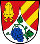
Blazon : “In red a curled silver tip, inside a blue grape with green leaves; in front a golden miter, behind two golden oblique left bars. "
Coat of arms history: The importance of viticulture in the municipality is symbolized in the coat of arms by the blue grape. The golden miter indicates the Benedictine monastery Aura an der Saale, which was founded in the 11th century by Bishop Otto von Bamberg and dissolved again in 1564. The community was first mentioned in 1122 in connection with a donation to this monastery. The sloping beams come from the coat of arms of Herr von Hutten, they had rulership rights in the municipality between the 15th and 17th centuries. The coat of arms was awarded by the government of Lower Franconia on June 23, 1971.
Architectural monuments
Economy and Infrastructure
In 2017, the municipal tax revenue was 750,000 euros, of which 125,000 euros were trade tax revenue (net) and 520,000 euros were income tax participation.
Economy including agriculture and forestry
In 2017 there were 59 jobs subject to social security contributions in the municipality. Of the resident population, 469 people were in an employment relationship subject to compulsory insurance. The number of out-commuters was 410 more than that of in-commuters. 16 residents were unemployed. In 2016 there were 14 farms. Viticulture is also important for Ramsthal, as it attracts a large number of guests to the community.
education
There is the following institution (as of 2018):
- A day-care center for children with 50 places and 34 supervised children
There are no elementary or secondary schools in the municipality.
Individual evidence
- ↑ "Data 2" sheet, Statistical Report A1200C 202041 Population of the municipalities, districts and administrative districts 1st quarter 2020 (population based on the 2011 census) ( help ).
- ↑ a b c d Wolf-Armin von Reitzenstein : Lexicon of Franconian place names. Origin and meaning . Upper Franconia, Middle Franconia, Lower Franconia. CH Beck, Munich 2009, ISBN 978-3-406-59131-0 , p. 182 ( limited preview in Google Book search).
- ↑ Announcement of the municipal council election results , accessed on June 23, 2020
Web links
- Entry on the Ramsthal coat of arms in the database of the House of Bavarian History


