Former shell limestone quarry southeast of Ramsthal
|
Former Muschelkalkbruch SÖ from Ramsthal
|
||
|
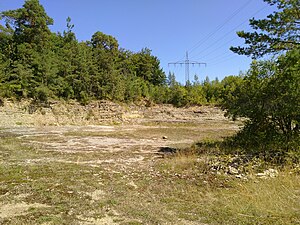
Overview of the former Muschelkalkbruch. |
||
| location | Ramsthal , Lower Franconia , Bavaria , Germany | |
| surface | 600sqm | |
| Identifier | Geotope 672A021 | |
| Geographical location | 50 ° 8 ' N , 10 ° 5' E | |
|
|
||
| Sea level | from 350 m to 353 m | |
The former limestone fraction southeast of Ramsthal is a geological site in the district of Ramsthal in the Lower Franconian district of Bad Kissingen . In the shell there are fossils and sedimentary geodes from the Middle Triassic , from approximately 247.2 to about 235 million years ago.
description
The abandoned quarry is located in the southeast of the Ramsthal municipality 350 m above sea level. NHN and is about 30 m long, 20 m wide and 3 m high. The rocks come from the geological spatial unit of the western Franconian plates . The Bavarian State Office for the Environment classifies the area as a geotope with the number 672A021. Neighboring geotopes are the former Muschelkalkbruch southwest of Krautheim and the former Muschelkalkbruch south-southwest of Dettelbach .
Find opportunities
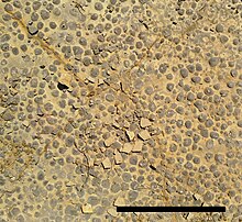
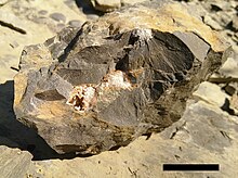
There is wave limestone , a foam limestone bank with a stromatolithic character and orbicularis layers with their key fossil , numerous pavements of the round mussel Neoschizodus orbicularis . The rocks belong to the Lower and Middle Muschelkalk .
There are opportunities to find fossils.
The geotope is also home to some endangered species, such as the silver thistle .
Development
The quarry is significant as an excursion, research and teaching object. The general geoscientific significance is valuable.
Individual evidence
- ↑ a b State Office for the Environment (Ed.): Former. Muschelkalkbruch SÖ from Ramsthal , accessed on August 6, 2018.
- ↑ M. Henz, B. Neubig and J. Sell: Der Untere Muschelkalk von Unterfranken. A contribution from the Mainfränkische Trias Euerdorf collection.
- ↑ A. Müller, G. Beutler and S. Siegesmund: Geologie des Triaslandes und Landschaftsentwicklung In: S. Siegesmund, M. Hoppert and K. Epperlein (eds.): "Nature | Stone | Culture | Wine: Between Saale and Unstrut ”, ISBN 978-3-95462-293-1 Mitteldeutscher Verlag, Halle / Saale (2014).


