
Oberschwarzach
| coat of arms | Germany map | |
|---|---|---|

|
Coordinates: 49 ° 52 ' N , 10 ° 25' E |
|
| Basic data | ||
| State : | Bavaria | |
| Administrative region : | Lower Franconia | |
| County : | Schweinfurt | |
| Management Community : | Gerolzhofen | |
| Height : | 278 m above sea level NHN | |
| Area : | 25.51 km 2 | |
| Residents: | 1422 (Dec. 31, 2019) | |
| Population density : | 56 inhabitants per km 2 | |
| Postal code : | 97516 | |
| Area code : | 09382 | |
| License plate : | SW , GEO | |
| Community key : | 09 6 78 164 | |
| Market structure: | 12 districts | |
| Association administration address: | Brunnengasse 5 97447 Gerolzhofen |
|
| Website : | ||
| Mayor : | Manfred Schötz ( Breitbach / Kammerforst community of voters ) | |
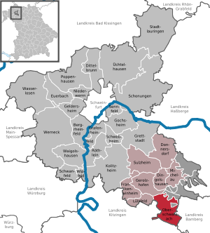
| Location of the Oberschwarzach market in the Schweinfurt district | ||
  |
||

Oberschwarzach is a market in the Lower Franconian district of Schweinfurt and a member of the Gerolzhofen administrative community .

geography
Oberschwarzach is located in the Main-Rhön region .
Community structure
Oberschwarzach is divided into twelve districts:
|
|
There are the districts Breitbach, Handthal, Mutzenroth, Siegendorf, Wiebelsberg, Oberschwarzach, Düttingsfeld and Schönaich.
Neighboring communities
Neighboring communities are (starting from the north clockwise): Ebrach , Geiselwind , Prichsenstadt , Lülsfeld and Gerolzhofen .
history
Until the church is planted
The former office of the Hochstift Würzburg , which from 1500 belonged to the Franconian Empire , was left to Archduke Ferdinand of Tuscany to form the Grand Duchy of Würzburg after the secularization in 1803 in favor of Bavaria in 1805 , and with this in 1814 it finally fell to Bavaria . In the course of the administrative reforms in Bavaria, today's municipality was created with the municipal edict of 1818 .
Incorporations
On January 1, 1971, the previously independent municipality of Mutzenroth was incorporated. Wiebelsberg was added on July 1, 1972. Breitbach, Handthal and Siegendorf followed on May 1, 1978.
Population development

politics
Manfred Schötz (Voting Community Breitbach / Kammerforst) has been mayor since May 1, 2014; he was re-elected on March 15, 2020 with a voter turnout of 77.9% with 65.5% of the votes.
Culture and sights


- The Erich Kästner Library owns the entire inventory from the legacy of the writer Erich Kästner . The Erich Kästner Kinderdorf e. V.
Buildings
- Parish church Peter and Paul with Madonna and Child from the 15th century and Saint Sebastian from the workshop of Tilman Riemenschneider
- Marian column
- Oberschwarzach Castle, built in 1614 by the Würzburg Prince-Bishop Julius Echter
- Stollburg castle ruins on the Stollberg, Germany's steepest vineyard with a gradient of up to 70%, in the Handthal district. The castle was possibly the birthplace of Walther von der Vogelweide .
- Pentagonal vineyard chapel from 1981 14 holy helpers with tent roof - a campanile next to the winegrower's chapel
Architectural monuments
Economy and Infrastructure
Economy including agriculture and forestry
According to official statistics, there were three employees at the place of work in the field of agriculture and forestry, 60 in the manufacturing sector and 24 in trade and transport. In other economic areas, 28 people were employed at the place of work subject to social security contributions. There were a total of 489 employees at the place of residence subject to social security contributions. There were three companies in the manufacturing sector and two in the construction sector. In addition, in 1999 there were 94 farms with an agricultural area of 1374 hectares, of which 1072 hectares were arable land and 216 hectares were permanent green space.
traffic
The district Breitbach is crossed by the federal road 22 .
education
The following institutions exist (as of: 1999):
- 75 places in kindergarten with 73 children
- an elementary school with 13 teachers and 244 students
- School location of the secondary school I Gerolzhofen (5th and 6th grade)
Personalities
- Ludwig Ludwig (* 1640, † 1696), born in Oberschwarzach, Cistercian abbot of the Ebrach monastery
- Josef August Eichelsbacher (* 1884, † 1968), born in Oberschwarzach, school councilor i. R .; Eichelsbacher wrote many books about the local history of the Kahlgrund and Lower Franconia.
- Georg Häfner (* 1900, † 1942), Catholic pastor in Oberschwarzach, was a staunch opponent of the Nazi regime and was killed in the Dachau concentration camp .
Web links
- Entry on the coat of arms of Oberschwarzach in the database of the House of Bavarian History
Individual evidence
- ↑ "Data 2" sheet, Statistical Report A1200C 202041 Population of the municipalities, districts and administrative districts 1st quarter 2020 (population based on the 2011 census) ( help ).
- ↑ http://www.bayerische-landesbibliothek-online.de/orte/ortssuche_action.html ? Anzeige=voll&modus=automat&tempus=+20111114/220444&attr=OBJ&val= 1766
- ^ Wilhelm Volkert (ed.): Handbook of Bavarian offices, communities and courts 1799–1980 . CH Beck, Munich 1983, ISBN 3-406-09669-7 , p. 471 .
- ^ Federal Statistical Office (ed.): Historical municipality directory for the Federal Republic of Germany. Name, border and key number changes in municipalities, counties and administrative districts from May 27, 1970 to December 31, 1982 . W. Kohlhammer GmbH, Stuttgart / Mainz 1983, ISBN 3-17-003263-1 , p. 754 .
- ↑ Tourism magazine Fränkisches Weinland No. 05/11
- ↑ Main-Post (January 24, 2010): Was Walther von der Vogelweide a real Franconian?

Bergrheinfeld | Dingolshausen | Dittelbrunn | Donnersdorf | Euerbach | Frankenwinheim | Geldersheim | Gerolzhofen | Gochsheim | Grafenrheinfeld | Grettstadt | Kolitzheim | Lülsfeld | Michelau im Steigerwald | Niederwerrn | Oberschwarzach | Poppenhausen | Röthlein | Sparing | Swan field | Schwebheim | Sennfeld | Stadtlauringen | Sulzheim | Üchtelhausen | Waigolshausen | Waterless | Werneck | Wipfeld
Unregulated areas in the district of Schweinfurt
Bürgerwald |
Geiersberg |
Hundelshausen |
Nunnery |
Stollbergerforst |
Vollburg |
Wustvieler forest