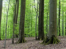
Wustvieler forest

The Wustvieler Forst is an 8.49 km² community-free area in the Lower Franconian district of Schweinfurt in the Steigerwald . The area is completely forested .
location
The Wustvieler forest is north of the community Rauhenebrach with the eponymous district Wustviel. The highest point in the community-free area is an unnamed mountain at 473 m above sea level. NN . The origin of the Rauhen Ebrach lies in the Wustvieler forest .
Culture and sights
The Kleinengelein forest area, a former forest training forest approx. Two square kilometers in size, which is no longer used for forestry purposes. As part of the discussion about the designation of a national park in the northern Steigerwald, an area of 53.7 ha was placed under protection as a natural forest reserve in 2010 .
Neighboring communities
|
Hundelshausen (municipality-free area) |
||
| municipality Michelau |

|
|
| Community Rauhenebrach |
See also
Individual evidence
- ↑ http://www.pro-nationalpark-steigerwald.de/
- ↑ http://www.naturwaelder.de/index.php?tpl=detail&id_nwr=2459
Web links
- Community-free area Wustvieler Forst in OpenStreetMap (accessed on August 28, 2017)
Coordinates: 49 ° 54 ′ 45.2 ″ N , 10 ° 29 ′ 23 ″ E

