
Gerolzhofen
| coat of arms | Germany map | |
|---|---|---|

|
Coordinates: 49 ° 54 ' N , 10 ° 21' E |
|
| Basic data | ||
| State : | Bavaria | |
| Administrative region : | Lower Franconia | |
| County : | Schweinfurt | |
| Management Community : | Gerolzhofen | |
| Height : | 244 m above sea level NHN | |
| Area : | 18.39 km 2 | |
| Residents: | 6868 (Dec. 31, 2019) | |
| Population density : | 373 inhabitants per km 2 | |
| Postal code : | 97447 | |
| Area code : | 09382 | |
| License plate : | SW , GEO | |
| Community key : | 09 6 78 134 | |
| City structure: | 4 districts | |
City administration address : |
Brunnengasse 5 97447 Gerolzhofen |
|
| Website : | ||
| Mayor : | Thorsten Wozniak ( CSU ) | |
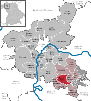
| Location of the city of Gerolzhofen in the district of Schweinfurt | ||
  |
||

Gerolzhofen is a town in the Lower Franconian district of Schweinfurt and the seat of the Gerolzhofen administrative community . The former district town of the Gerolzhofen district, which was dissolved in 1972, is designated as a middle center and the only town in the Schweinfurt district, but only the fifth largest municipality in terms of inhabitants. The four larger communities are all in the Schweinfurt metropolitan area , but the city of Gerolzhofen is the most populous old town in the district.
geography
Geographical location
The city is located on the northwestern edge of the Steigerwald in the natural area of the Steigerwald foreland about 18 kilometers southeast of Schweinfurt . The climate is temperate, due to the slight accumulation of the Steigerwald, the Gerolzhöfer area has an annual rainfall of around 650 mm, while in the neighboring Schweinfurt basin there is up to 100 mm less rainfall per year. Due to continental influences, hot summers with up to 35 ° Celsius during the day are possible, often relatively dry, but interrupted by occasional quite violent thunderstorms with heavy rain events. Cold winters with a rather thin layer of snow but often well below minus 10 ° Celsius can also be observed in the nights.
Neighboring communities
Neighboring communities are (starting from the north clockwise): Sulzheim , Dingolshausen , Oberschwarzach , Frankenwinheim and Lülsfeld .
City structure
There are four parts of the city:
- Gerolzhofen
- Klesenmühle
- Lindelachshof
- Rügshofen

history
Until the church is planted
From prehistoric times, a settlement farm of the Großromstedt culture was excavated in 1994 , which was probably part of an agricultural scattered settlement and in which various ceramic vessels were found. The farm consisted of a 14-meter-long stable house , a storehouse standing on stilts to protect what was stored in it, and a pit house probably used for wool processing . A baking oven, a lime kiln, a clay pit and a storage pit for food to be kept cool were also found in the vicinity of these buildings.
Settlement in Gerolzhofen
The Gerolzhofen settlement was first mentioned between 750 and 779 in a later copy (12th century) of a deed of donation from the Fulda monastery . The name giver is Gerold II from Udalrichingen . The fortified town became a town in the second half of the 13th century from an Ebrach document in which it was mentioned in 1296 as an " oppidum ". In 1345 Gerolzhofen was first mentioned as a "city" when a wine market was moved from Dingolshausen. Between 1500 and 1806 the city was part of the Franconian Empire .
In the second half of the 16th century, more than half of the city's population was Protestant . However, due to the rigid religious and political approach of Würzburg Bishop Julius Echter von Mespelbrunn , the year 1586 was a turning point in Gerolzhofen’s denominational history: the vast majority of townspeople either became Catholics or left the town. Since then, Gerolzhofen can be considered a Catholic city. Today there is again a small Protestant community in the Erlöserkirche on the edge of the old town.
In 1631 the neighboring village of Lindelach was destroyed by Swedish troops. The local population moved to Gerolzhofen and formed an independent community there from 1818.
Witch trials in Gerolzhofen
Under the government of the Würzburg Prince-Bishop Philipp Adolf von Ehrenberg , over 900 people accused of witchcraft died from execution and torture . In the Würzburg ischen Gerolzhofen was a main court. From 1615 to 1619, 261 people were executed for witchcraft. Many died before being sentenced as a result of torture in the witches' tower and Cent prison.
At the time of witch hunts were in Gerolzhofen pyre built for burning of most of the condemned. At times, so many people became victims of the witch trials that the economy was seriously jeopardized.
Municipal reorganization
In the course of the municipal reorganization of Bavaria , the district of Gerolzhofen was dissolved on July 1, 1972 and the city lost the status of a district town . On 1 January 1978, the neighboring village Rügshofen was within the framework of administrative reform in Bavaria incorporated .
politics
City council
After the local elections on March 2, 2008 , the 20 seats of the city council are distributed among the individual groups as follows:
| Party / list | CSU | SPD | FW | REP | geo-net. | The young | total |
|---|---|---|---|---|---|---|---|
| Seats | 8 seats | 4 seats | 5 seats | 1 seat | 1 seat | 1 seat | 20 seats |
After the local elections on March 16, 2014 , the 20 seats of the city council are distributed among the individual groups as follows:
| Party / list | CSU | SPD | FW | geo-net. | The young | Citizens for GEO | total |
|---|---|---|---|---|---|---|---|
| Seats | 7 seats | 4 seats | 4 seats | 3 seats | 1 seat | 1 seat | 20 seats |
In the city council election on March 15, 2020 , the four nominations received the following city council seats and voting shares:
| Party / list | CSU | SPD | FW | geo-net. [1] | total |
|---|---|---|---|---|---|
| Seats | 7 seats | 4 seats | 5 seats | 4 seats | 20 seats |
| Share of votes | 33.71% | 20.17% | 28.08% | 18.04% | 100.00% |
mayor
The first mayor has been Thorsten Wozniak (CSU) since February 1, 2013, who won the runoff election on October 7, 2012 with 60.3 percent against the incumbent Irmgard Krammer (Free Voters). Wozniak was elected for another six years on March 15, 2020 with 84.1% of the vote.
coat of arms
|
|
Blazon : "Three shortened silver tips in red." |
Town twinning
Gerolzhofen maintains city partnerships
-
 Mamers in France , Sarthe department , since 1972
-
 Elek in Hungary , Békés county , since 2008
In addition, there are friendly relationships with
Sponsorship
- In 1992 the sponsorship for the expelled Sudeten Germans from the city and the district of Bilin was taken over.
Culture and sights

Museums
- City museum in the old town hall with permanent exhibition From poor little tailor to clothes factory - world success sewing machine . Development of sewing linked to the local history of Gerolzhofen. Other departments: Originally furnished classroom with an exhibition of objects related to the lessons. Collection of exhibits of popular piety, household and yard tools and various tools from the city.
- Museum Johanniskapelle Art and Spirit of the Gothic (see cemetery chapel)
Buildings
church


The Catholic parish church of Saint Mary of the Rosary and Saint Regiswindis , also known as the Steigerwald Cathedral, was built between 1436 and 1479. The interior shows a baroque Maria in a halo surrounded by a double rosary, the crown of which is held by two late Gothic angels from the Riemenschneider School . The high altar (around 1764) by the Würzburg court sculptor Johann Peter Wagner and the altarpiece of the Coronation of Mary by the Würzburg court painter Christoph Fesel adorn the nave of the church. The side altars of the tower chapels are also by Johann Peter Wagner. In addition, there is an octagonal pulpit (1705/06) with late Gothic wooden figures of the four evangelists and Christ Salvator in the niches, as well as a Madonna and Child on the sound cover from the same period. In the south aisle, glass paintings from the construction period of the church adorn the interior as an iconographic feature: a Mother of God with a child and the representation of the church building with construction workers, marketplace and surrounding wall .
Further
- Former two-storey cemetery chapel with karner , built from 1497; Today the Museum Johanniskapelle Kunst und Geist der Gotik with adjoining Baroque sacristan house , set up and designed by the art department of the Diocese of Würzburg, sponsored by the city of Gerolzhofen, with numerous works from the city and parish as well as the diocese's art collections, including sculptures by Tilmann Riemenschneider and his workshop
- Old Town Hall, built in 1475; distinctive three-storey building with Gothic stepped gables, used as a city museum since 1984
- Marketplace with modern market fountain
- City fortifications with double wall ring, several corner towers of the outer fortifications, white tower and owl or witch tower of the inner ring
- Former Oberamtshaus, Renaissance building with scroll gables , built in 1580 by Prince-Bishop Julius Echter , today the seat of the administrative association
- Citizen's Hospital with St. Vitus Hospital Church, donated in 1402
- Jewish cemetery from 1639
Architectural monuments
Recreational facilities
- General dog club Gerolzhofen
- Geomaris leisure pool
- Sauna garden run by the Röder family sauna company (Dreimühlenstrasse 29)
- Takka-Tukka Adventure Land
- Fitness trail Gerolzhofen
- Gerolzhofen model airfield
- Kart track Steigerwald-Motodrom Gerolzhofen
- Youth center / youth center Gerolzhofen
- Gerolzhofen amusement park ( skater area , pump track , streetball field and calisthenics facility)
Regular events
- Spring Festival (March)
- Asparagus and Wine Market (April)
- Vineyard hike and wine festival in the countryside at the Gertraudiskapelle (May 1st)
- Gerolzhöfer Culture Days (May)
- Gerolzhöfer Health Days (June)
- Art and culinary delights ("Alleefest") (June)
- Shooting Festival (July)
- Steigerwald regional wine festival on the market square ( Franconia's largest wine bar , July)
- Geo live Night , the Gerolzhöfer pub festival
- Autumn Festival (October)
Economy and Infrastructure
traffic
Road traffic
Gerolzhofen is connected to the A 3 and A 70 motorways via the federal highway 286 .
Gerolzhofen is connected to the region and the Schweinfurt regional center about 20 kilometers away via several public transport bus routes. From Schweinfurt there is a connection to rail passenger transport .
There is a cross-town signposted cycle path network. In Gerolzhofen itself, cycling is possible without problems due to the relatively flat topography and the low traffic volume . The compact settlement area of Gerolzhofen and the short distances associated with it favor the use of the bicycle as an everyday means of transport.
The Franconian Marienweg leads through Gerolzhofen .
Kitzingen-Schweinfurt railway line

At the end of the 19th century, Gerolzhofen was connected to the Bavarian railway network . In 1893 the Kitzingen- Gerolzhofen section of the so-called Steigerwaldbahn (also Untere Steigerwaldbahn) was completed and Gerolzhofen was equipped with a train station. The branch line was extended from 1903 to Schweinfurt main station. Thus it was one of the longer branch lines in Germany.
Traffic on the route began to be reduced in the 1980s. In 1981 only passenger buses drove between Gerolzhofen and Kitzingen, freight traffic was given up in mid-2006. For a long time there have been initiatives to reactivate passenger traffic on the disused route. At the beginning of 2019 a fierce dispute broke out, which continues to this day, over the design of the restart of the Steigerwaldbahn, which became a political issue .
Public facilities
Authorities and offices
After the regional reform in 1972, Gerolzhofen initially retained some supra- local authorities, which were gradually closed. The district court was abolished in 1973 or converted into a branch of the Schweinfurt district court and completely dissolved in 2015. The central archive of the Schweinfurt justice system has been housed in the justice building since 2018. The only supra-local facility is the police inspection .
Educational institutions
Although Gerolzhofen is classified as a medium-sized center to be preferred according to the regional plan, there is no fully developed high school and, since autumn 2010, the third grade of the elementary school.
The following educational institutions are available:
- A Catholic kindergarten at two locations (children's house for two to five year olds, pre-school house with after-school care )
- A forest kindergarten
- One primary school (two locations)
- A middle school
- The Ludwig-Derleth-Realschule
- The branch of the Franken-Landschulheim Schloss Gaibach (grammar school 5th to 10th grade)
- A language special school
- The adult education center of the city of Gerolzhofen
- The music school , branch of the Schweinfurt music school
economy
Large resident companies and at the same time the largest local employers are:
- Compagnie de Saint-Gobain ( abrasives )
- Aryzta AG (formerly Hiestand , baked goods )
broadcast

In the Gerolzhofen-West industrial area, there is a transmission tower for broadcasting “ Radio Primaton ” on 93.6 MHz with 50 W ERP.
Personalities
- Michael von Münsterschwarzach († 1504), abbot of Münsterschwarzach Monastery
- Nikolaus Beuttner (before 1592 - after 1610), German teacher, church servant and editor of a Catholic hymn book
- Kaspar Brack († 1618), Abbot of Ebrach Monastery
- Augustin Voit (around 1643–1704), abbot of the Münsterschwarzach monastery
- Januarius Schwab (1668–1742), abbot of Münsterschwarzach Monastery
- Wilhelm I. Sölner (1671–1741), Abbot of Ebrach Monastery
- Hieronymus II. Hero (1694–1773), abbot of Ebrach Monastery
- Benzion Kellermann (1869–1923), philosopher
- Ludwig Derleth (1870–1948), writer (designated birthplace)
- Wilhelm Heer (1894–1961), NSDAP district leader of Gerolzhofen
- Georg Schäfer (1896–1975), entrepreneur, art collector and honorary citizen of Gerolzhofen
- Paul Pfeuffer (1929–2012), politician (CSU) and honorary citizen of Gerolzhofen
- Christiana Heidemann (* 1950), freelance artist
- Elmar Giemulla (* 1950), lawyer and professor of aviation law
- Werner E. Gerabek (* 1952), medical historian and publisher
- Roman Rausch (* 1961) writer
- Pia Beckmann (* 1963), politician (CSU), Mayor of Würzburg from May 1, 2002 to April 30, 2008
- Johanna Schubert (* 1963), actress
- Steffen Schreyer (* 1968), conductor and church music director
literature
- Stephan Oettermann : History of the witch burning in Franconia (especially in Gerolzhofen) in the 17th century . Mayor Bräuer: It documents "a time in which the city gained notoriety as a main court of justice in Lower Franconia".
- Würzburg State Archive: Witch Trial Files (from Gerolzhofen) . 1615-1619. Würzburg, State Archives: Gerolzhofen Court 14/346; Misc. 90/2884; MS f 1200
- Friedrich Merzbacher : The witch trials in Franconia. 1957 (= series of publications on Bavarian national history. Volume 56); 2nd, expanded edition: CH Beck, Munich 1970, ISBN 3-406-01982-X , pp. 44, 46 f., 49, 91, 112, 158 f., 164, 172, 176 and 197.
- City of Gerolzhofen: Commemoration of the witch trials in Gerolzhofen (files) 1958–1977. (Stadtarchiv Gerolzhofen A3 (155)).
- The art monuments of Lower Franconia, Vol. 8: District Office Gerolzhofen . 2nd edition 1983. ISBN 978-3-486-50462-0
Web links
Individual evidence
- ↑ "Data 2" sheet, Statistical Report A1200C 202041 Population of the municipalities, districts and administrative districts 1st quarter 2020 (population based on the 2011 census) ( help ).
- ↑ http://www.bayerische-landesbibliothek-online.de/orte/ortssuche_action.html ? Anzeige=voll&modus=automat&tempus=+20111114/210021&attr=OBJ&val= 1758
- ↑ Bernd Steidl: Main Franconia between Celts and Teutons. In: Between Celts and Teutons. Northern Bavaria and Thuringia in the age of the Varus Battle. Archaeological State Collection / Thuringian State Office for Monument Preservation and Archeology, Munich / Weimar 2009, pp. 123–151, here pp. 131–134.
- ^ Federal Statistical Office (ed.): Historical municipality directory for the Federal Republic of Germany. Name, border and key number changes for municipalities, counties and administrative districts from May 27, 1970 to December 31, 1982 . W. Kohlhammer GmbH, Stuttgart / Mainz 1983, ISBN 3-17-003263-1 , p. 753 .
- ^ Bavarian State Office for Statistics
- ↑ Final result of the Gerolzhofen city council election 2014. Accessed on August 7, 2018 .
- ↑ City Council Election 2020 , accessed on July 4, 2020
- ^ Greetings from the 1st Mayor Thorsten Wozniak. City of Gerolzhofen, accessed on July 19, 2020 .
- ↑ Mayoral election 2020 , accessed on July 4, 2020
- ↑ Entry on the Gerolzhofen coat of arms in the database of the House of Bavarian History
- ↑ https://www.gerolzhofen.de/mamers-geo-se-im-benin_Se_111_kkmenue.html
- ↑ https://www.gerolzhofen.de/neue-schule-in-gerolzhofens-italienischer-partnerstadt-scarlino_News_31974_kkdetail_view_news.html
- ↑ https://www.gerolzhofen.de/heimatkreisverein-bilin_Heimatkreisverein_Bilin__221_kkmenue.html
- ↑ http://www.heimatkreis-bilin.de/patenschaft
- ↑ https://www.ahv-gerolzhofen.de
- ↑ Geomaris Gerolzhofen: adventure pool, fun pool, leisure pool. In: Erlebnisbad-Spassbad.de. Retrieved December 28, 2017 .
- ↑ Website: Gerolzhofen sauna garden .
- ↑ Takka-Tukka Adventure Land Gerolzhofen. In: Takka-Tukka.com. Retrieved December 28, 2017 .
- ↑ Fitness yourself path Gerolzhofen. In: Trimm-dich-Pfad.com. Retrieved December 28, 2017 .
- ^ Robert Neubig: An afternoon at the model airfield. In: Mainpost.de. August 8, 2017. Retrieved December 28, 2017 .
- ↑ Kart fun in the Steigerwald Motodrom in Gerolzhofen. In: msvgeo.de. Retrieved December 28, 2017 .
- ↑ Youth Center. In: Gerolzhofen.de. Retrieved December 28, 2017 .
- ↑ https://www.gerolzhofen.de/sporteinrichtungen_Sporteinrichtungen_81_kkmenue.html
- ↑ mainpost.de: By train through the inner city of Schweinfurt, August 2, 2019. Accessed on January 19, 2020 .
- ↑ mainpost.de: IHK: Steigerwaldbahn would strengthen the region, July 20, 2018. Accessed on January 20, 2020 .

Bergrheinfeld | Dingolshausen | Dittelbrunn | Donnersdorf | Euerbach | Frankenwinheim | Geldersheim | Gerolzhofen | Gochsheim | Grafenrheinfeld | Grettstadt | Kolitzheim | Lülsfeld | Michelau im Steigerwald | Niederwerrn | Oberschwarzach | Poppenhausen | Röthlein | Sparing | Swan field | Schwebheim | Sennfeld | Stadtlauringen | Sulzheim | Üchtelhausen | Waigolshausen | Waterless | Werneck | Wipfeld
Unregulated areas in the district of Schweinfurt
Bürgerwald |
Geiersberg |
Hundelshausen |
Nunnery |
Stollbergerforst |
Vollburg |
Wustvieler forest