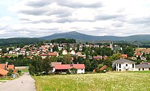
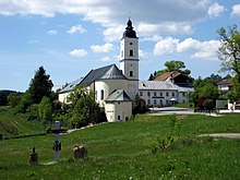
Sankt Oswald-Riedlhütte
| coat of arms | Germany map | |
|---|---|---|

|
Coordinates: 48 ° 54 ' N , 13 ° 23' E |
|
| Basic data | ||
| State : | Bavaria | |
| Administrative region : | Lower Bavaria | |
| County : | Freyung-Grafenau | |
| Height : | 741 m above sea level NHN | |
| Area : | 40.31 km 2 | |
| Residents: | 2899 (Dec. 31, 2019) | |
| Population density : | 72 inhabitants per km 2 | |
| Postcodes : | 94566, 94568 | |
| Area code : | 08553 | |
| License plate : | FRG, GRA, WOS | |
| Community key : | 09 2 72 143 | |
| Community structure: | 11 districts | |
| Address of the municipal administration: |
Lusenstrasse 2 94568 St. Oswald |
|
| Website : | ||
| Mayor : | Peter Schwankl ( CSU ) | |
| Location of the municipality of Sankt Oswald-Riedlhütte in the Freyung-Grafenau district | ||

Sankt Oswald-Riedlhütte is a municipality in the Lower Bavarian district of Freyung-Grafenau .
geography
Geographical location
Sankt Oswald-Riedlhütte is located in the Danube Forest region in the Inner Bavarian Forest about six kilometers north of Grafenau and borders directly on the Bavarian Forest National Park and the Czech Republic . The 1380 m high Plattenhausenriegel in the border ridge between Rachel and Lusen forms the highest point in the community.
Neighboring communities
Community structure
There are eleven districts:
history
Until the church is planted
Sankt Oswald-Riedlhütte in today's district Lower Bavaria belonged to the Electorate of Bavaria belonging Monastery Sankt Oswald . The monastery had a closed Hofmark here with lower court rights. Riedlhütte was part of the Straubing Rent Office and the Bärnstein Regional Court . In 1450, one of the oldest glassworks in the Bavarian Forest, the Riedlhütte , was built on site . It was in operation until December 22, 2009. Old maps of the region show a castle that was in Reichenberg. It was a hunting lodge and was used for bear hunting in the Bavarian Forest. It was burned down during the Thirty Years War . In the course of the administrative reforms in Bavaria , with the municipal edict of 1818, today's municipality with the name Oswald was created.
Name changes and exchange of territory
In 1875 the name was changed to Sankt Oswald . On May 1, 1978 there was an area swap with the neighboring community of Spiegelau , which gained around 200 inhabitants. On March 1, 1979, the name of the community was officially changed to "Sankt Oswald-Riedlhütte".
Population development
Between 1988 and 2018 the population decreased from 3,100 to 2,882 by 218 inhabitants or 7%.
- 1961: 3069 inhabitants
- 1970: 3239 inhabitants
- 1987: 3103 inhabitants
- 1991: 3189 inhabitants
- 1995: 3153 inhabitants
- 2000: 3234 inhabitants
- 2005: 3161 inhabitants
- 2010: 3043 inhabitants
- 2015: 2848 inhabitants
politics
mayor
The professional first mayor has been Peter Schwankl ( CSU ) since May 1, 2020 . In the runoff election on March 29, 2020, he prevailed against Klaus Pleintinger (Free Citizen List) with 52.5 percent. His predecessor in office was Helmut Vogl (Free Voting Association).
coat of arms
The coat of arms description reads: Divided by blue and gold; a silver glass beaker floating above between two obliquely crossed silver axes; a black raven with a silver ring in its beak, sitting on a green three-hill.
Economy and Infrastructure
Economy including agriculture and forestry
In 1998 there were none in the field of agriculture and forestry, 712 in the manufacturing sector and 27 in trade and transport at the place of work. In other economic sectors, 90 people were employed at the place of work subject to social security contributions. There were a total of 1,045 employees at the place of residence subject to social security contributions. There were three companies in the manufacturing sector and five in the construction sector. In addition, in 1999 there were 70 farms with an agriculturally used area of 563 ha. Of this, 31 ha were arable land and 531 ha were permanent green areas.
education
There are the following institutions (status: 2014):
- Kindergartens: 100 kindergarten places with 83 children
- Elementary schools: one with 22 teachers and 207 students
Due to the falling number of pupils, the elementary school was closed from the 2006/07 school year and converted into a secondary school. The primary school students are then distributed among the primary schools in Spiegelau and Neuschönau, who in return send their secondary school students to Riedlhütte.
traffic
The municipality is only connected to the regional traffic system by district roads.
Originally it was planned to lay the Zwiesel – Grafenau railway line through the municipality. Due to the resistance of the Grafenau city population, who wanted a train station close to the center, the railway line was rescheduled. This now runs past the community through the neighboring communities Spiegelau and Grafenau.
The community is connected to Grafenau by a bus line operated by the RBO bus company . In addition, two other bus routes, the so-called " Igelbusse " , operate between May and November. There is also a ski bus service during the Christmas and Carnival holidays.
The Bayerwald-Ticket is valid in the municipality of Sankt Oswald-Riedlhütte . Since May 1, 2010, the community has been involved in the GUTi - Guest Service Environment Ticket , along with other Bavarian Forest communities, which offers its guests free transport on all train and bus connections in the Bayerwald Ticket tariff area.
Architectural monuments
Soil monuments
Community personalities
- Ludwig Reiner (* 1937), agricultural scientist and university professor, born in Riedlhütte
- Alois Geiger (1890–1943), Nazi victim and head of the medical column in Spiegelau in the Bavarian Forest, street named after him
- Alfons Urban (* 1936), German CSU politician and councilor in Riedlhütte
Web links
- Entry on the coat of arms of Sankt Oswald-Riedlhütte in the database of the House of Bavarian History
Individual evidence
- ↑ "Data 2" sheet, Statistical Report A1200C 202041 Population of the municipalities, districts and administrative districts 1st quarter 2020 (population based on the 2011 census) ( help ).
- ↑ a b Mayor / Lord Mayor in municipalities belonging to the district (as of May 1st, 2020). (xlsx) Bavarian State Office for Statistics, accessed on June 12, 2020 .
- ↑ Glaswerk in Riedlhütte puts production on Bild-Online from December 21, 2009
- ^ Wilhelm Volkert (ed.): Handbook of Bavarian offices, communities and courts 1799–1980 . CH Beck, Munich 1983, ISBN 3-406-09669-7 , p. 473 .
- ^ Federal Statistical Office (ed.): Historical municipality directory for the Federal Republic of Germany. Name, border and key number changes in municipalities, counties and administrative districts from May 27, 1970 to December 31, 1982 . W. Kohlhammer GmbH, Stuttgart / Mainz 1983, ISBN 3-17-003263-1 , p. 628 .
- ↑ The run-off elections on Sunday, 29 March 2020. In: Wahl.info. March 30, 2020, accessed March 30, 2020 .


